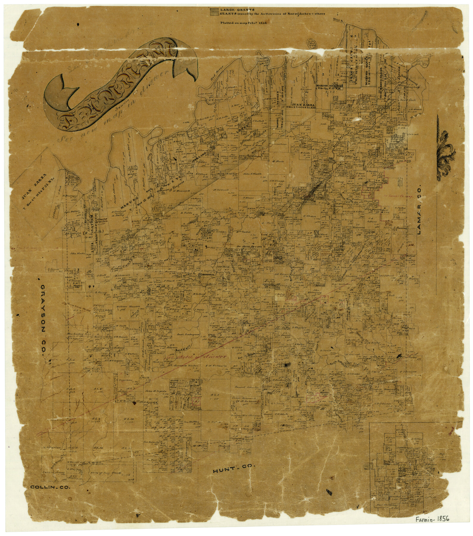
Fannin
-
Map/Doc
3535
-
Collection
General Map Collection
-
Object Dates
2/1856 (Creation Date)
-
People and Organizations
Texas General Land Office (Publisher)
-
Counties
Fannin
-
Subjects
County
-
Height x Width
21.9 x 19.2 inches
55.6 x 48.8 cm
-
Features
Peppercamp Creek
Chihuahua Road
Pilot Grove Creek
Middle Sulphur Creek
Long's Creek
Jonett's Creek
Mercer's Creek
Red River
Willow Oak Creek
Sandy Creek
Cliff's Crossing
Davis Creek
North Sulphur Creek
Bois D'Arc Creek
Honey Grove Creek
Blue River
Bullards Creek
Timber Creek
Sloans Creek
Bonham
Blanton's Creek
Powder Creek
Caney Creek
Brushey [sic] Creek
Coffeemill Creek
Part of: General Map Collection
Dimmit County Working Sketch 3

Print $20.00
- Digital $50.00
Dimmit County Working Sketch 3
1911
Size 16.5 x 22.5 inches
Map/Doc 68664
Hudspeth County Working Sketch 61

Print $20.00
- Digital $50.00
Hudspeth County Working Sketch 61
1992
Size 42.8 x 31.2 inches
Map/Doc 66346
Trinity County Rolled Sketch 7

Print $20.00
- Digital $50.00
Trinity County Rolled Sketch 7
1999
Size 24.8 x 36.3 inches
Map/Doc 8054
Dickens County Sketch File 16

Print $4.00
- Digital $50.00
Dickens County Sketch File 16
Size 7.4 x 11.1 inches
Map/Doc 20975

Texas Official Travel Map

Digital $50.00
Texas Official Travel Map
Size 33.4 x 36.1 inches
Map/Doc 94304
Cherokee County Sketch File 3

Print $4.00
- Digital $50.00
Cherokee County Sketch File 3
1849
Size 7.5 x 11.0 inches
Map/Doc 18115
Jasper County Working Sketch 12

Print $40.00
- Digital $50.00
Jasper County Working Sketch 12
1920
Size 50.6 x 38.3 inches
Map/Doc 66474
Hood County Rolled Sketch 7

Print $20.00
- Digital $50.00
Hood County Rolled Sketch 7
2009
Size 19.1 x 24.5 inches
Map/Doc 89062
Cameron County Sketch File 16

Print $18.00
- Digital $50.00
Cameron County Sketch File 16
1998
Size 11.2 x 8.6 inches
Map/Doc 76334
Amistad International Reservoir on Rio Grande 90

Print $20.00
- Digital $50.00
Amistad International Reservoir on Rio Grande 90
1950
Size 28.5 x 39.7 inches
Map/Doc 75520
Terrell County Working Sketch 6

Print $20.00
- Digital $50.00
Terrell County Working Sketch 6
1914
Size 15.7 x 21.9 inches
Map/Doc 62155
You may also like
Flight Mission No. CUG-1P, Frame 84, Kleberg County

Print $20.00
- Digital $50.00
Flight Mission No. CUG-1P, Frame 84, Kleberg County
1956
Size 18.4 x 22.3 inches
Map/Doc 86149
Comal County Working Sketch 1

Print $20.00
- Digital $50.00
Comal County Working Sketch 1
1919
Size 22.1 x 18.2 inches
Map/Doc 68167
Jefferson County NRC Article 33.136 Sketch 6

Print $4.00
- Digital $50.00
Jefferson County NRC Article 33.136 Sketch 6
2005
Size 14.1 x 8.6 inches
Map/Doc 83171
Somervell County

Print $20.00
- Digital $50.00
Somervell County
1941
Size 29.2 x 27.1 inches
Map/Doc 95642
El Paso County Rolled Sketch 49

Print $40.00
- Digital $50.00
El Paso County Rolled Sketch 49
Size 10.5 x 99.9 inches
Map/Doc 8875
Webb County Rolled Sketch EF2

Print $20.00
- Digital $50.00
Webb County Rolled Sketch EF2
1932
Size 40.4 x 29.9 inches
Map/Doc 8224
Aransas County Rolled Sketch 17

Aransas County Rolled Sketch 17
1953
Size 10.5 x 15.2 inches
Map/Doc 42219
Edwards County Working Sketch 108

Print $40.00
- Digital $50.00
Edwards County Working Sketch 108
1972
Size 61.2 x 37.1 inches
Map/Doc 68984
Flight Mission No. BRA-3M, Frame 122, Jefferson County

Print $20.00
- Digital $50.00
Flight Mission No. BRA-3M, Frame 122, Jefferson County
1953
Size 18.7 x 22.3 inches
Map/Doc 85396
[Blocks T2, T3, and K13]
![90997, [Blocks T2, T3, and K13], Twichell Survey Records](https://historictexasmaps.com/wmedia_w700/maps/90997-1.tif.jpg)
Print $20.00
- Digital $50.00
[Blocks T2, T3, and K13]
Size 20.7 x 19.9 inches
Map/Doc 90997
Sketch of a portion of the Texas Coast showing the relative positions of different harbours with the interior Military Posts, and the roads communicating with them, also two new routes from Black Point and Lamar to San Antonio

Print $20.00
- Digital $50.00
Sketch of a portion of the Texas Coast showing the relative positions of different harbours with the interior Military Posts, and the roads communicating with them, also two new routes from Black Point and Lamar to San Antonio
1855
Size 27.3 x 18.3 inches
Map/Doc 72710
Jeff Davis County Rolled Sketch 31

Print $20.00
- Digital $50.00
Jeff Davis County Rolled Sketch 31
1983
Size 40.6 x 44.1 inches
Map/Doc 9268