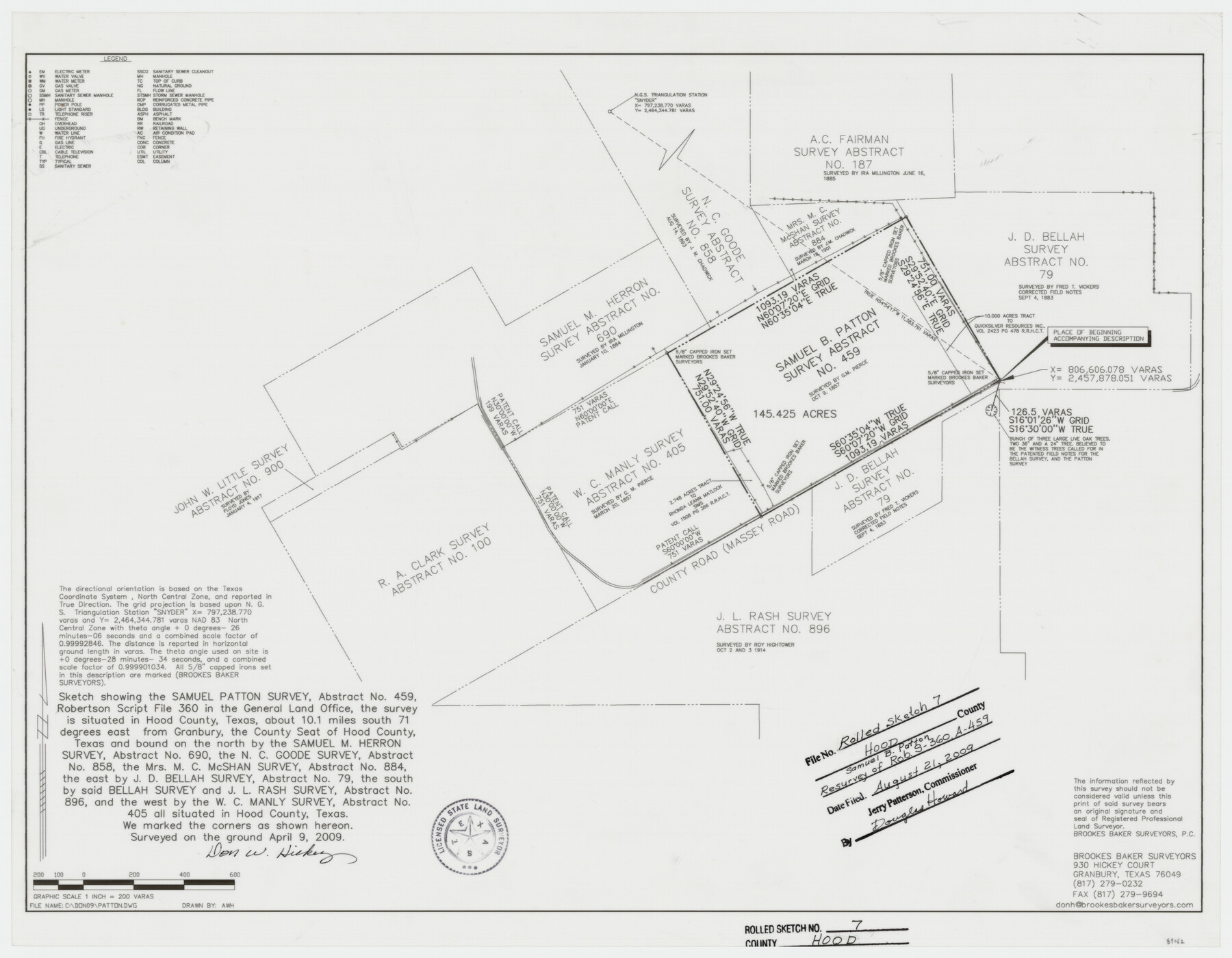
Hood County Rolled Sketch 7
Sketch showing the Samuel Patton survey, abstract no. 459
-
Map/Doc
89062
-
Collection
General Map Collection
-
Object Dates
2009/4/9 (Creation Date)
2009/8/21 (File Date)
-
People and Organizations
Don W. Hickey (Surveyor/Engineer)
-
Counties
Hood
-
Subjects
Surveying Rolled Sketch
-
Height x Width
19.1 x 24.5 inches
48.5 x 62.2 cm
-
Medium
mylar, print
-
Scale
1" = 200 varas
Part of: General Map Collection

Map of Eastland Co.

Print $20.00
- Digital $50.00
Map of Eastland Co.
1889
Size 41.6 x 42.7 inches
Map/Doc 4710
Atkinson's Casket Gems of Literature, Wit and Sentiment

Atkinson's Casket Gems of Literature, Wit and Sentiment
Size 9.2 x 6.1 inches
Map/Doc 95957
Map of La Salle County

Print $20.00
- Digital $50.00
Map of La Salle County
1877
Size 29.8 x 21.1 inches
Map/Doc 3797
[Right of Way and Track Map, the Missouri, Kansas and Texas Ry. of Texas - Henrietta Division]
![64757, [Right of Way and Track Map, the Missouri, Kansas and Texas Ry. of Texas - Henrietta Division], General Map Collection](https://historictexasmaps.com/wmedia_w700/maps/64757.tif.jpg)
Print $20.00
- Digital $50.00
[Right of Way and Track Map, the Missouri, Kansas and Texas Ry. of Texas - Henrietta Division]
1918
Size 11.8 x 26.9 inches
Map/Doc 64757
Menard County Sketch File 21

Print $40.00
- Digital $50.00
Menard County Sketch File 21
1913
Size 14.1 x 14.8 inches
Map/Doc 31551
Harris County Sketch File 23a

Print $13.00
- Digital $50.00
Harris County Sketch File 23a
1839
Size 9.7 x 6.0 inches
Map/Doc 25379

Denton County Sketch File 1

Print $2.00
- Digital $50.00
Denton County Sketch File 1
Size 8.4 x 10.6 inches
Map/Doc 20681
Flight Mission No. BRA-7M, Frame 193, Jefferson County

Print $20.00
- Digital $50.00
Flight Mission No. BRA-7M, Frame 193, Jefferson County
1953
Size 18.7 x 22.4 inches
Map/Doc 85561
Childress County Working Sketch Graphic Index

Print $20.00
- Digital $50.00
Childress County Working Sketch Graphic Index
1978
Size 45.5 x 34.3 inches
Map/Doc 76493
Ward County Working Sketch 50

Print $20.00
- Digital $50.00
Ward County Working Sketch 50
1976
Size 31.1 x 29.1 inches
Map/Doc 72356
You may also like
Anderson County Rolled Sketch 7

Print $20.00
- Digital $50.00
Anderson County Rolled Sketch 7
1941
Size 42.2 x 44.9 inches
Map/Doc 8364
Hardin County Sketch File 55

Print $40.00
- Digital $50.00
Hardin County Sketch File 55
1924
Size 14.2 x 13.3 inches
Map/Doc 25220
[Surveys along the San Gabriel River]
![78375, [Surveys along the San Gabriel River], General Map Collection](https://historictexasmaps.com/wmedia_w700/maps/78375.tif.jpg)
Print $2.00
- Digital $50.00
[Surveys along the San Gabriel River]
Size 9.0 x 6.3 inches
Map/Doc 78375
Hutchinson County Sketch File 26

Print $20.00
- Digital $50.00
Hutchinson County Sketch File 26
1920
Size 18.6 x 17.4 inches
Map/Doc 11816
Liberty County Working Sketch 49a

Print $20.00
- Digital $50.00
Liberty County Working Sketch 49a
1955
Size 32.7 x 39.9 inches
Map/Doc 70508
Chambers County Boundary File 3

Print $112.00
- Digital $50.00
Chambers County Boundary File 3
Size 52.5 x 3.9 inches
Map/Doc 51249
Uvalde County Sketch File 19

Print $4.00
- Digital $50.00
Uvalde County Sketch File 19
1882
Size 10.6 x 8.6 inches
Map/Doc 39000
Mason County Rolled Sketch 2

Print $20.00
- Digital $50.00
Mason County Rolled Sketch 2
1952
Size 32.9 x 26.7 inches
Map/Doc 6675
Flight Mission No. CUG-1P, Frame 45, Kleberg County

Print $20.00
- Digital $50.00
Flight Mission No. CUG-1P, Frame 45, Kleberg County
1956
Size 18.5 x 22.2 inches
Map/Doc 86123
Comanche County Sketch File 19

Print $12.00
- Digital $50.00
Comanche County Sketch File 19
Size 13.0 x 8.0 inches
Map/Doc 19093
Flight Mission No. CRC-3R, Frame 50, Chambers County

Print $20.00
- Digital $50.00
Flight Mission No. CRC-3R, Frame 50, Chambers County
1956
Size 18.7 x 22.3 inches
Map/Doc 84823
Map No. 1. Eastern States designed to accompany Smith's Geography for School

Print $20.00
- Digital $50.00
Map No. 1. Eastern States designed to accompany Smith's Geography for School
1850
Size 9.8 x 12.1 inches
Map/Doc 93885