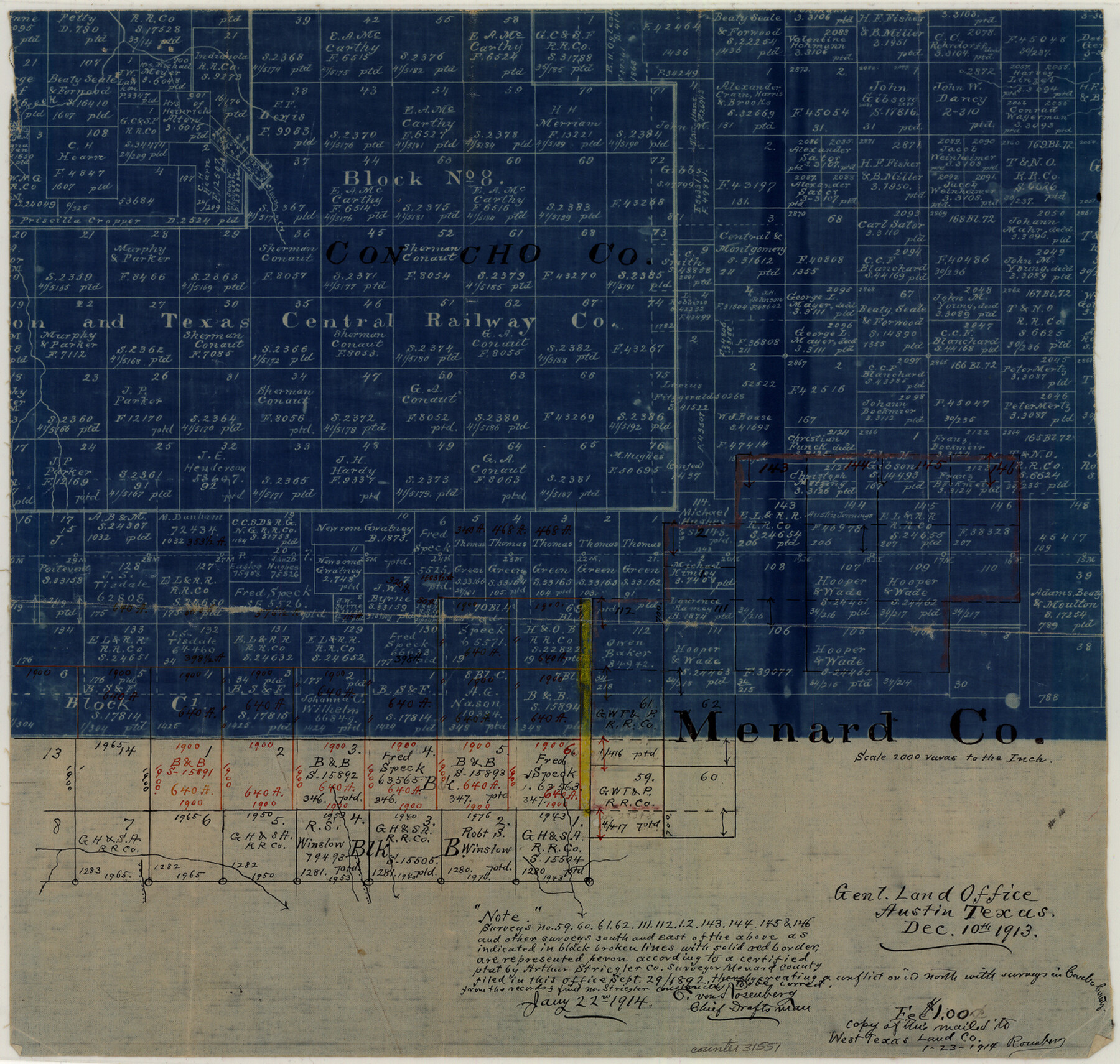
Menard County Sketch File 21
[Office sketch on line of Menard and Concho Counties]
-
Map/Doc
31551
-
Collection
General Map Collection
-
Object Dates
12/10/1913 (Creation Date)
-
People and Organizations
E. von Rosenberg (Draftsman)
-
Counties
Menard Concho
-
Subjects
Surveying Sketch File
-
Height x Width
14.1 x 14.8 inches
35.8 x 37.6 cm
-
Medium
blueprint/diazo
-
Scale
1:2000
-
Features
Clauss Creek
Part of: General Map Collection
Nueces County Rolled Sketch 97

Print $68.00
- Digital $50.00
Nueces County Rolled Sketch 97
1983
Size 24.2 x 36.9 inches
Map/Doc 7057
Brewster County Rolled Sketch 97

Print $20.00
- Digital $50.00
Brewster County Rolled Sketch 97
1952
Size 31.6 x 30.7 inches
Map/Doc 5254
Revised Map of Matagorda Bay and Vicinity in Matagorda and Calhoun Counties, showing Subdivision for Mineral Development

Print $40.00
- Digital $50.00
Revised Map of Matagorda Bay and Vicinity in Matagorda and Calhoun Counties, showing Subdivision for Mineral Development
1959
Size 43.8 x 57.0 inches
Map/Doc 1910
Zapata County Rolled Sketch 25

Print $20.00
- Digital $50.00
Zapata County Rolled Sketch 25
Size 45.7 x 37.9 inches
Map/Doc 10172
Val Verde County Sketch File 44

Print $22.00
- Digital $50.00
Val Verde County Sketch File 44
1940
Size 9.0 x 14.2 inches
Map/Doc 39309

Flight Mission No. CGI-1N, Frame 141, Cameron County

Print $20.00
- Digital $50.00
Flight Mission No. CGI-1N, Frame 141, Cameron County
1955
Size 18.5 x 22.2 inches
Map/Doc 84497

St. Louis, Brownsville & Mexico Railway Location Map from Mile 0 to Mile 20

Print $40.00
- Digital $50.00
St. Louis, Brownsville & Mexico Railway Location Map from Mile 0 to Mile 20
1906
Size 19.5 x 74.5 inches
Map/Doc 64075
Outer Continental Shelf Leasing Maps (Texas Offshore Operations)

Print $20.00
- Digital $50.00
Outer Continental Shelf Leasing Maps (Texas Offshore Operations)
1954
Size 16.2 x 15.7 inches
Map/Doc 75837
Flight Mission No. CRC-1R, Frame 154, Chambers County

Print $20.00
- Digital $50.00
Flight Mission No. CRC-1R, Frame 154, Chambers County
1956
Size 18.9 x 22.5 inches
Map/Doc 84716
Terrell County Rolled Sketch 37

Print $20.00
- Digital $50.00
Terrell County Rolled Sketch 37
1940
Size 23.8 x 33.3 inches
Map/Doc 7941
You may also like
Comanche County

Print $20.00
- Digital $50.00
Comanche County
1896
Size 41.7 x 44.8 inches
Map/Doc 4736
Aransas County Rolled Sketch 27C

Print $20.00
- Digital $50.00
Aransas County Rolled Sketch 27C
1979
Size 17.3 x 19.3 inches
Map/Doc 5056
Knox County Working Sketch 2

Print $20.00
- Digital $50.00
Knox County Working Sketch 2
1913
Size 22.7 x 14.2 inches
Map/Doc 70244
Lee County Working Sketch 13

Print $20.00
- Digital $50.00
Lee County Working Sketch 13
1981
Size 33.4 x 35.7 inches
Map/Doc 70392
Milam County Boundary File 1

Print $8.00
- Digital $50.00
Milam County Boundary File 1
Size 12.7 x 8.2 inches
Map/Doc 57198
Duval County Boundary File 2

Print $32.00
- Digital $50.00
Duval County Boundary File 2
Size 12.4 x 8.1 inches
Map/Doc 52703
Erath County Working Sketch 1

Print $20.00
- Digital $50.00
Erath County Working Sketch 1
Size 16.7 x 20.7 inches
Map/Doc 69082
[Vague Sketches in Brooks County, Texas]
![83352, [Vague Sketches in Brooks County, Texas], Maddox Collection](https://historictexasmaps.com/wmedia_w700/maps/83352.tif.jpg)
Print $20.00
- Digital $50.00
[Vague Sketches in Brooks County, Texas]
1906
Size 17.8 x 19.9 inches
Map/Doc 83352
[Sketch of surveys north of Canadian River, Hemphill County, Texas]
![484, [Sketch of surveys north of Canadian River, Hemphill County, Texas], Maddox Collection](https://historictexasmaps.com/wmedia_w700/maps/00484-1.tif.jpg)
Print $3.00
- Digital $50.00
[Sketch of surveys north of Canadian River, Hemphill County, Texas]
1882
Size 10.5 x 13.5 inches
Map/Doc 484
Flight Mission No. BRA-9M, Frame 62, Jefferson County

Print $20.00
- Digital $50.00
Flight Mission No. BRA-9M, Frame 62, Jefferson County
1953
Size 18.7 x 22.3 inches
Map/Doc 85645
The Republic County of Milam. January 29, 1842

Print $20.00
The Republic County of Milam. January 29, 1842
2020
Size 17.4 x 21.6 inches
Map/Doc 96231
Angelina County Working Sketch 20

Print $20.00
- Digital $50.00
Angelina County Working Sketch 20
1955
Size 18.8 x 15.0 inches
Map/Doc 67101