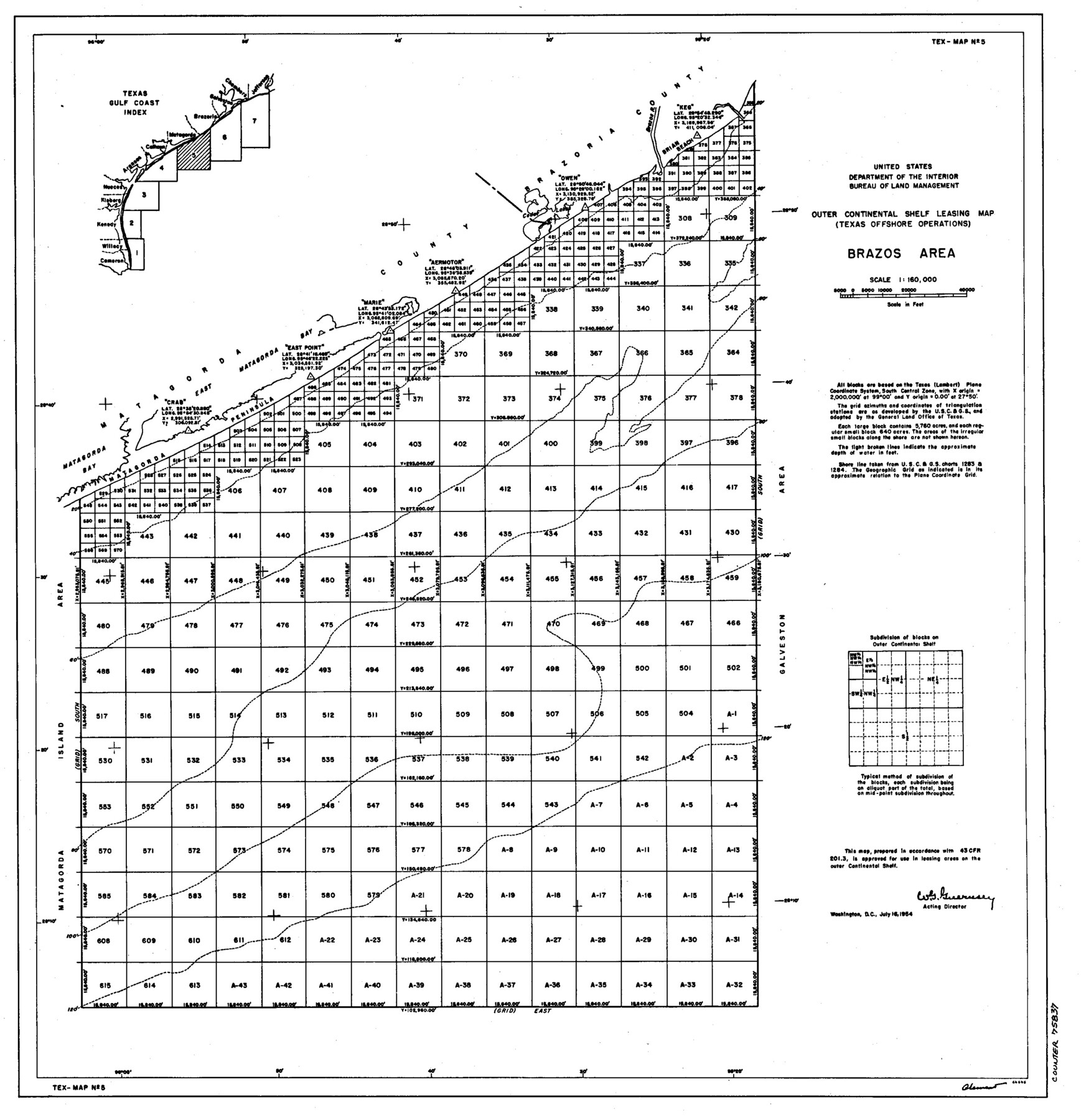
Outer Continental Shelf Leasing Maps (Texas Offshore Operations)
D-7-1; D-7-2
-
Map/Doc
75837
-
Collection
General Map Collection
-
Object Dates
1954 (Creation Date)
-
Subjects
Energy Offshore Submerged Area
-
Height x Width
16.2 x 15.7 inches
41.1 x 39.9 cm
Part of: General Map Collection
Medina County Rolled Sketch 15

Print $20.00
- Digital $50.00
Medina County Rolled Sketch 15
1980
Size 25.2 x 20.3 inches
Map/Doc 6749
Flight Mission No. DQN-1K, Frame 116, Calhoun County

Print $20.00
- Digital $50.00
Flight Mission No. DQN-1K, Frame 116, Calhoun County
1953
Size 18.7 x 22.4 inches
Map/Doc 84182
Maverick County Sketch File 10a

Print $19.00
- Digital $50.00
Maverick County Sketch File 10a
1878
Size 15.4 x 10.0 inches
Map/Doc 31083
Wharton County Working Sketch 16

Print $20.00
- Digital $50.00
Wharton County Working Sketch 16
1952
Size 23.8 x 26.8 inches
Map/Doc 72480
Kinney County Sketch File 24

Print $6.00
- Digital $50.00
Kinney County Sketch File 24
1928
Size 14.2 x 8.8 inches
Map/Doc 29164
Travis County Rolled Sketch 29

Print $20.00
- Digital $50.00
Travis County Rolled Sketch 29
1946
Size 25.1 x 37.8 inches
Map/Doc 8031
Flight Mission No. DAG-23K, Frame 146, Matagorda County

Print $20.00
- Digital $50.00
Flight Mission No. DAG-23K, Frame 146, Matagorda County
1953
Size 17.0 x 22.4 inches
Map/Doc 86494
Brooks County Working Sketch 10

Print $20.00
- Digital $50.00
Brooks County Working Sketch 10
1939
Size 32.1 x 32.8 inches
Map/Doc 67794
Brewster County Sketch File NS-6

Print $40.00
- Digital $50.00
Brewster County Sketch File NS-6
1944
Size 31.8 x 18.6 inches
Map/Doc 10989
Flight Mission No. CUG-3P, Frame 139, Kleberg County

Print $20.00
- Digital $50.00
Flight Mission No. CUG-3P, Frame 139, Kleberg County
1956
Size 18.6 x 22.4 inches
Map/Doc 86274
Hudspeth County Sketch File 11

Print $14.00
- Digital $50.00
Hudspeth County Sketch File 11
Size 14.5 x 8.9 inches
Map/Doc 26903

You may also like
St. Louis Southwestern Railway of Texas

Print $40.00
- Digital $50.00
St. Louis Southwestern Railway of Texas
1905
Size 15.3 x 87.2 inches
Map/Doc 64445
Flight Mission No. BRA-16M, Frame 146, Jefferson County

Print $20.00
- Digital $50.00
Flight Mission No. BRA-16M, Frame 146, Jefferson County
1953
Size 18.4 x 22.3 inches
Map/Doc 85752
Fort Bend County Working Sketch Graphic Index

Print $20.00
- Digital $50.00
Fort Bend County Working Sketch Graphic Index
1931
Size 40.7 x 41.9 inches
Map/Doc 76545
Marion County Sketch File 17

Print $20.00
- Digital $50.00
Marion County Sketch File 17
Size 32.7 x 19.0 inches
Map/Doc 12026
[Surveys in the Bexar District along the Cibolo Creek]
![86, [Surveys in the Bexar District along the Cibolo Creek], General Map Collection](https://historictexasmaps.com/wmedia_w700/maps/86.tif.jpg)
Print $20.00
- Digital $50.00
[Surveys in the Bexar District along the Cibolo Creek]
1846
Size 17.0 x 17.8 inches
Map/Doc 86
Map of University Land being a part of Block L, El Paso County, Texas

Print $20.00
- Digital $50.00
Map of University Land being a part of Block L, El Paso County, Texas
1945
Size 26.1 x 25.8 inches
Map/Doc 2423
Lampasas County Boundary File 10

Print $11.00
- Digital $50.00
Lampasas County Boundary File 10
Size 12.8 x 7.9 inches
Map/Doc 56184
Terrell County Rolled Sketch 38

Print $20.00
- Digital $50.00
Terrell County Rolled Sketch 38
Size 22.7 x 18.0 inches
Map/Doc 7942
La Salle County Rolled Sketch 24

Print $20.00
- Digital $50.00
La Salle County Rolled Sketch 24
1955
Size 36.7 x 39.4 inches
Map/Doc 10655
Galveston County Sketch File 43

Print $40.00
- Digital $50.00
Galveston County Sketch File 43
1915
Size 19.4 x 15.1 inches
Map/Doc 11539
San Patricio County Rolled Sketch 20A

Print $20.00
- Digital $50.00
San Patricio County Rolled Sketch 20A
Size 25.9 x 30.3 inches
Map/Doc 7579
Railroad Track Map, H&TCRRCo., Falls County, Texas

Print $4.00
- Digital $50.00
Railroad Track Map, H&TCRRCo., Falls County, Texas
1918
Size 11.7 x 18.7 inches
Map/Doc 62841