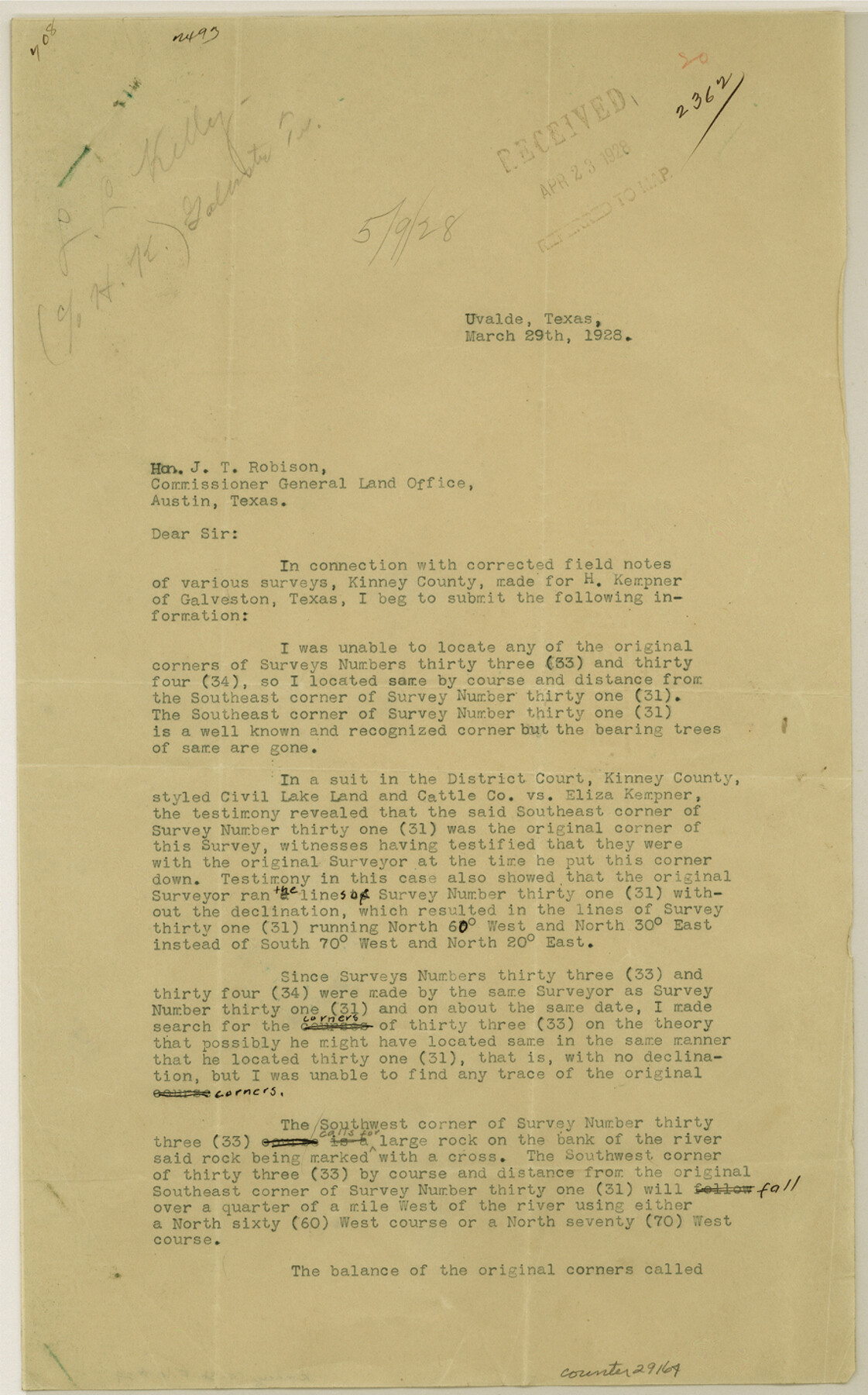
Kinney County Sketch File 24
[Letter in regard to location of the Kempner Lands]
-
Map/Doc
29164
-
Collection
General Map Collection
-
Object Dates
3/29/1928 (Creation Date)
4/23/1928 (File Date)
-
People and Organizations
E.R. Benson (Surveyor/Engineer)
-
Counties
Kinney
-
Subjects
Surveying Sketch File
-
Height x Width
14.2 x 8.8 inches
36.1 x 22.4 cm
-
Medium
paper, print
Part of: General Map Collection
Galveston County NRC Article 33.136 Sketch 55A

Print $28.00
- Digital $50.00
Galveston County NRC Article 33.136 Sketch 55A
2009
Size 24.0 x 36.0 inches
Map/Doc 94616

Concho County Working Sketch 7

Print $20.00
- Digital $50.00
Concho County Working Sketch 7
1948
Size 44.3 x 46.0 inches
Map/Doc 68189
Lynn County Rolled Sketch 15

Print $20.00
- Digital $50.00
Lynn County Rolled Sketch 15
1986
Size 36.4 x 24.5 inches
Map/Doc 6651
La Salle County Sketch File A

Print $30.00
- Digital $50.00
La Salle County Sketch File A
1880
Size 8.1 x 12.5 inches
Map/Doc 29532
Travis County Sketch File 61

Print $8.00
- Digital $50.00
Travis County Sketch File 61
1948
Size 14.4 x 8.8 inches
Map/Doc 38427
Newton County Working Sketch 6

Print $20.00
- Digital $50.00
Newton County Working Sketch 6
1930
Size 35.5 x 25.9 inches
Map/Doc 71252
McMullen County Rolled Sketch 21

Print $40.00
- Digital $50.00
McMullen County Rolled Sketch 21
Size 68.9 x 40.0 inches
Map/Doc 9502
[Gulf Coast of Texas]
![72705, [Gulf Coast of Texas], General Map Collection](https://historictexasmaps.com/wmedia_w700/maps/72705.tif.jpg)
Print $20.00
- Digital $50.00
[Gulf Coast of Texas]
1881
Size 28.7 x 18.2 inches
Map/Doc 72705
Hemphill County Rolled Sketch 18

Print $20.00
- Digital $50.00
Hemphill County Rolled Sketch 18
Size 23.6 x 35.0 inches
Map/Doc 6200
Railroad Track Map, T&PRRCo., Culberson County, Texas

Print $4.00
- Digital $50.00
Railroad Track Map, T&PRRCo., Culberson County, Texas
1910
Size 11.8 x 18.7 inches
Map/Doc 62826
Sterling County Working Sketch 2

Print $20.00
- Digital $50.00
Sterling County Working Sketch 2
1941
Size 19.9 x 26.2 inches
Map/Doc 63984
You may also like
San Jacinto County Working Sketch 23

Print $40.00
- Digital $50.00
San Jacinto County Working Sketch 23
1940
Size 31.5 x 53.8 inches
Map/Doc 63736
[Blocks K3-K8 in East half of County]
![90506, [Blocks K3-K8 in East half of County], Twichell Survey Records](https://historictexasmaps.com/wmedia_w700/maps/90506-1.tif.jpg)
Print $2.00
- Digital $50.00
[Blocks K3-K8 in East half of County]
Size 8.8 x 10.5 inches
Map/Doc 90506
General Highway Map, Upton County, Texas

Print $20.00
General Highway Map, Upton County, Texas
1961
Size 24.7 x 18.1 inches
Map/Doc 79693
Proceedings of the National Railroad Convention at St. Louis, Mo., Nov. 23 and 24, 1875, in regard to the construction of a Southern Trans-Continental Railway Line from the Mississippi Valley to the Pacific Ocean

Proceedings of the National Railroad Convention at St. Louis, Mo., Nov. 23 and 24, 1875, in regard to the construction of a Southern Trans-Continental Railway Line from the Mississippi Valley to the Pacific Ocean
Size 9.3 x 6.1 inches
Map/Doc 93961
Harris County Sketch File 8

Print $23.00
- Digital $50.00
Harris County Sketch File 8
Size 15.3 x 11.9 inches
Map/Doc 25338
Hansford County Sketch File 1

Print $7.00
- Digital $50.00
Hansford County Sketch File 1
1888
Size 39.0 x 31.3 inches
Map/Doc 10475
King County Sketch File 9

Print $20.00
- Digital $50.00
King County Sketch File 9
Size 23.5 x 33.0 inches
Map/Doc 11937
Webb County Working Sketch 18

Print $20.00
- Digital $50.00
Webb County Working Sketch 18
1923
Size 18.6 x 12.8 inches
Map/Doc 72383
Smith County Rolled Sketch 8

Print $20.00
- Digital $50.00
Smith County Rolled Sketch 8
2006
Size 24.7 x 37.0 inches
Map/Doc 95411
Navigation Maps of Gulf Intracoastal Waterway, Port Arthur to Brownsville, Texas

Print $4.00
- Digital $50.00
Navigation Maps of Gulf Intracoastal Waterway, Port Arthur to Brownsville, Texas
1951
Size 16.7 x 21.4 inches
Map/Doc 65423
El Paso County Sketch File 35

Print $10.00
- Digital $50.00
El Paso County Sketch File 35
1886
Size 11.3 x 8.9 inches
Map/Doc 22161
Loving County Working Sketch 23

Print $20.00
- Digital $50.00
Loving County Working Sketch 23
1952
Size 15.1 x 31.5 inches
Map/Doc 70657