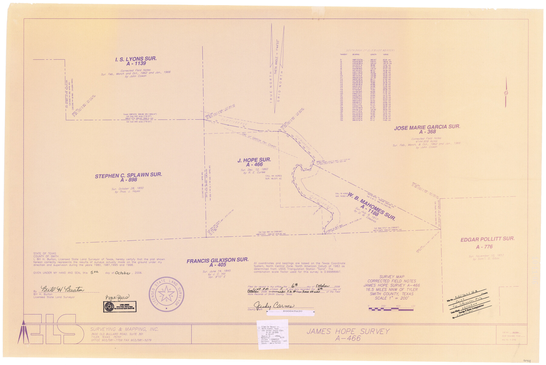
Smith County Rolled Sketch 8
Survey map, corrected field notes James Hope survey A-466
-
Map/Doc
95411
-
Collection
General Map Collection
-
Object Dates
2006/10/5 (Creation Date)
2019/5/16 (File Date)
-
People and Organizations
Bill H. Burton (Surveyor/Engineer)
-
Counties
Smith
-
Subjects
Surveying Rolled Sketch
-
Height x Width
24.7 x 37.0 inches
62.7 x 94.0 cm
-
Medium
blueprint/diazo
-
Scale
1" = 200'
-
Comments
Filed for information only
Part of: General Map Collection
Galveston to Rio Grande

Print $20.00
- Digital $50.00
Galveston to Rio Grande
1946
Size 44.8 x 36.9 inches
Map/Doc 69953
Frio County Rolled Sketch 5

Print $20.00
- Digital $50.00
Frio County Rolled Sketch 5
Size 25.7 x 23.0 inches
Map/Doc 5917
Flight Mission No. CRC-3R, Frame 10, Chambers County

Print $20.00
- Digital $50.00
Flight Mission No. CRC-3R, Frame 10, Chambers County
1956
Size 18.5 x 22.2 inches
Map/Doc 84784
Hardin County Working Sketch 32

Print $20.00
- Digital $50.00
Hardin County Working Sketch 32
1978
Size 41.7 x 38.0 inches
Map/Doc 63430
Reagan County Sketch File 14

Print $6.00
- Digital $50.00
Reagan County Sketch File 14
Size 11.3 x 8.8 inches
Map/Doc 34993

[Aerial Photograph of Galveston Island and the Gulf of Mexico]
![83434, [Aerial Photograph of Galveston Island and the Gulf of Mexico], General Map Collection](https://historictexasmaps.com/wmedia_w700/maps/83434.tif.jpg)
Print $20.00
- Digital $50.00
[Aerial Photograph of Galveston Island and the Gulf of Mexico]
1956
Size 15.5 x 12.7 inches
Map/Doc 83434
Guadalupe County

Print $20.00
- Digital $50.00
Guadalupe County
1880
Size 24.9 x 22.6 inches
Map/Doc 4553
[Surveys along the San Jacinto River]
![62, [Surveys along the San Jacinto River], General Map Collection](https://historictexasmaps.com/wmedia_w700/maps/62.tif.jpg)
Print $3.00
- Digital $50.00
[Surveys along the San Jacinto River]
1841
Size 10.7 x 14.5 inches
Map/Doc 62
Brazoria County State Real Property Sketch 1

Print $20.00
- Digital $50.00
Brazoria County State Real Property Sketch 1
1997
Size 24.4 x 34.8 inches
Map/Doc 80127
Williamson County Sketch File 29

Print $18.00
- Digital $50.00
Williamson County Sketch File 29
Size 10.2 x 8.2 inches
Map/Doc 40377
Edwards County Sketch File 49

Print $20.00
- Digital $50.00
Edwards County Sketch File 49
1958
Size 25.6 x 27.9 inches
Map/Doc 11444
You may also like
[Blocks 3T, 1, and 6T]
![91421, [Blocks 3T, 1, and 6T], Twichell Survey Records](https://historictexasmaps.com/wmedia_w700/maps/91421-1.tif.jpg)
Print $20.00
- Digital $50.00
[Blocks 3T, 1, and 6T]
Size 26.2 x 25.7 inches
Map/Doc 91421
Map of San Saba County

Print $20.00
- Digital $50.00
Map of San Saba County
1858
Size 21.6 x 23.5 inches
Map/Doc 4019
[Sketch for Mineral Application 27669 - Trinity River, Frank R. Graves]
![2858, [Sketch for Mineral Application 27669 - Trinity River, Frank R. Graves], General Map Collection](https://historictexasmaps.com/wmedia_w700/maps/2858-1.tif.jpg)
Print $40.00
- Digital $50.00
[Sketch for Mineral Application 27669 - Trinity River, Frank R. Graves]
1934
Size 28.3 x 83.2 inches
Map/Doc 2858
Flight Mission No. BQR-22K, Frame 47, Brazoria County

Print $20.00
- Digital $50.00
Flight Mission No. BQR-22K, Frame 47, Brazoria County
1953
Size 18.8 x 22.4 inches
Map/Doc 84131
Montgomery County Sketch File 6

Print $4.00
- Digital $50.00
Montgomery County Sketch File 6
Size 4.6 x 5.7 inches
Map/Doc 31781
[Mary Fury and B. H. Epperson surveys]
![93068, [Mary Fury and B. H. Epperson surveys], Twichell Survey Records](https://historictexasmaps.com/wmedia_w700/maps/93068-1.tif.jpg)
Print $3.00
- Digital $50.00
[Mary Fury and B. H. Epperson surveys]
Size 10.8 x 15.7 inches
Map/Doc 93068
Val Verde County Sketch File Z15

Print $22.00
- Digital $50.00
Val Verde County Sketch File Z15
1902
Size 15.2 x 17.2 inches
Map/Doc 39144
Texas State Capitol Land

Print $40.00
- Digital $50.00
Texas State Capitol Land
1915
Size 76.6 x 55.6 inches
Map/Doc 93156
[G.C. and S. F. R.R. Co. Through Bosque County from McLennan Co. and E. to Hill Co. Station M. P. 259 to M. P. 297]
![64563, [G.C. and S. F. R.R. Co. Through Bosque County from McLennan Co. and E. to Hill Co. Station M. P. 259 to M. P. 297], General Map Collection](https://historictexasmaps.com/wmedia_w700/maps/64563-1.tif.jpg)
Print $40.00
- Digital $50.00
[G.C. and S. F. R.R. Co. Through Bosque County from McLennan Co. and E. to Hill Co. Station M. P. 259 to M. P. 297]
Size 21.7 x 120.5 inches
Map/Doc 64563
Brooks County Rolled Sketch 21

Print $40.00
- Digital $50.00
Brooks County Rolled Sketch 21
1943
Size 51.5 x 41.3 inches
Map/Doc 8537
Right of Way and Track Map, The Missouri, Kansas and Texas Ry. of Texas operated by the Missouri, Kansas and Texas Ry. of Texas, Henrietta Division

Print $40.00
- Digital $50.00
Right of Way and Track Map, The Missouri, Kansas and Texas Ry. of Texas operated by the Missouri, Kansas and Texas Ry. of Texas, Henrietta Division
1918
Size 25.5 x 57.0 inches
Map/Doc 64071
Liberty County Rolled Sketch F

Print $20.00
- Digital $50.00
Liberty County Rolled Sketch F
Size 24.9 x 25.5 inches
Map/Doc 6621