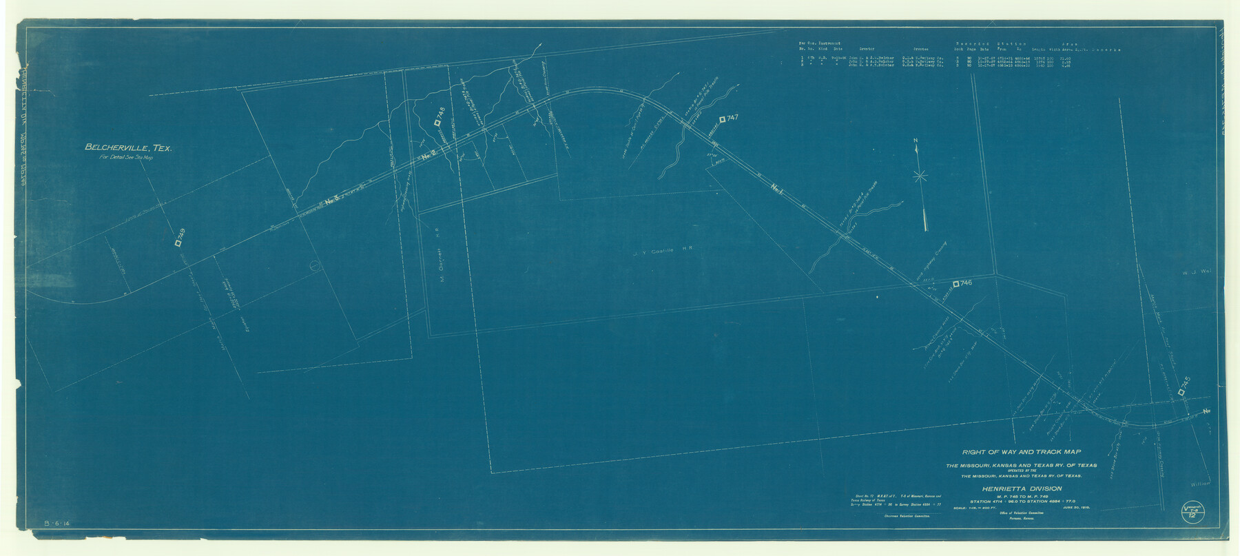
Right of Way and Track Map, The Missouri, Kansas and Texas Ry. of Texas operated by the Missouri, Kansas and Texas Ry. of Texas, Henrietta Division
M.P. 745 to M.P. 749, Station 4714+96.0 to Station 4884+77.0
Z-2-20
-
Map/Doc
64071
-
Collection
General Map Collection
-
Object Dates
1918/6/30 (Creation Date)
-
People and Organizations
Office of Valuation Committee (Publisher)
-
Counties
Montague
-
Subjects
Railroads
-
Height x Width
25.5 x 57.0 inches
64.8 x 144.8 cm
-
Medium
blueprint/diazo
-
Scale
1" = 400 feet
-
Comments
See 64065-64070 and 64072-64074 for other segments of the map. See 64064 (PDF) for the documents/letter that accompanied the map.
-
Features
MK&T
Belcherville
[Route] to Denison
[Route] to Wichita Falls
Part of: General Map Collection
Polk County Sketch File 17

Print $4.00
- Digital $50.00
Polk County Sketch File 17
1861
Size 8.1 x 9.5 inches
Map/Doc 34163
Amistad International Reservoir on Rio Grande 101

Print $20.00
- Digital $50.00
Amistad International Reservoir on Rio Grande 101
1950
Size 28.5 x 40.9 inches
Map/Doc 75532
Brazoria County Sketch File 15a

Print $4.00
- Digital $50.00
Brazoria County Sketch File 15a
1892
Size 14.2 x 8.7 inches
Map/Doc 14979
Jasper County Sketch File 30

Print $20.00
- Digital $50.00
Jasper County Sketch File 30
1948
Size 11.3 x 8.8 inches
Map/Doc 27858
Hays County Sketch File A

Print $6.00
- Digital $50.00
Hays County Sketch File A
1881
Size 10.8 x 8.4 inches
Map/Doc 26186
Map of Refugio County

Print $20.00
- Digital $50.00
Map of Refugio County
1875
Size 20.9 x 28.2 inches
Map/Doc 3988
Gillespie County Sketch File 16

Print $20.00
- Digital $50.00
Gillespie County Sketch File 16
1951
Size 18.2 x 17.9 inches
Map/Doc 11557
Map of Reeves County

Print $20.00
- Digital $50.00
Map of Reeves County
1892
Size 47.2 x 35.4 inches
Map/Doc 78401
Intracoastal Waterway in Texas - Corpus Christi to Point Isabel including Arroyo Colorado to Mo. Pac. R.R. Bridge Near Harlingen

Print $20.00
- Digital $50.00
Intracoastal Waterway in Texas - Corpus Christi to Point Isabel including Arroyo Colorado to Mo. Pac. R.R. Bridge Near Harlingen
1933
Size 27.9 x 40.8 inches
Map/Doc 61866
Hartley County Sketch File 2

Print $22.00
- Digital $50.00
Hartley County Sketch File 2
Size 8.9 x 13.6 inches
Map/Doc 26085
Flight Mission No. CGI-4N, Frame 29, Cameron County

Print $20.00
- Digital $50.00
Flight Mission No. CGI-4N, Frame 29, Cameron County
1954
Size 18.6 x 22.4 inches
Map/Doc 84662
Jefferson County Rolled Sketch 12

Print $2.00
- Digital $50.00
Jefferson County Rolled Sketch 12
Size 12.2 x 7.1 inches
Map/Doc 9279
You may also like
Howard County

Print $20.00
- Digital $50.00
Howard County
1922
Size 44.0 x 37.5 inches
Map/Doc 66872
Haskell County Working Sketch 16

Print $20.00
- Digital $50.00
Haskell County Working Sketch 16
1986
Size 37.9 x 47.3 inches
Map/Doc 66074
[Surveys along the Nueces River, San Patricio District]
![69738, [Surveys along the Nueces River, San Patricio District], General Map Collection](https://historictexasmaps.com/wmedia_w700/maps/69738.tif.jpg)
Print $2.00
- Digital $50.00
[Surveys along the Nueces River, San Patricio District]
1842
Size 10.3 x 7.9 inches
Map/Doc 69738
Dawson County, Texas

Print $20.00
- Digital $50.00
Dawson County, Texas
1880
Size 28.6 x 20.5 inches
Map/Doc 705
Jeff Davis County Rolled Sketch 13A

Print $20.00
- Digital $50.00
Jeff Davis County Rolled Sketch 13A
1921
Size 19.0 x 23.1 inches
Map/Doc 6367
Township No. 3 South Range No. 19 West of the Indian Meridian

Print $20.00
- Digital $50.00
Township No. 3 South Range No. 19 West of the Indian Meridian
1875
Size 19.2 x 24.5 inches
Map/Doc 75182
Johnson County Sketch File 3

Print $4.00
- Digital $50.00
Johnson County Sketch File 3
Size 10.1 x 8.0 inches
Map/Doc 28433
Flight Mission No. DQN-2K, Frame 48, Calhoun County

Print $20.00
- Digital $50.00
Flight Mission No. DQN-2K, Frame 48, Calhoun County
1953
Size 17.1 x 22.2 inches
Map/Doc 84253
Flight Mission No. CRE-1R, Frame 57, Jackson County

Print $20.00
- Digital $50.00
Flight Mission No. CRE-1R, Frame 57, Jackson County
1956
Size 17.3 x 22.4 inches
Map/Doc 85325
San Patricio County Working Sketch Graphic Index

Print $20.00
- Digital $50.00
San Patricio County Working Sketch Graphic Index
1939
Size 36.6 x 47.9 inches
Map/Doc 76692
Wichita County Sketch File G

Print $4.00
- Digital $50.00
Wichita County Sketch File G
1882
Size 12.8 x 8.3 inches
Map/Doc 40087
St. Louis, Arkansas & Texas R'y, Lufkin Branch, Formerly the Kansas & Gulf Short Line

Print $20.00
- Digital $50.00
St. Louis, Arkansas & Texas R'y, Lufkin Branch, Formerly the Kansas & Gulf Short Line
1888
Size 10.5 x 42.8 inches
Map/Doc 64271