Hays County Sketch File A
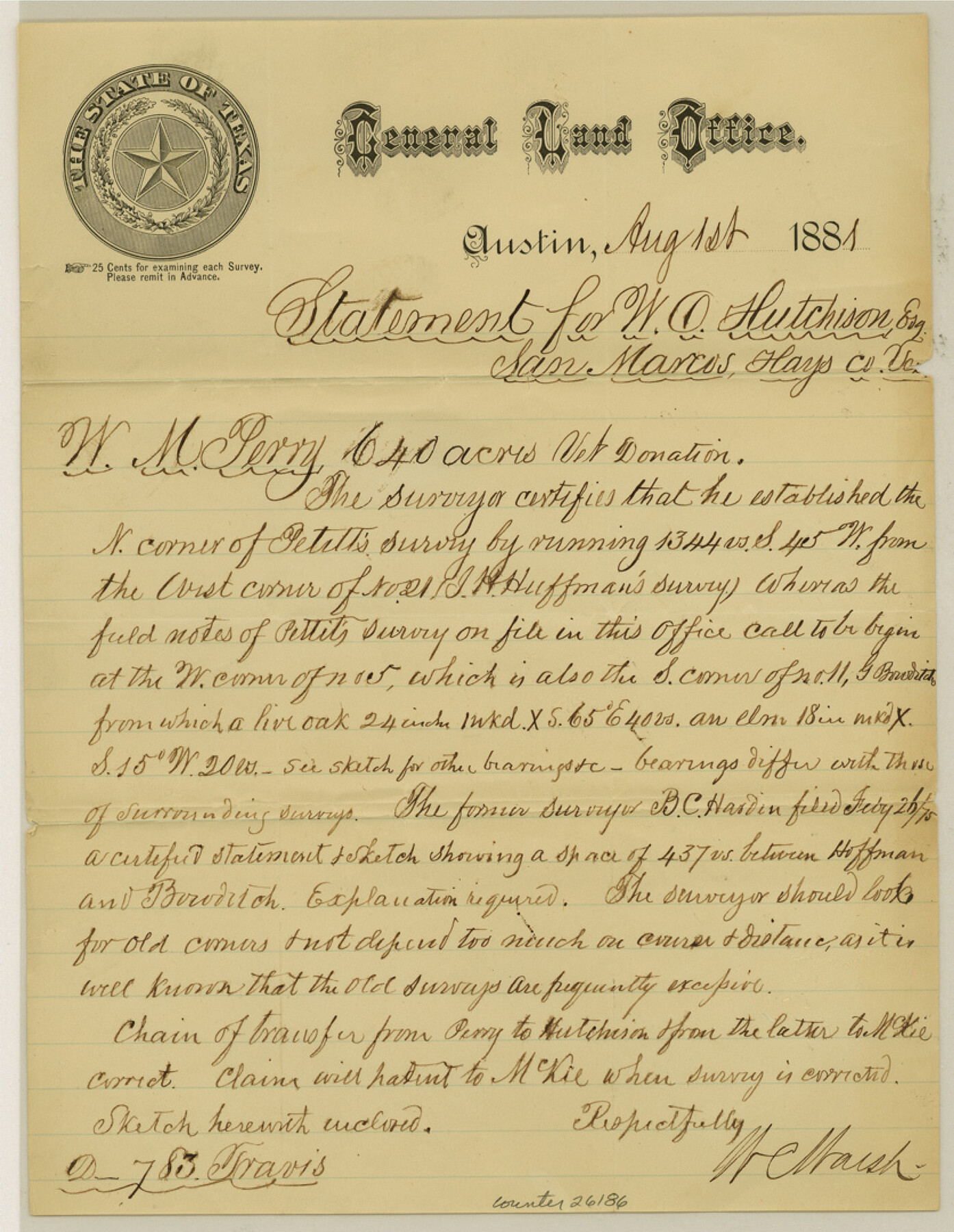
[Statement regarding north corner of Henry Pettit survey 5 and surrounding surveys]
-
Map/Doc
26186
-
Collection
General Map Collection
-
Object Dates
8/2/1881 (Creation Date)
8/1/1881 (Correspondence Date)
12/7/1883 (Creation Date)
-
People and Organizations
Hutchins (Surveyor/Engineer)
B.C. Hardin (Surveyor/Engineer)
W.C. Walsh (GLO Commissioner)
-
Counties
Hays Comal
-
Subjects
Surveying Sketch File
-
Height x Width
10.8 x 8.4 inches
27.4 x 21.3 cm
-
Medium
paper, manuscript
Part of: General Map Collection
Travis County Sketch File 71

Print $10.00
- Digital $50.00
Travis County Sketch File 71
1840
Size 12.9 x 8.3 inches
Map/Doc 38456
Kaufman County Sketch File 15

Print $26.00
- Digital $50.00
Kaufman County Sketch File 15
Size 8.5 x 8.2 inches
Map/Doc 28651
Hood County Sketch File 11

Print $20.00
- Digital $50.00
Hood County Sketch File 11
Size 17.5 x 16.2 inches
Map/Doc 11779
Intracoastal Waterway, Houma, LA to Corpus Christi, TX

Print $5.00
- Digital $50.00
Intracoastal Waterway, Houma, LA to Corpus Christi, TX
Size 22.3 x 28.0 inches
Map/Doc 61914
Nueces County Rolled Sketch 63A

Print $20.00
- Digital $50.00
Nueces County Rolled Sketch 63A
1979
Size 25.0 x 36.7 inches
Map/Doc 6910
Collin County Sketch File 13

Print $4.00
- Digital $50.00
Collin County Sketch File 13
1874
Size 8.8 x 6.8 inches
Map/Doc 18872
[Texas Gulf Coast]
![72677, [Texas Gulf Coast], General Map Collection](https://historictexasmaps.com/wmedia_w700/maps/72677.tif.jpg)
Print $20.00
- Digital $50.00
[Texas Gulf Coast]
Size 27.3 x 18.2 inches
Map/Doc 72677
Hill County Sketch File 24

Print $40.00
- Digital $50.00
Hill County Sketch File 24
Size 15.6 x 13.8 inches
Map/Doc 26516
McMullen County Rolled Sketch 14

Print $20.00
- Digital $50.00
McMullen County Rolled Sketch 14
1946
Size 33.3 x 41.0 inches
Map/Doc 6731
Leon County Rolled Sketch 17

Print $20.00
- Digital $50.00
Leon County Rolled Sketch 17
1981
Size 25.2 x 33.4 inches
Map/Doc 6602
Brazoria County Working Sketch 13

Print $20.00
- Digital $50.00
Brazoria County Working Sketch 13
1936
Size 21.5 x 33.1 inches
Map/Doc 78194
Marion County Working Sketch 18

Print $20.00
- Digital $50.00
Marion County Working Sketch 18
1957
Size 36.4 x 40.3 inches
Map/Doc 70794
You may also like
Coryell County Sketch File 25

Print $4.00
- Digital $50.00
Coryell County Sketch File 25
1873
Size 12.8 x 8.3 inches
Map/Doc 19391
[Sketch of part of Blks. 4, 6, B5, 2Z, M6, M8, and M13]
![89643, [Sketch of part of Blks. 4, 6, B5, 2Z, M6, M8, and M13], Twichell Survey Records](https://historictexasmaps.com/wmedia_w700/maps/89643-1.tif.jpg)
Print $40.00
- Digital $50.00
[Sketch of part of Blks. 4, 6, B5, 2Z, M6, M8, and M13]
Size 55.2 x 26.8 inches
Map/Doc 89643
Val Verde County Working Sketch 118

Print $40.00
- Digital $50.00
Val Verde County Working Sketch 118
2005
Size 29.6 x 50.0 inches
Map/Doc 83587
Presidio County Working Sketch 56

Print $20.00
- Digital $50.00
Presidio County Working Sketch 56
1955
Size 13.9 x 22.0 inches
Map/Doc 71733
General Highway Map, Martin County, Texas

Print $20.00
General Highway Map, Martin County, Texas
1940
Size 18.2 x 24.6 inches
Map/Doc 79185
Flight Mission No. CUI-1H, Frame 142, Milam County

Print $20.00
- Digital $50.00
Flight Mission No. CUI-1H, Frame 142, Milam County
1951
Size 18.5 x 22.2 inches
Map/Doc 86608

Working Sketch of Surveys in Kent & Scurry Counties Located South of Clairemont, Texas

Print $20.00
- Digital $50.00
Working Sketch of Surveys in Kent & Scurry Counties Located South of Clairemont, Texas
1947
Size 41.2 x 43.4 inches
Map/Doc 89861
Knox County Rolled Sketch 23

Print $20.00
- Digital $50.00
Knox County Rolled Sketch 23
1989
Size 34.4 x 29.0 inches
Map/Doc 76408
Flight Mission No. BQY-15M, Frame 21, Harris County

Print $20.00
- Digital $50.00
Flight Mission No. BQY-15M, Frame 21, Harris County
1953
Size 18.7 x 22.3 inches
Map/Doc 85319
Flight Mission No. CLL-1N, Frame 113, Willacy County

Print $20.00
- Digital $50.00
Flight Mission No. CLL-1N, Frame 113, Willacy County
1954
Size 18.3 x 22.0 inches
Map/Doc 87047
Hudspeth County Sketch File 16

Print $10.00
- Digital $50.00
Hudspeth County Sketch File 16
1925
Size 14.3 x 8.8 inches
Map/Doc 26948