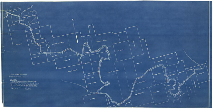
Smith County Rolled Sketch 6E1

Print $20.00
- Digital $50.00
Smith County Rolled Sketch 6E1
1966
Size: 27.4 x 22.7 inches
10612
Smith County Rolled Sketch 6E2

Print $20.00
- Digital $50.00
Smith County Rolled Sketch 6E2
1960
Size: 27.6 x 22.7 inches
10613
Smith County Rolled Sketch 6A3

Print $40.00
- Digital $50.00
Smith County Rolled Sketch 6A3
1990
Size: 48.6 x 36.8 inches
10698
Smith County Rolled Sketch 6

Print $20.00
- Digital $50.00
Smith County Rolled Sketch 6
1999
Size: 43.3 x 30.0 inches
10699
Smith County Rolled Sketch 6B

Print $40.00
- Digital $50.00
Smith County Rolled Sketch 6B
1949
Size: 91.7 x 38.5 inches
10700
Smith County Rolled Sketch 6C

Print $20.00
- Digital $50.00
Smith County Rolled Sketch 6C
1943
Size: 25.7 x 34.4 inches
10701
Smith County Rolled Sketch 6A2

Print $40.00
- Digital $50.00
Smith County Rolled Sketch 6A2
1934
Size: 48.7 x 36.7 inches
10702
Smith County Rolled Sketch 6D1

Print $20.00
- Digital $50.00
Smith County Rolled Sketch 6D1
Size: 24.7 x 24.7 inches
10703
Smith County Rolled Sketch 6A1

Print $40.00
- Digital $50.00
Smith County Rolled Sketch 6A1
Size: 49.2 x 38.6 inches
10704
Cherokee County Sketch File 9

Print $8.00
- Digital $50.00
Cherokee County Sketch File 9
1853
Size: 5.6 x 4.2 inches
18132
Cherokee County Sketch File 29

Print $2.00
- Digital $50.00
Cherokee County Sketch File 29
Size: 12.9 x 8.2 inches
18175
Gregg County Sketch File 1B

Print $4.00
- Digital $50.00
Gregg County Sketch File 1B
1848
Size: 12.8 x 8.4 inches
24538
Gregg County Sketch File 1G

Print $2.00
- Digital $50.00
Gregg County Sketch File 1G
Size: 6.2 x 7.0 inches
24549
Gregg County Sketch File 8

Print $28.00
- Digital $50.00
Gregg County Sketch File 8
1931
Size: 12.9 x 8.3 inches
24582
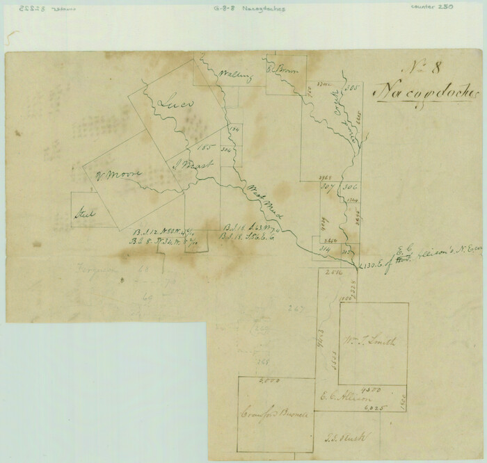
[Surveys along Mud Creek, Nacogdoches District]
Print $2.00
- Digital $50.00
[Surveys along Mud Creek, Nacogdoches District]
Size: 7.7 x 8.1 inches
250
Henderson County Sketch File 23

Print $38.00
- Digital $50.00
Henderson County Sketch File 23
1956
Size: 9.1 x 9.1 inches
26372
[Sketch for Mineral Application 26649-26650 - Sabine River, Harry A. Wolan]
Print $40.00
- Digital $50.00
[Sketch for Mineral Application 26649-26650 - Sabine River, Harry A. Wolan]
1931
Size: 36.9 x 72.2 inches
2852
Mud Creek in Nacogdoches District

Print $2.00
- Digital $50.00
Mud Creek in Nacogdoches District
1846
Size: 10.7 x 7.8 inches
345
Rusk County Sketch File 28

Print $24.00
Rusk County Sketch File 28
1937
Size: 11.4 x 8.7 inches
35542
Smith County Sketch File 1

Print $4.00
- Digital $50.00
Smith County Sketch File 1
Size: 9.0 x 10.5 inches
36746
Smith County Sketch File 2

Print $4.00
- Digital $50.00
Smith County Sketch File 2
1853
Size: 12.7 x 8.5 inches
36748
Smith County Sketch File 3

Print $4.00
- Digital $50.00
Smith County Sketch File 3
1853
Size: 10.5 x 8.6 inches
36750
Smith County Sketch File 4

Print $4.00
- Digital $50.00
Smith County Sketch File 4
1853
Size: 10.3 x 8.1 inches
36752
Smith County Sketch File 5

Print $6.00
- Digital $50.00
Smith County Sketch File 5
1857
Size: 8.4 x 7.8 inches
36754
Smith County Sketch File 6

Print $4.00
- Digital $50.00
Smith County Sketch File 6
1848
Size: 7.2 x 8.6 inches
36757
Smith County Sketch File 7

Print $4.00
- Digital $50.00
Smith County Sketch File 7
1848
Size: 12.7 x 8.2 inches
36759
Smith County Sketch File 8

Print $4.00
- Digital $50.00
Smith County Sketch File 8
1848
Size: 12.8 x 8.1 inches
36761
Smith County Sketch File 9

Print $6.00
- Digital $50.00
Smith County Sketch File 9
1848
Size: 16.2 x 10.4 inches
36763
Smith County Rolled Sketch 6E1
Print $20.00
- Digital $50.00
Smith County Rolled Sketch 6E1
1966
-
Size
27.4 x 22.7 inches
-
Map/Doc
10612
-
Creation Date
1966
Smith County Rolled Sketch 6E2
Print $20.00
- Digital $50.00
Smith County Rolled Sketch 6E2
1960
-
Size
27.6 x 22.7 inches
-
Map/Doc
10613
-
Creation Date
1960
Smith County Rolled Sketch 6A3
Print $40.00
- Digital $50.00
Smith County Rolled Sketch 6A3
1990
-
Size
48.6 x 36.8 inches
-
Map/Doc
10698
-
Creation Date
1990
Smith County Rolled Sketch 6
Print $20.00
- Digital $50.00
Smith County Rolled Sketch 6
1999
-
Size
43.3 x 30.0 inches
-
Map/Doc
10699
-
Creation Date
1999
Smith County Rolled Sketch 6B
Print $40.00
- Digital $50.00
Smith County Rolled Sketch 6B
1949
-
Size
91.7 x 38.5 inches
-
Map/Doc
10700
-
Creation Date
1949
Smith County Rolled Sketch 6C
Print $20.00
- Digital $50.00
Smith County Rolled Sketch 6C
1943
-
Size
25.7 x 34.4 inches
-
Map/Doc
10701
-
Creation Date
1943
Smith County Rolled Sketch 6A2
Print $40.00
- Digital $50.00
Smith County Rolled Sketch 6A2
1934
-
Size
48.7 x 36.7 inches
-
Map/Doc
10702
-
Creation Date
1934
Smith County Rolled Sketch 6D1
Print $20.00
- Digital $50.00
Smith County Rolled Sketch 6D1
-
Size
24.7 x 24.7 inches
-
Map/Doc
10703
Smith County Rolled Sketch 6A1
Print $40.00
- Digital $50.00
Smith County Rolled Sketch 6A1
-
Size
49.2 x 38.6 inches
-
Map/Doc
10704
Smith County

Print $20.00
- Digital $50.00
Smith County
1903
-
Size
45.1 x 41.1 inches
-
Map/Doc
16816
-
Creation Date
1903
Cherokee County Sketch File 9
Print $8.00
- Digital $50.00
Cherokee County Sketch File 9
1853
-
Size
5.6 x 4.2 inches
-
Map/Doc
18132
-
Creation Date
1853
Cherokee County Sketch File 29
Print $2.00
- Digital $50.00
Cherokee County Sketch File 29
-
Size
12.9 x 8.2 inches
-
Map/Doc
18175
Gregg County Sketch File 1B
Print $4.00
- Digital $50.00
Gregg County Sketch File 1B
1848
-
Size
12.8 x 8.4 inches
-
Map/Doc
24538
-
Creation Date
1848
Gregg County Sketch File 1G
Print $2.00
- Digital $50.00
Gregg County Sketch File 1G
-
Size
6.2 x 7.0 inches
-
Map/Doc
24549
Gregg County Sketch File 8
Print $28.00
- Digital $50.00
Gregg County Sketch File 8
1931
-
Size
12.9 x 8.3 inches
-
Map/Doc
24582
-
Creation Date
1931
[Surveys along Mud Creek, Nacogdoches District]
Print $2.00
- Digital $50.00
[Surveys along Mud Creek, Nacogdoches District]
-
Size
7.7 x 8.1 inches
-
Map/Doc
250
Henderson County Sketch File 23
Print $38.00
- Digital $50.00
Henderson County Sketch File 23
1956
-
Size
9.1 x 9.1 inches
-
Map/Doc
26372
-
Creation Date
1956
[Sketch for Mineral Application 26649-26650 - Sabine River, Harry A. Wolan]
Print $40.00
- Digital $50.00
[Sketch for Mineral Application 26649-26650 - Sabine River, Harry A. Wolan]
1931
-
Size
36.9 x 72.2 inches
-
Map/Doc
2852
-
Creation Date
1931
Mud Creek in Nacogdoches District
Print $2.00
- Digital $50.00
Mud Creek in Nacogdoches District
1846
-
Size
10.7 x 7.8 inches
-
Map/Doc
345
-
Creation Date
1846
Rusk County Sketch File 13

Print $4.00
Rusk County Sketch File 13
-
Size
8.6 x 6.4 inches
-
Map/Doc
35514
Rusk County Sketch File 28
Print $24.00
Rusk County Sketch File 28
1937
-
Size
11.4 x 8.7 inches
-
Map/Doc
35542
-
Creation Date
1937
Smith County Sketch File 1
Print $4.00
- Digital $50.00
Smith County Sketch File 1
-
Size
9.0 x 10.5 inches
-
Map/Doc
36746
Smith County Sketch File 2
Print $4.00
- Digital $50.00
Smith County Sketch File 2
1853
-
Size
12.7 x 8.5 inches
-
Map/Doc
36748
-
Creation Date
1853
Smith County Sketch File 3
Print $4.00
- Digital $50.00
Smith County Sketch File 3
1853
-
Size
10.5 x 8.6 inches
-
Map/Doc
36750
-
Creation Date
1853
Smith County Sketch File 4
Print $4.00
- Digital $50.00
Smith County Sketch File 4
1853
-
Size
10.3 x 8.1 inches
-
Map/Doc
36752
-
Creation Date
1853
Smith County Sketch File 5
Print $6.00
- Digital $50.00
Smith County Sketch File 5
1857
-
Size
8.4 x 7.8 inches
-
Map/Doc
36754
-
Creation Date
1857
Smith County Sketch File 6
Print $4.00
- Digital $50.00
Smith County Sketch File 6
1848
-
Size
7.2 x 8.6 inches
-
Map/Doc
36757
-
Creation Date
1848
Smith County Sketch File 7
Print $4.00
- Digital $50.00
Smith County Sketch File 7
1848
-
Size
12.7 x 8.2 inches
-
Map/Doc
36759
-
Creation Date
1848
Smith County Sketch File 8
Print $4.00
- Digital $50.00
Smith County Sketch File 8
1848
-
Size
12.8 x 8.1 inches
-
Map/Doc
36761
-
Creation Date
1848
Smith County Sketch File 9
Print $6.00
- Digital $50.00
Smith County Sketch File 9
1848
-
Size
16.2 x 10.4 inches
-
Map/Doc
36763
-
Creation Date
1848