Smith County Sketch File 8
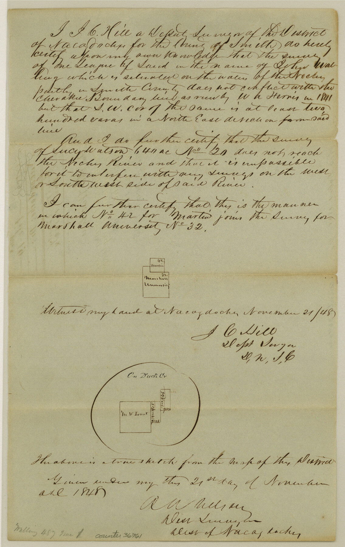
[Certificate of non-conflict of the John Walling league with other surveys and additional statements about other areas around the Marshall University survey and the M.V. Lout survey all in the northwest quadrant of the county]
-
Map/Doc
36761
-
Collection
General Map Collection
-
Object Dates
11/21/1848 (Creation Date)
12/1/1848 (File Date)
-
People and Organizations
J.C. Hill (Surveyor/Engineer)
A.A. Nelson (Surveyor/Engineer)
-
Counties
Smith Van Zandt
-
Subjects
Surveying Sketch File
-
Height x Width
12.8 x 8.1 inches
32.5 x 20.6 cm
-
Medium
paper, manuscript
-
Features
Neches River
Part of: General Map Collection
Jones County Sketch File 7

Print $20.00
- Digital $50.00
Jones County Sketch File 7
Size 12.5 x 27.5 inches
Map/Doc 11897
Val Verde County Sketch File Z19

Print $26.00
- Digital $50.00
Val Verde County Sketch File Z19
1912
Size 23.1 x 21.1 inches
Map/Doc 12559
Crockett County Sketch File 4

Print $6.00
- Digital $50.00
Crockett County Sketch File 4
Size 6.4 x 5.2 inches
Map/Doc 19649
Burnet County Working Sketch 24

Print $20.00
- Digital $50.00
Burnet County Working Sketch 24
1990
Size 19.9 x 26.8 inches
Map/Doc 67867
Flight Mission No. CUG-1P, Frame 69, Kleberg County

Print $20.00
- Digital $50.00
Flight Mission No. CUG-1P, Frame 69, Kleberg County
1956
Size 18.6 x 22.3 inches
Map/Doc 86134
Red River County Working Sketch 40

Print $20.00
- Digital $50.00
Red River County Working Sketch 40
1967
Size 40.1 x 35.9 inches
Map/Doc 72023
Old Miscellaneous File 8

Print $15.00
- Digital $50.00
Old Miscellaneous File 8
1853
Size 16.7 x 10.5 inches
Map/Doc 75427
Henderson County Rolled Sketch 1

Print $20.00
- Digital $50.00
Henderson County Rolled Sketch 1
1942
Size 34.0 x 38.3 inches
Map/Doc 9159
Morris County Rolled Sketch 2A

Print $20.00
- Digital $50.00
Morris County Rolled Sketch 2A
Size 24.0 x 18.7 inches
Map/Doc 10281
Flight Mission No. CGI-4N, Frame 194, Cameron County

Print $20.00
- Digital $50.00
Flight Mission No. CGI-4N, Frame 194, Cameron County
1955
Size 15.6 x 22.1 inches
Map/Doc 84697
Tyler County Working Sketch 12

Print $20.00
- Digital $50.00
Tyler County Working Sketch 12
1942
Size 21.2 x 31.7 inches
Map/Doc 69482
Houston County Working Sketch 32

Print $20.00
- Digital $50.00
Houston County Working Sketch 32
1987
Size 43.9 x 33.0 inches
Map/Doc 66262
You may also like
Van Zandt County Sketch File 27a

Print $22.00
- Digital $50.00
Van Zandt County Sketch File 27a
1894
Size 17.4 x 14.5 inches
Map/Doc 39449
Fannin County Sketch File 9

Print $20.00
- Digital $50.00
Fannin County Sketch File 9
Size 20.7 x 16.0 inches
Map/Doc 11470
Henderson County Working Sketch 37

Print $20.00
- Digital $50.00
Henderson County Working Sketch 37
1982
Size 29.4 x 22.0 inches
Map/Doc 66170
[Worksheets related to the Wilson Strickland survey and vicinity]
![91283, [Worksheets related to the Wilson Strickland survey and vicinity], Twichell Survey Records](https://historictexasmaps.com/wmedia_w700/maps/91283-1.tif.jpg)
Print $20.00
- Digital $50.00
[Worksheets related to the Wilson Strickland survey and vicinity]
Size 9.9 x 29.7 inches
Map/Doc 91283
Galveston County Rolled Sketch 51

Print $20.00
- Digital $50.00
Galveston County Rolled Sketch 51
2023
Size 24.1 x 35.6 inches
Map/Doc 97521
[Sketch of Survey 9, Block Z3]
![93091, [Sketch of Survey 9, Block Z3], Twichell Survey Records](https://historictexasmaps.com/wmedia_w700/maps/93091-1.tif.jpg)
Print $2.00
- Digital $50.00
[Sketch of Survey 9, Block Z3]
Size 7.0 x 6.9 inches
Map/Doc 93091
Brewster County Rolled Sketch 78

Print $20.00
- Digital $50.00
Brewster County Rolled Sketch 78
1945
Size 19.8 x 28.0 inches
Map/Doc 5243
Map of Cherokee Co.

Print $40.00
- Digital $50.00
Map of Cherokee Co.
1902
Size 59.7 x 39.6 inches
Map/Doc 4747
Kerr County Rolled Sketch 25

Print $20.00
- Digital $50.00
Kerr County Rolled Sketch 25
Size 24.7 x 31.0 inches
Map/Doc 6505
Coryell County Sketch File 23

Print $24.00
- Digital $50.00
Coryell County Sketch File 23
1948
Size 11.2 x 8.8 inches
Map/Doc 19387
Reeves County Working Sketch 56

Print $40.00
- Digital $50.00
Reeves County Working Sketch 56
1978
Size 58.8 x 29.5 inches
Map/Doc 63499
Approaches to Galveston Bay

Print $40.00
- Digital $50.00
Approaches to Galveston Bay
1986
Size 36.8 x 54.8 inches
Map/Doc 69886