Old Miscellaneous File 8
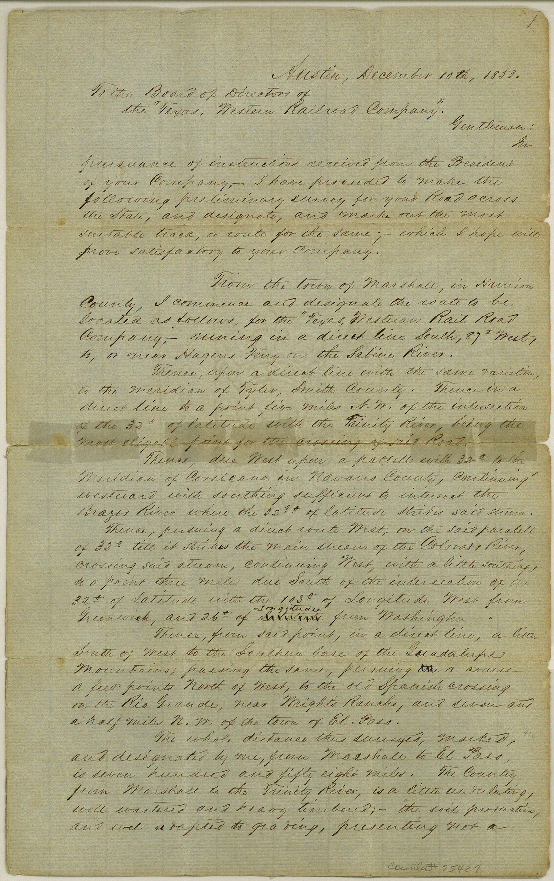
Letter and report regarding the route for the track of TW Ry Co. from Marshall to Rio Grande near El Paso
-
Map/Doc
75427
-
Collection
General Map Collection
-
Object Dates
1853 (Creation Date)
1853/12/17 (File Date)
-
People and Organizations
Richard M. Shinn (Author)
-
Subjects
Railroads
-
Height x Width
16.7 x 10.5 inches
42.4 x 26.7 cm
Part of: General Map Collection
Map of the State of Texas

Print $40.00
- Digital $50.00
Map of the State of Texas
1879
Size 47.1 x 51.4 inches
Map/Doc 2133
Hunt County Sketch File 38

Print $6.00
- Digital $50.00
Hunt County Sketch File 38
Size 11.0 x 10.8 inches
Map/Doc 27157
Tyler County Working Sketch 4

Print $20.00
- Digital $50.00
Tyler County Working Sketch 4
1926
Size 19.4 x 35.8 inches
Map/Doc 69474
Culberson County Rolled Sketch 34

Print $20.00
- Digital $50.00
Culberson County Rolled Sketch 34
1938
Size 43.5 x 43.6 inches
Map/Doc 8749
Harrison County Working Sketch 34

Print $20.00
- Digital $50.00
Harrison County Working Sketch 34
2015
Size 13.7 x 17.9 inches
Map/Doc 93726
[Surveys along the Sabine River made under G.W. Smyth, Commissioner]
![89, [Surveys along the Sabine River made under G.W. Smyth, Commissioner], General Map Collection](https://historictexasmaps.com/wmedia_w700/maps/89.tif.jpg)
Print $20.00
- Digital $50.00
[Surveys along the Sabine River made under G.W. Smyth, Commissioner]
Size 12.6 x 17.1 inches
Map/Doc 89
Brewster County Working Sketch 95

Print $40.00
- Digital $50.00
Brewster County Working Sketch 95
1975
Size 55.5 x 38.6 inches
Map/Doc 67695
Hopkins County Sketch File 24

Print $4.00
- Digital $50.00
Hopkins County Sketch File 24
1871
Size 12.8 x 8.4 inches
Map/Doc 26734
Map of Armstrong County

Print $20.00
- Digital $50.00
Map of Armstrong County
1881
Size 25.8 x 19.9 inches
Map/Doc 3243
Johnson County Working Sketch 28

Print $20.00
- Digital $50.00
Johnson County Working Sketch 28
2005
Size 24.0 x 26.0 inches
Map/Doc 84700
Flight Mission No. DCL-7C, Frame 66, Kenedy County

Print $20.00
- Digital $50.00
Flight Mission No. DCL-7C, Frame 66, Kenedy County
1943
Size 15.5 x 15.3 inches
Map/Doc 86052
Frio County Rolled Sketch 22

Print $20.00
- Digital $50.00
Frio County Rolled Sketch 22
1962
Size 16.4 x 24.6 inches
Map/Doc 5923
You may also like
The Mexican Department of Bexar. January 31, 1831

Print $20.00
The Mexican Department of Bexar. January 31, 1831
2020
Size 16.1 x 21.7 inches
Map/Doc 95968
Presidio County Rolled Sketch 70

Print $20.00
- Digital $50.00
Presidio County Rolled Sketch 70
1927
Size 37.1 x 13.9 inches
Map/Doc 7360
The Scarborough Company's New Railroad, Post Office & County Map of Texas, Oklahoma and Indian Territory Compiled from the Latest Government Surveys and Original Sources

Print $20.00
The Scarborough Company's New Railroad, Post Office & County Map of Texas, Oklahoma and Indian Territory Compiled from the Latest Government Surveys and Original Sources
1904
Size 43.1 x 47.8 inches
Map/Doc 93967
Presidio County Working Sketch 114

Print $40.00
- Digital $50.00
Presidio County Working Sketch 114
1981
Size 63.9 x 37.9 inches
Map/Doc 71791
Val Verde County Rolled Sketch 40

Print $40.00
- Digital $50.00
Val Verde County Rolled Sketch 40
Size 39.0 x 123.5 inches
Map/Doc 10073
Clason's Oil Map of Texas and Oklahoma showing the location and approximate area of the oil and gas fields

Print $20.00
- Digital $50.00
Clason's Oil Map of Texas and Oklahoma showing the location and approximate area of the oil and gas fields
1919
Size 22.4 x 24.5 inches
Map/Doc 97158
Dimmit County Sketch File 59

Print $26.00
- Digital $50.00
Dimmit County Sketch File 59
1912
Size 14.4 x 8.9 inches
Map/Doc 21193
McLennan County Sketch File 11

Print $8.00
- Digital $50.00
McLennan County Sketch File 11
1860
Size 9.0 x 7.7 inches
Map/Doc 31262
Crane County Sketch File 4

Print $6.00
- Digital $50.00
Crane County Sketch File 4
Size 13.6 x 10.9 inches
Map/Doc 19562
Bastrop County Working Sketch 14

Print $20.00
- Digital $50.00
Bastrop County Working Sketch 14
1984
Size 24.5 x 23.4 inches
Map/Doc 67314
Karnes County Boundary File 6

Print $16.00
- Digital $50.00
Karnes County Boundary File 6
Size 9.3 x 4.0 inches
Map/Doc 55735
Stonewall County Rolled Sketch 14

Print $20.00
- Digital $50.00
Stonewall County Rolled Sketch 14
1902
Size 32.9 x 25.2 inches
Map/Doc 7869