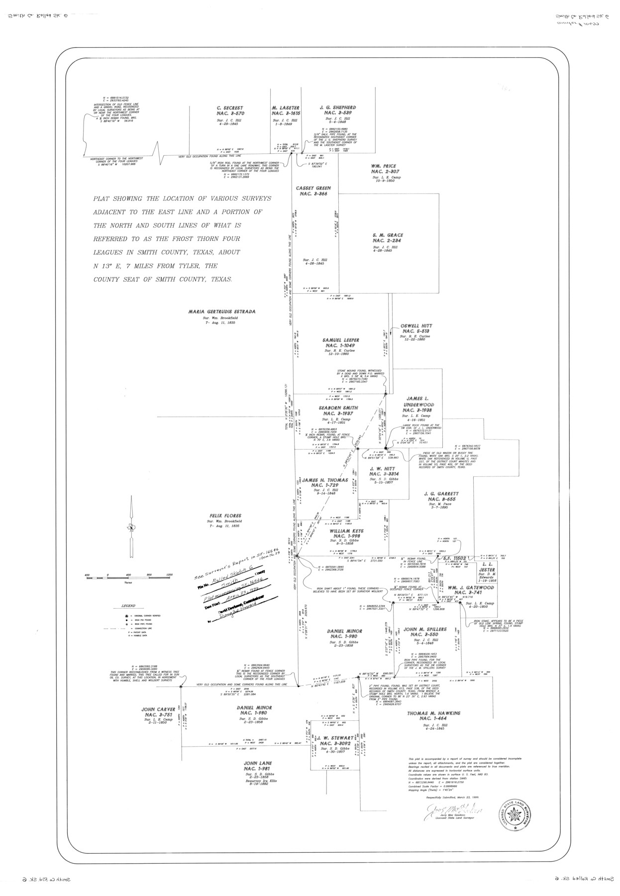
Smith County Rolled Sketch 6
Plat showing the location of various surveys adjacent to the east line and a portion of the north and south lines of what is referred to as the Frost Thorn four leagues in Smith County, Texas
-
Map/Doc
10699
-
Collection
General Map Collection
-
Object Dates
1999/3/23 (Creation Date)
1999/4/23 (File Date)
-
People and Organizations
Jerry Max Goodson (Surveyor/Engineer)
-
Counties
Smith
-
Subjects
Surveying Rolled Sketch
-
Height x Width
43.3 x 30.0 inches
110.0 x 76.2 cm
-
Medium
mylar, print
-
Comments
See surveyor's report in SF-16546. See Smith County Rolled Sketch 6A1 (10704) for related plat and see Smith County Rolled Sketch 6A2 (10702) and Smith County Rolled Sketch 6A3 (10698) for aerial photos.
Related maps
Smith County Rolled Sketch 6A3

Print $40.00
- Digital $50.00
Smith County Rolled Sketch 6A3
1990
Size 48.6 x 36.8 inches
Map/Doc 10698
Smith County Rolled Sketch 6A2

Print $40.00
- Digital $50.00
Smith County Rolled Sketch 6A2
1934
Size 48.7 x 36.7 inches
Map/Doc 10702
Smith County Rolled Sketch 6A1

Print $40.00
- Digital $50.00
Smith County Rolled Sketch 6A1
Size 49.2 x 38.6 inches
Map/Doc 10704
Part of: General Map Collection
Harris County Working Sketch 37

Print $20.00
- Digital $50.00
Harris County Working Sketch 37
1938
Size 25.4 x 28.0 inches
Map/Doc 65929
Falls County Sketch File 16

Print $8.00
- Digital $50.00
Falls County Sketch File 16
Size 13.3 x 8.5 inches
Map/Doc 22374
Township No. 6 South Range No. 9 West of the Indian Meridian

Print $20.00
- Digital $50.00
Township No. 6 South Range No. 9 West of the Indian Meridian
1874
Size 19.2 x 24.5 inches
Map/Doc 75166
Jeff Davis County Rolled Sketch 13A

Print $20.00
- Digital $50.00
Jeff Davis County Rolled Sketch 13A
1921
Size 19.0 x 23.1 inches
Map/Doc 6367
Kleberg County Aerial Photograph Index Sheet 6

Print $20.00
- Digital $50.00
Kleberg County Aerial Photograph Index Sheet 6
1956
Size 19.3 x 23.5 inches
Map/Doc 83723
Flight Mission No. CUG-1P, Frame 74, Kleberg County

Print $20.00
- Digital $50.00
Flight Mission No. CUG-1P, Frame 74, Kleberg County
1956
Size 18.5 x 22.3 inches
Map/Doc 86139
Dallas County Working Sketch 18

Print $20.00
- Digital $50.00
Dallas County Working Sketch 18
1989
Size 39.9 x 37.4 inches
Map/Doc 68584
[Bastrop District]
![3131, [Bastrop District], General Map Collection](https://historictexasmaps.com/wmedia_w700/maps/3131.tif.jpg)
Print $40.00
- Digital $50.00
[Bastrop District]
1895
Size 36.5 x 52.0 inches
Map/Doc 3131
Flight Mission No. DAG-24K, Frame 131, Matagorda County

Print $20.00
- Digital $50.00
Flight Mission No. DAG-24K, Frame 131, Matagorda County
1953
Size 18.6 x 22.4 inches
Map/Doc 86549
Gregg County Sketch File 1C

Print $6.00
- Digital $50.00
Gregg County Sketch File 1C
1847
Size 7.8 x 11.6 inches
Map/Doc 24540
Roberts County

Print $20.00
- Digital $50.00
Roberts County
1900
Size 43.4 x 42.0 inches
Map/Doc 63002
Dexter Quadrangle

Print $20.00
- Digital $50.00
Dexter Quadrangle
1999
Size 35.4 x 23.4 inches
Map/Doc 97361
You may also like
Tom Green County Boundary File 7

Print $10.00
- Digital $50.00
Tom Green County Boundary File 7
Size 14.5 x 9.2 inches
Map/Doc 59388
Flight Mission No. CGI-3N, Frame 142, Cameron County

Print $20.00
- Digital $50.00
Flight Mission No. CGI-3N, Frame 142, Cameron County
1954
Size 18.7 x 22.3 inches
Map/Doc 84615


Titus County Working Sketch 3

Print $20.00
- Digital $50.00
Titus County Working Sketch 3
Size 21.7 x 31.8 inches
Map/Doc 69364
Flight Mission No. BRE-1P, Frame 35, Nueces County

Print $20.00
- Digital $50.00
Flight Mission No. BRE-1P, Frame 35, Nueces County
1956
Size 18.4 x 22.2 inches
Map/Doc 86631
Sterling County Rolled Sketch 24

Print $20.00
- Digital $50.00
Sterling County Rolled Sketch 24
Size 25.8 x 19.6 inches
Map/Doc 7850
Hall County Sketch File 30

Print $6.00
- Digital $50.00
Hall County Sketch File 30
1942
Size 11.3 x 8.9 inches
Map/Doc 24832
Reagan County Working Sketch 45

Print $20.00
- Digital $50.00
Reagan County Working Sketch 45
1987
Size 30.1 x 43.1 inches
Map/Doc 71887

Flight Mission No. DAG-21K, Frame 125, Matagorda County

Print $20.00
- Digital $50.00
Flight Mission No. DAG-21K, Frame 125, Matagorda County
1952
Size 18.5 x 22.4 inches
Map/Doc 86451
Armstrong County Sketch File A-10

Print $40.00
- Digital $50.00
Armstrong County Sketch File A-10
Size 22.6 x 35.6 inches
Map/Doc 10852