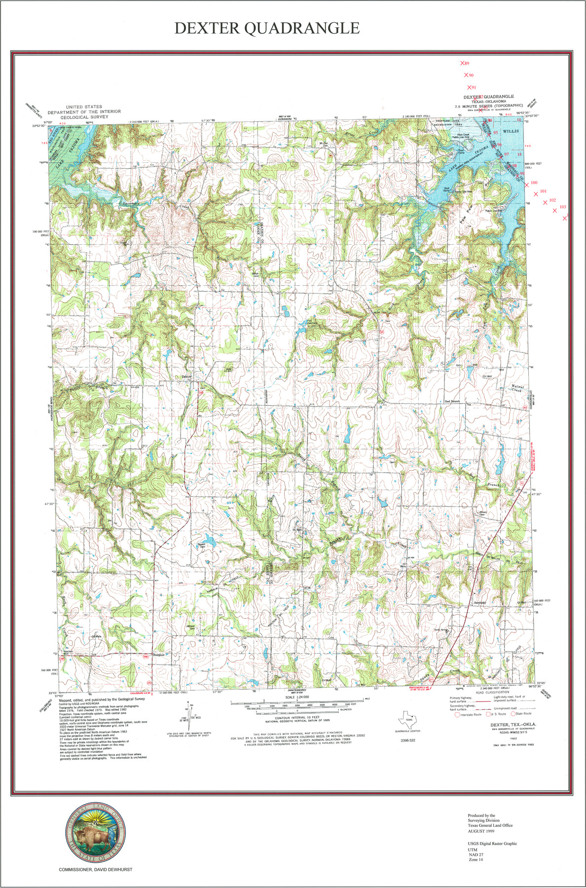
Dexter Quadrangle
USGS Topo Sheet showing plotted Texoma Area Boundary
-
Map/Doc
97361
-
Collection
General Map Collection
-
Object Dates
8/1999 (Creation Date)
-
Counties
Cooke Grayson
-
Subjects
Texas Boundaries Topographic
-
Height x Width
35.4 x 23.4 inches
89.9 x 59.4 cm
-
Comments
See Texas State Boundary Line 7 (75018) and Texas State Boundary Line 10 (97431) for copies of the Texoma Area Boundary Agreement.
Related maps
Texas State Boundary Line 7

Print $182.00
Texas State Boundary Line 7
2000
Size 11.2 x 8.8 inches
Map/Doc 75018
Texas State Boundary Line 8

Print $170.00
Texas State Boundary Line 8
2000
Size 11.3 x 8.8 inches
Map/Doc 75054
Texas State Boundary Line 9

Print $174.00
Texas State Boundary Line 9
2000
Size 11.3 x 8.8 inches
Map/Doc 75076
Lebanon Quadrangle

Print $20.00
- Digital $50.00
Lebanon Quadrangle
1999
Size 35.4 x 23.4 inches
Map/Doc 97360
Gordonville Quadrangle

Print $20.00
- Digital $50.00
Gordonville Quadrangle
1999
Size 35.4 x 23.4 inches
Map/Doc 97362
Pottsboro Quadrangle

Print $20.00
- Digital $50.00
Pottsboro Quadrangle
1999
Size 35.4 x 23.4 inches
Map/Doc 97363
Kingston South Quadrangle

Print $20.00
- Digital $50.00
Kingston South Quadrangle
1999
Size 35.4 x 23.4 inches
Map/Doc 97364
Platter Quadrangle

Print $20.00
- Digital $50.00
Platter Quadrangle
1999
Size 35.4 x 23.4 inches
Map/Doc 97365
Denison Dam Quadrangle

Print $20.00
- Digital $50.00
Denison Dam Quadrangle
1999
Size 35.4 x 23.4 inches
Map/Doc 97366

Part of: General Map Collection
Dallas County Rolled Sketch 3

Print $40.00
- Digital $50.00
Dallas County Rolled Sketch 3
1953
Size 30.7 x 78.5 inches
Map/Doc 8767
Collingsworth County Working Sketch 4

Print $20.00
- Digital $50.00
Collingsworth County Working Sketch 4
1960
Size 42.6 x 17.3 inches
Map/Doc 68092
Freestone County Working Sketch 18

Print $20.00
- Digital $50.00
Freestone County Working Sketch 18
1980
Size 43.3 x 46.9 inches
Map/Doc 69260
Cherokee County Working Sketch 3

Print $20.00
- Digital $50.00
Cherokee County Working Sketch 3
1934
Size 29.6 x 42.7 inches
Map/Doc 67958
Flight Mission No. BQY-4M, Frame 69, Harris County

Print $20.00
- Digital $50.00
Flight Mission No. BQY-4M, Frame 69, Harris County
1953
Size 18.6 x 22.4 inches
Map/Doc 85278
Mason County Sketch File 2

Print $22.00
- Digital $50.00
Mason County Sketch File 2
1847
Size 8.0 x 14.2 inches
Map/Doc 30680
Flight Mission No. CRC-3R, Frame 43, Chambers County

Print $20.00
- Digital $50.00
Flight Mission No. CRC-3R, Frame 43, Chambers County
1956
Size 18.5 x 22.3 inches
Map/Doc 84816
Duval County Working Sketch 42

Print $20.00
- Digital $50.00
Duval County Working Sketch 42
1976
Size 24.9 x 31.1 inches
Map/Doc 68766
Archer County Sketch File 8b

Print $42.00
- Digital $50.00
Archer County Sketch File 8b
1890
Map/Doc 88497
Rockwall County Working Sketch 2

Print $20.00
- Digital $50.00
Rockwall County Working Sketch 2
1923
Size 20.9 x 16.8 inches
Map/Doc 63594
[Galveston, Harrisburg & San Antonio through El Paso County]
![64002, [Galveston, Harrisburg & San Antonio through El Paso County], General Map Collection](https://historictexasmaps.com/wmedia_w700/maps/64002.tif.jpg)
Print $20.00
- Digital $50.00
[Galveston, Harrisburg & San Antonio through El Paso County]
1907
Size 13.6 x 33.9 inches
Map/Doc 64002
Houston Ship Channel, Alexander Island to Carpenter Bayou

Print $40.00
- Digital $50.00
Houston Ship Channel, Alexander Island to Carpenter Bayou
1992
Size 36.0 x 49.4 inches
Map/Doc 69918
You may also like
Midland County Sketch File 3

Print $20.00
- Digital $50.00
Midland County Sketch File 3
1886
Size 18.3 x 25.2 inches
Map/Doc 12081
Atascosa County Rolled Sketch 22

Print $40.00
- Digital $50.00
Atascosa County Rolled Sketch 22
1917
Size 25.9 x 57.4 inches
Map/Doc 8920
Delta County Sketch File 1

Print $4.00
- Digital $50.00
Delta County Sketch File 1
1871
Size 12.7 x 8.1 inches
Map/Doc 20666
A Map of North America, constructed according to the latest information

Print $40.00
- Digital $50.00
A Map of North America, constructed according to the latest information
1822
Size 44.4 x 59.6 inches
Map/Doc 93845
Map of the Rio Grande & Eagle Pass Ry. from Sections 1-6 Inclusive, Webb County

Print $40.00
- Digital $50.00
Map of the Rio Grande & Eagle Pass Ry. from Sections 1-6 Inclusive, Webb County
1909
Size 25.4 x 55.7 inches
Map/Doc 64655
Gray County Sketch File 12

Print $6.00
- Digital $50.00
Gray County Sketch File 12
1889
Size 17.0 x 8.3 inches
Map/Doc 24454
Right of Way and Track Map of The Wichita Falls & Southern Railroad Company

Print $40.00
- Digital $50.00
Right of Way and Track Map of The Wichita Falls & Southern Railroad Company
1942
Size 25.0 x 56.2 inches
Map/Doc 64520
[Atlas B, Table of Contents]
![78269, [Atlas B, Table of Contents], General Map Collection](https://historictexasmaps.com/wmedia_w700/maps/78269.tif.jpg)
Print $3.00
- Digital $50.00
[Atlas B, Table of Contents]
Size 10.3 x 9.6 inches
Map/Doc 78269
Flight Mission No. DAG-16K, Frame 71, Matagorda County

Print $20.00
- Digital $50.00
Flight Mission No. DAG-16K, Frame 71, Matagorda County
1952
Size 16.4 x 16.4 inches
Map/Doc 86317
Foard County Boundary File 2a

Print $40.00
- Digital $50.00
Foard County Boundary File 2a
Size 33.2 x 14.7 inches
Map/Doc 53514
Erath County Working Sketch 48

Print $20.00
- Digital $50.00
Erath County Working Sketch 48
1989
Size 36.5 x 47.6 inches
Map/Doc 69129
Calhoun County Working Sketch 1

Print $20.00
- Digital $50.00
Calhoun County Working Sketch 1
Size 28.3 x 33.7 inches
Map/Doc 67816