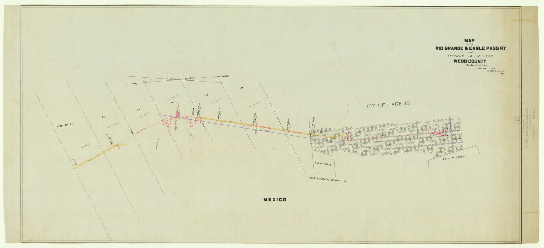
Map of the Rio Grande & Eagle Pass Ry. from Sections 1-6 Inclusive, Webb County
Z-2-13
-
Map/Doc
64655
-
Collection
General Map Collection
-
Object Dates
1909 (Creation Date)
-
People and Organizations
R. W. Davis (Surveyor/Engineer)
-
Counties
Webb
-
Subjects
Railroads
-
Height x Width
25.4 x 55.7 inches
64.5 x 141.5 cm
-
Medium
linen, manuscript
-
Scale
1" = 800 feet
-
Comments
From Sections 1 through 6.
See counter nos. 64656 through 64658 for other sections of the map. -
Features
RG&EP
Fort McIntosh
Laredo
I&GN
Dodd Spur
Cone Spur
Nye Spur
Davis Spur
Manadas Creek
Webb County Road
Pace Spur
Rio Grande
Part of: General Map Collection
Kent County Sketch File 12

Print $20.00
- Digital $50.00
Kent County Sketch File 12
1911
Size 26.8 x 23.6 inches
Map/Doc 11916

Flight Mission No. DIX-6P, Frame 185, Aransas County

Print $20.00
- Digital $50.00
Flight Mission No. DIX-6P, Frame 185, Aransas County
1956
Size 19.1 x 22.8 inches
Map/Doc 83847
Liberty County Working Sketch 67

Print $20.00
- Digital $50.00
Liberty County Working Sketch 67
1971
Size 35.3 x 44.5 inches
Map/Doc 70527
Flight Mission No. BRA-7M, Frame 184, Jefferson County

Print $20.00
- Digital $50.00
Flight Mission No. BRA-7M, Frame 184, Jefferson County
1953
Size 18.6 x 22.3 inches
Map/Doc 85552
Reeves County Rolled Sketch 22

Print $20.00
- Digital $50.00
Reeves County Rolled Sketch 22
1960
Size 40.8 x 20.9 inches
Map/Doc 7490
[Map of the Fort Worth & Denver City Ry., Dallam County, Texas]
![64351, [Map of the Fort Worth & Denver City Ry., Dallam County, Texas], General Map Collection](https://historictexasmaps.com/wmedia_w700/maps/64351.tif.jpg)
Print $40.00
- Digital $50.00
[Map of the Fort Worth & Denver City Ry., Dallam County, Texas]
1887
Size 21.1 x 121.0 inches
Map/Doc 64351
Wise County Sketch File 8

Print $4.00
- Digital $50.00
Wise County Sketch File 8
1855
Size 12.2 x 7.8 inches
Map/Doc 40537
Lynn County Rolled Sketch A

Print $20.00
- Digital $50.00
Lynn County Rolled Sketch A
1901
Size 33.5 x 34.2 inches
Map/Doc 9471
Medina County

Print $40.00
- Digital $50.00
Medina County
1915
Size 50.1 x 42.1 inches
Map/Doc 66924
Map of the Town of Harrold, Wilbarger County, Texas on the line of the Fort Worth and Denver City Railway

Print $20.00
- Digital $50.00
Map of the Town of Harrold, Wilbarger County, Texas on the line of the Fort Worth and Denver City Railway
1887
Size 31.2 x 28.6 inches
Map/Doc 2186
Colorado County Working Sketch 16

Print $20.00
- Digital $50.00
Colorado County Working Sketch 16
1950
Size 23.3 x 19.6 inches
Map/Doc 68116
You may also like
Oldham County Boundary File 3

Print $80.00
- Digital $50.00
Oldham County Boundary File 3
Size 20.0 x 58.0 inches
Map/Doc 57771
Eastland County Working Sketch 4

Print $20.00
- Digital $50.00
Eastland County Working Sketch 4
1918
Size 39.1 x 29.1 inches
Map/Doc 68785
Presidio County Rolled Sketch 56

Print $20.00
- Digital $50.00
Presidio County Rolled Sketch 56
1915
Size 21.8 x 17.1 inches
Map/Doc 7349
Map of Ellis County

Print $20.00
- Digital $50.00
Map of Ellis County
1871
Size 19.2 x 27.1 inches
Map/Doc 3509
Hays County Rolled Sketch 29

Print $20.00
- Digital $50.00
Hays County Rolled Sketch 29
1954
Size 26.1 x 28.0 inches
Map/Doc 6184
Sketch of coast of Texas, Laguna Madre from Pt. of Rocks to Corpus Christi [and accompanying letter]
![72962, Sketch of coast of Texas, Laguna Madre from Pt. of Rocks to Corpus Christi [and accompanying letter], General Map Collection](https://historictexasmaps.com/wmedia_w700/maps/72962.tif.jpg)
Print $20.00
- Digital $50.00
Sketch of coast of Texas, Laguna Madre from Pt. of Rocks to Corpus Christi [and accompanying letter]
1881
Size 26.5 x 18.3 inches
Map/Doc 72962
The Republic County of Jasper. Spring 1842

Print $20.00
The Republic County of Jasper. Spring 1842
2020
Size 19.5 x 21.7 inches
Map/Doc 96195
Leagues 35, 36, 37, 38, 39, 40, 41, and 42]
![92236, Leagues 35, 36, 37, 38, 39, 40, 41, and 42], Twichell Survey Records](https://historictexasmaps.com/wmedia_w700/maps/92236-1.tif.jpg)
Print $20.00
- Digital $50.00
Leagues 35, 36, 37, 38, 39, 40, 41, and 42]
Size 40.4 x 34.4 inches
Map/Doc 92236
Carta Particular de las Costas Setentrionales del Seno Mexicano que comprehende las de la Florída Ocidental las Márgenes de la Luisiana y toda la rivera que sigue por la Bahía de S. Bernardo y el Rio Bravo del Norte hasta la Laguna Madre

Carta Particular de las Costas Setentrionales del Seno Mexicano que comprehende las de la Florída Ocidental las Márgenes de la Luisiana y toda la rivera que sigue por la Bahía de S. Bernardo y el Rio Bravo del Norte hasta la Laguna Madre
1807
Size 27.3 x 40.3 inches
Map/Doc 94565
Hamilton County Working Sketch 19

Print $20.00
- Digital $50.00
Hamilton County Working Sketch 19
1953
Size 45.7 x 23.4 inches
Map/Doc 63357
Flight Mission No. BQR-7K, Frame 26, Brazoria County

Print $20.00
- Digital $50.00
Flight Mission No. BQR-7K, Frame 26, Brazoria County
1952
Size 18.7 x 22.3 inches
Map/Doc 84024
Starr County Working Sketch 24

Print $20.00
- Digital $50.00
Starr County Working Sketch 24
1988
Size 37.1 x 20.2 inches
Map/Doc 63940