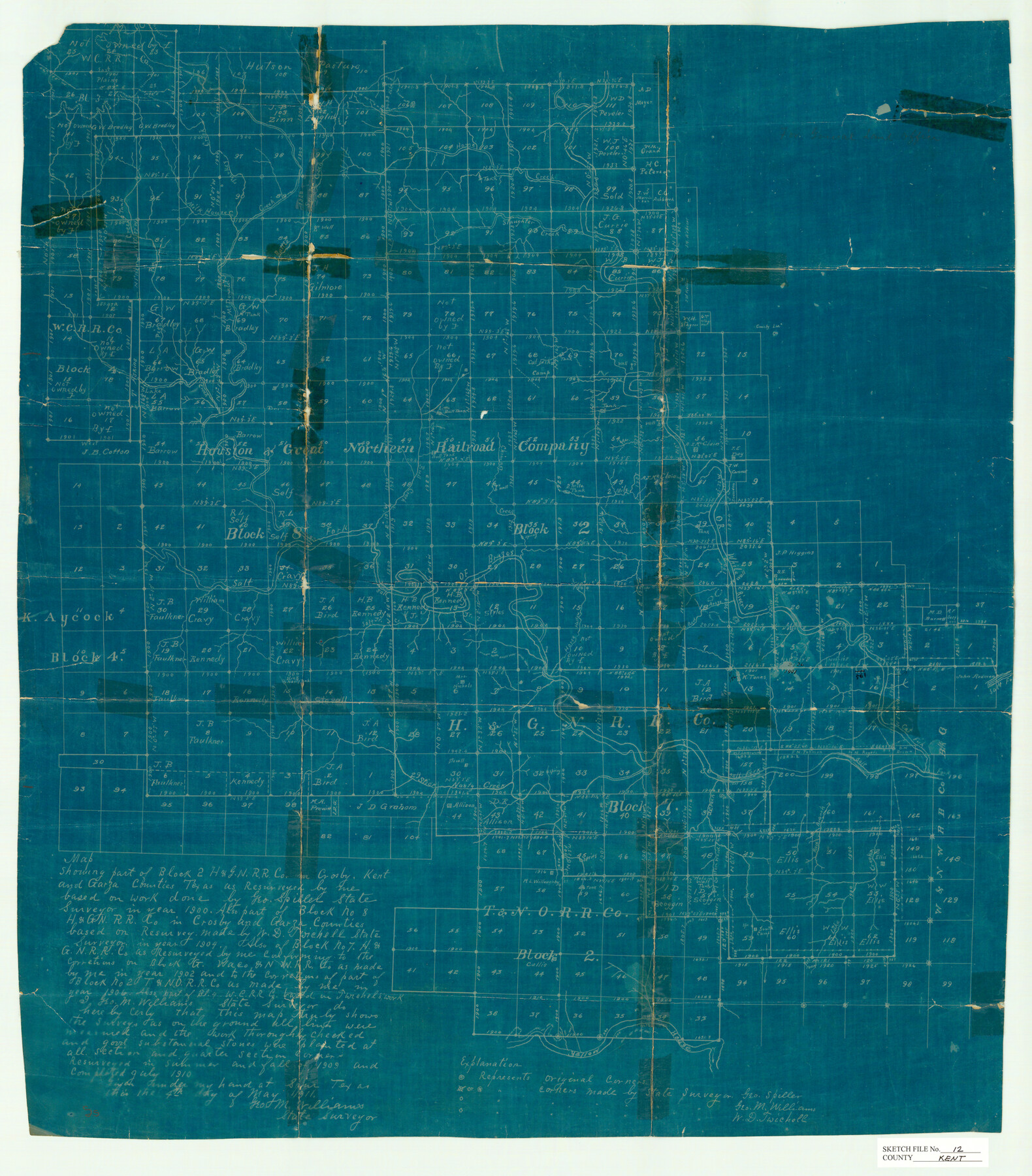
Kent County Sketch File 12
Map showing part of Block 2, H. & G. N. R.R. Co. in Crosby, Kent, and Garza Counties, Texas
-
Map/Doc
11916
-
Collection
General Map Collection
-
Object Dates
5/4/1911 (Creation Date)
1900 (Survey Date)
1904 (Survey Date)
-
People and Organizations
George M. Williams (Surveyor/Engineer)
George Spiller (Surveyor/Engineer)
W.D. Twichell (Surveyor/Engineer)
-
Counties
Kent Crosby Garza Dickens
-
Subjects
Surveying Sketch File
-
Height x Width
26.8 x 23.6 inches
68.1 x 59.9 cm
-
Medium
blueprint/diazo
-
Features
Home Creek
Slaughter Creek
Turkey Creek
Milk House Creek
Lake Creek
McDonald Creek
White River
Brazos River
Horse Hollow
Red Arroyo
Salt Creek
Brazos River
Salt Fork of Brazos River
Stick Nasty Creek
Yellow House River
Part of: General Map Collection
Clay County Sketch File 41

Print $6.00
- Digital $50.00
Clay County Sketch File 41
1949
Size 14.2 x 8.6 inches
Map/Doc 18482
King County Rolled Sketch 13

Print $40.00
- Digital $50.00
King County Rolled Sketch 13
Size 50.5 x 29.3 inches
Map/Doc 9353
Map of Falls County

Print $20.00
- Digital $50.00
Map of Falls County
1874
Size 20.3 x 21.5 inches
Map/Doc 3528
Amistad International Reservoir on Rio Grande 66

Print $20.00
- Digital $50.00
Amistad International Reservoir on Rio Grande 66
1949
Size 28.5 x 39.6 inches
Map/Doc 73351
Kimble County Sketch File 34

Print $20.00
- Digital $50.00
Kimble County Sketch File 34
1963
Size 26.2 x 16.3 inches
Map/Doc 11931
Right of Way and Track Map, International & Gt. Northern Ry. Operated by the International & Gt. Northern Ry. Co., Gulf Division

Print $40.00
- Digital $50.00
Right of Way and Track Map, International & Gt. Northern Ry. Operated by the International & Gt. Northern Ry. Co., Gulf Division
1917
Size 25.0 x 56.6 inches
Map/Doc 64249
Old Miscellaneous File 3

Print $4.00
- Digital $50.00
Old Miscellaneous File 3
1839
Size 8.8 x 8.2 inches
Map/Doc 75414
Controlled Mosaic by Jack Amman Photogrammetric Engineers, Inc - Sheet 41

Print $20.00
- Digital $50.00
Controlled Mosaic by Jack Amman Photogrammetric Engineers, Inc - Sheet 41
1954
Size 20.0 x 24.0 inches
Map/Doc 83496

[Map of Nacogdoches County]
![10784, [Map of Nacogdoches County], General Map Collection](https://historictexasmaps.com/wmedia_w700/maps/10784-1.tif.jpg)
Print $40.00
- Digital $50.00
[Map of Nacogdoches County]
1840
Size 79.3 x 69.8 inches
Map/Doc 10784
El Paso County Boundary File 14

Print $8.00
- Digital $50.00
El Paso County Boundary File 14
Size 13.0 x 8.6 inches
Map/Doc 53179
Bandera County Working Sketch 31

Print $20.00
- Digital $50.00
Bandera County Working Sketch 31
1955
Size 30.5 x 24.6 inches
Map/Doc 67627
You may also like
Ochiltree County Sketch File 3

Print $40.00
- Digital $50.00
Ochiltree County Sketch File 3
1908
Size 15.4 x 12.9 inches
Map/Doc 33177
El Paso County Rolled Sketch 57A

Print $40.00
- Digital $50.00
El Paso County Rolled Sketch 57A
1984
Size 49.2 x 39.4 inches
Map/Doc 8879
San Jacinto County Working Sketch 35

Print $20.00
- Digital $50.00
San Jacinto County Working Sketch 35
1955
Size 31.3 x 32.1 inches
Map/Doc 63748
Harris County Rolled Sketch 101

Print $20.00
- Digital $50.00
Harris County Rolled Sketch 101
2004
Size 24.3 x 36.2 inches
Map/Doc 83063
State Prison Lands Transferred to A&M College, Forest Division, Cherokee County

Print $4.00
- Digital $50.00
State Prison Lands Transferred to A&M College, Forest Division, Cherokee County
1932
Size 11.1 x 20.1 inches
Map/Doc 65086
Motley County Sketch File 8 (N)

Print $6.00
- Digital $50.00
Motley County Sketch File 8 (N)
1901
Size 13.2 x 8.1 inches
Map/Doc 32016
Gregg County Rolled Sketch 13

Print $64.00
- Digital $50.00
Gregg County Rolled Sketch 13
1940
Size 10.5 x 15.5 inches
Map/Doc 45439
Mason County Boundary File 2

Print $16.00
- Digital $50.00
Mason County Boundary File 2
Size 9.1 x 8.3 inches
Map/Doc 56830
Correct Map of the Railway & Steamship Lines operated by the Southern Pacific Company

Print $20.00
- Digital $50.00
Correct Map of the Railway & Steamship Lines operated by the Southern Pacific Company
1893
Size 16.7 x 40.1 inches
Map/Doc 95762
Freestone County Sketch File 22a

Print $20.00
- Digital $50.00
Freestone County Sketch File 22a
Size 17.8 x 18.1 inches
Map/Doc 11516
Kinney County Sketch File 23

Print $40.00
- Digital $50.00
Kinney County Sketch File 23
1901
Size 17.6 x 15.3 inches
Map/Doc 29162
[Hutchinson County Resurveys South of the Canadian River]
![91166, [Hutchinson County Resurveys South of the Canadian River], Twichell Survey Records](https://historictexasmaps.com/wmedia_w700/maps/91166-1.tif.jpg)
Print $20.00
- Digital $50.00
[Hutchinson County Resurveys South of the Canadian River]
1920
Size 33.3 x 21.1 inches
Map/Doc 91166