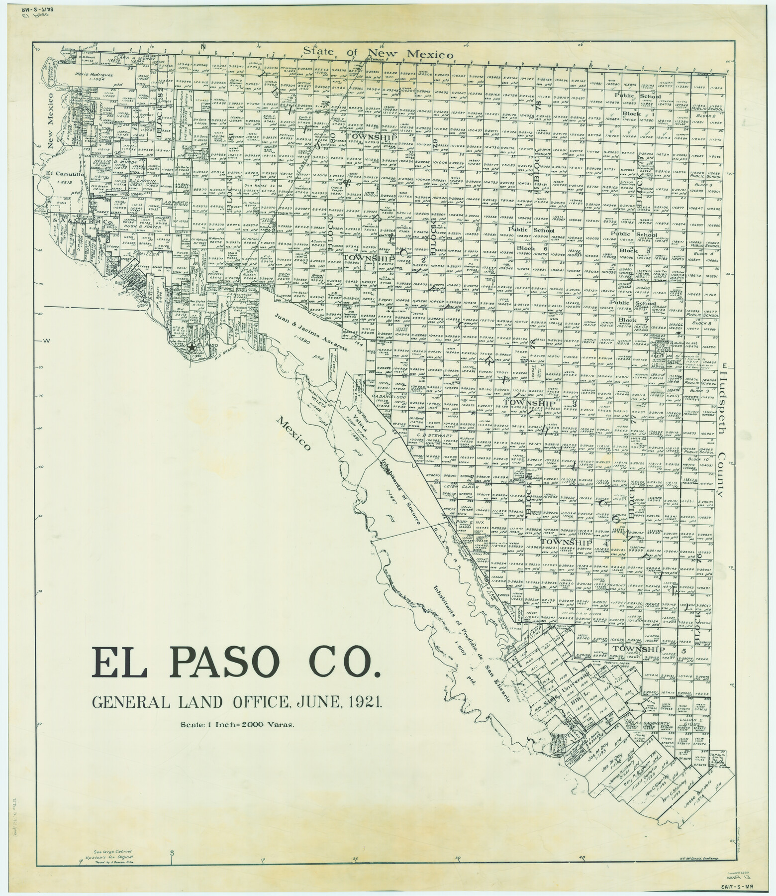
El Paso Co.
RM-2-71A3
-
Map/Doc
66817
-
Collection
General Map Collection
-
Object Dates
1921 (Creation Date)
-
People and Organizations
Texas General Land Office (Publisher)
H.F. McDonald (Compiler)
H.F. McDonald (Draftsman)
-
Counties
El Paso
-
Subjects
County
-
Height x Width
49.4 x 42.8 inches
125.5 x 108.7 cm
-
Comments
Traced by J. Bascom Giles.
Part of: General Map Collection
[Sketch for Mineral Application 33721 - 33725 Incl. - Padre and Mustang Island]
![2871, [Sketch for Mineral Application 33721 - 33725 Incl. - Padre and Mustang Island], General Map Collection](https://historictexasmaps.com/wmedia_w700/maps/2871.tif.jpg)
Print $20.00
- Digital $50.00
[Sketch for Mineral Application 33721 - 33725 Incl. - Padre and Mustang Island]
1942
Size 27.0 x 22.4 inches
Map/Doc 2871
A New Map of Texas with the contiguous American and Mexican States

Print $20.00
- Digital $50.00
A New Map of Texas with the contiguous American and Mexican States
1839
Size 13.0 x 15.4 inches
Map/Doc 96513
Sutton County Rolled Sketch 50

Print $40.00
- Digital $50.00
Sutton County Rolled Sketch 50
1950
Size 55.5 x 44.4 inches
Map/Doc 9975
Tyler County Working Sketch 10

Print $20.00
- Digital $50.00
Tyler County Working Sketch 10
1937
Size 24.0 x 24.1 inches
Map/Doc 69480
Fractional Township No. 7 South Range No. 20 East of the Indian Meridian, Indian Territory

Print $20.00
- Digital $50.00
Fractional Township No. 7 South Range No. 20 East of the Indian Meridian, Indian Territory
1897
Size 19.2 x 24.2 inches
Map/Doc 75236
Limestone County Working Sketch 19

Print $20.00
- Digital $50.00
Limestone County Working Sketch 19
1969
Size 37.1 x 29.7 inches
Map/Doc 70569
Presidio County Rolled Sketch 131A

Print $20.00
- Digital $50.00
Presidio County Rolled Sketch 131A
Size 25.5 x 26.3 inches
Map/Doc 10712
Flight Mission No. CGI-3N, Frame 139, Cameron County

Print $20.00
- Digital $50.00
Flight Mission No. CGI-3N, Frame 139, Cameron County
1954
Size 18.7 x 22.3 inches
Map/Doc 84612
DeWitt County Boundary File 1

Print $74.00
- Digital $50.00
DeWitt County Boundary File 1
Size 23.4 x 14.9 inches
Map/Doc 52479
Motley County Sketch File 1 (N)

Print $4.00
- Digital $50.00
Motley County Sketch File 1 (N)
Size 11.4 x 6.7 inches
Map/Doc 31994

Flight Mission No. CUG-2P, Frame 82, Kleberg County

Print $20.00
- Digital $50.00
Flight Mission No. CUG-2P, Frame 82, Kleberg County
1956
Size 18.5 x 22.3 inches
Map/Doc 86214
You may also like
Rough Working Sketch in Moore County

Print $20.00
- Digital $50.00
Rough Working Sketch in Moore County
Size 13.2 x 24.1 inches
Map/Doc 91414
South Sulphur River, Harpers Crossing Sheet

Print $20.00
- Digital $50.00
South Sulphur River, Harpers Crossing Sheet
1925
Size 23.3 x 18.0 inches
Map/Doc 78328
Kendall County Working Sketch 5

Print $20.00
- Digital $50.00
Kendall County Working Sketch 5
1946
Size 30.4 x 28.6 inches
Map/Doc 66677
Montgomery County Sketch File 39

Print $4.00
- Digital $50.00
Montgomery County Sketch File 39
1941
Size 14.6 x 8.6 inches
Map/Doc 31923
[Sketch showing County School Land Surveys in Throckmorton Counties, Texas]
![628, [Sketch showing County School Land Surveys in Throckmorton Counties, Texas], Maddox Collection](https://historictexasmaps.com/wmedia_w700/maps/628-GC.tif.jpg)
Print $20.00
- Digital $50.00
[Sketch showing County School Land Surveys in Throckmorton Counties, Texas]
1889
Size 15.9 x 20.2 inches
Map/Doc 628
San Jacinto Co.

Print $20.00
- Digital $50.00
San Jacinto Co.
1889
Size 46.4 x 37.9 inches
Map/Doc 63016
Ward County Sketch File 2

Print $40.00
- Digital $50.00
Ward County Sketch File 2
Size 25.0 x 62.7 inches
Map/Doc 10426
Texas and the Great War

Print $20.00
- Digital $50.00
Texas and the Great War
2017
Size 24.3 x 18.3 inches
Map/Doc 94412
McCulloch County Sketch File 15, 15a, 15b

Print $34.00
- Digital $50.00
McCulloch County Sketch File 15, 15a, 15b
1993
Size 11.2 x 8.8 inches
Map/Doc 31207
Dimmit County Rolled Sketch 17

Print $20.00
- Digital $50.00
Dimmit County Rolled Sketch 17
1974
Size 34.9 x 19.3 inches
Map/Doc 5724
Liberty County Rolled Sketch OB

Print $40.00
- Digital $50.00
Liberty County Rolled Sketch OB
1934
Size 71.0 x 24.8 inches
Map/Doc 9563
Bee County Working Sketch 8

Print $20.00
- Digital $50.00
Bee County Working Sketch 8
1939
Size 18.0 x 20.5 inches
Map/Doc 67258