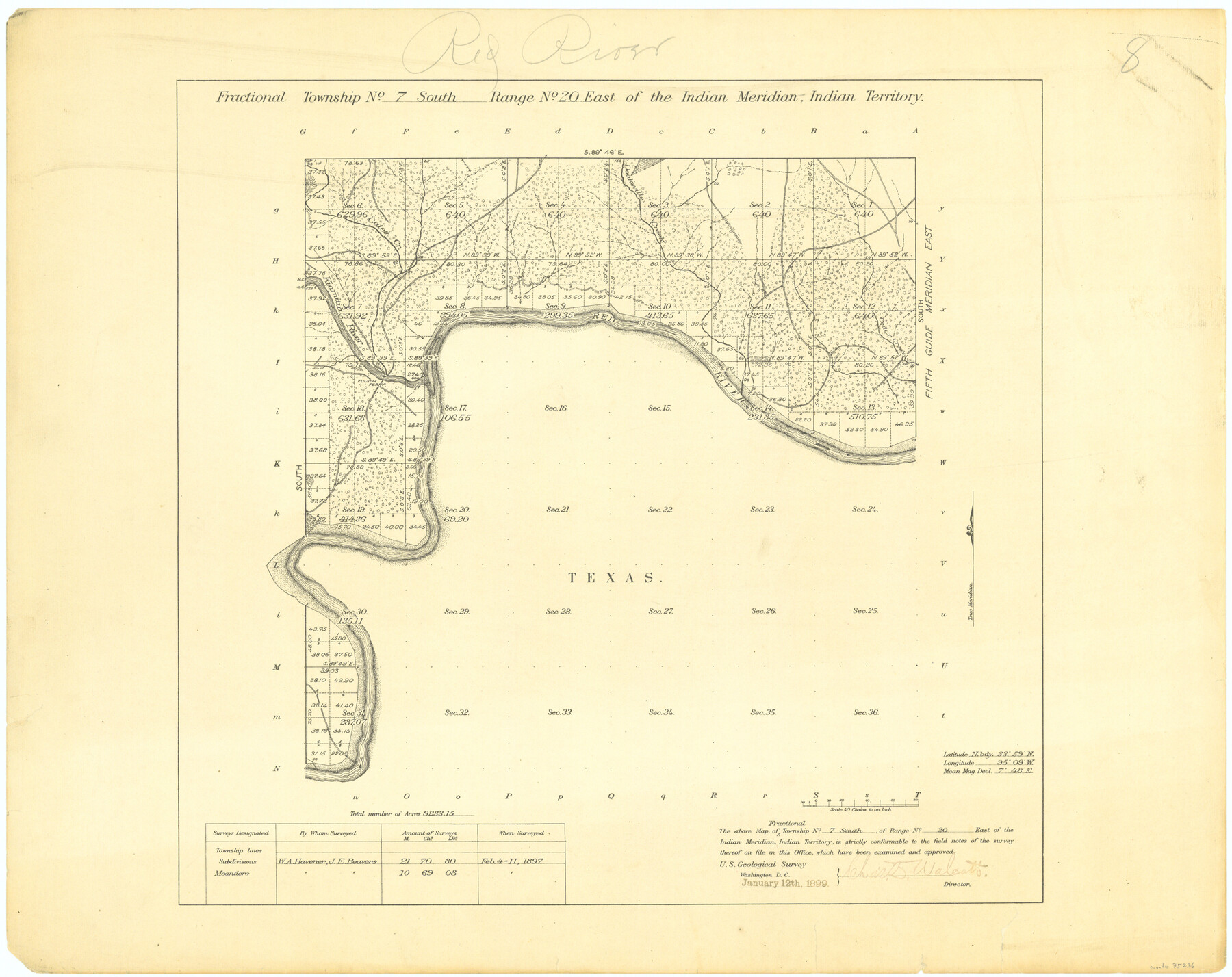
Fractional Township No. 7 South Range No. 20 East of the Indian Meridian, Indian Territory
-
Map/Doc
75236
-
Collection
General Map Collection
-
Object Dates
1897/2/11 (Creation Date)
-
Subjects
Texas Boundaries
-
Height x Width
19.2 x 24.2 inches
48.8 x 61.5 cm
Part of: General Map Collection
Van Zandt County Working Sketch 16

Print $20.00
- Digital $50.00
Van Zandt County Working Sketch 16
1991
Size 40.5 x 34.0 inches
Map/Doc 72266
Flight Mission No. CRC-5R, Frame 42, Chambers County

Print $20.00
- Digital $50.00
Flight Mission No. CRC-5R, Frame 42, Chambers County
1956
Size 18.6 x 22.3 inches
Map/Doc 84961

Pecos County Rolled Sketch 18

Print $20.00
- Digital $50.00
Pecos County Rolled Sketch 18
1882
Size 34.4 x 44.1 inches
Map/Doc 9683
Van Zandt County Boundary File 2a

Print $20.00
- Digital $50.00
Van Zandt County Boundary File 2a
Size 20.3 x 20.1 inches
Map/Doc 59649
Flight Mission No. BQR-9K, Frame 9, Brazoria County

Print $20.00
- Digital $50.00
Flight Mission No. BQR-9K, Frame 9, Brazoria County
1952
Size 18.6 x 22.3 inches
Map/Doc 84038
Brewster County Sketch File NS-6

Print $40.00
- Digital $50.00
Brewster County Sketch File NS-6
1944
Size 31.8 x 18.6 inches
Map/Doc 10989
Jeff Davis County Rolled Sketch 27

Print $20.00
- Digital $50.00
Jeff Davis County Rolled Sketch 27
1969
Size 29.3 x 36.8 inches
Map/Doc 6375
Flight Mission No. DQN-7K, Frame 34, Calhoun County

Print $20.00
- Digital $50.00
Flight Mission No. DQN-7K, Frame 34, Calhoun County
1953
Size 18.5 x 22.1 inches
Map/Doc 84472
Fayette County Boundary File 4

Print $19.00
- Digital $50.00
Fayette County Boundary File 4
Size 14.4 x 9.0 inches
Map/Doc 53362
Flight Mission No. DCL-6C, Frame 48, Kenedy County

Print $20.00
- Digital $50.00
Flight Mission No. DCL-6C, Frame 48, Kenedy County
1943
Size 18.7 x 22.3 inches
Map/Doc 85890
Panola County Working Sketch 5

Print $20.00
- Digital $50.00
Panola County Working Sketch 5
1940
Map/Doc 71414
You may also like
The Official Map of the City of El Paso, State of Texas

Print $40.00
The Official Map of the City of El Paso, State of Texas
1889
Size 83.6 x 97.2 inches
Map/Doc 89619
[Surveys in Vehlein's Colony along Long King's Creek]
![83, [Surveys in Vehlein's Colony along Long King's Creek], General Map Collection](https://historictexasmaps.com/wmedia_w700/maps/83.tif.jpg)
Print $20.00
- Digital $50.00
[Surveys in Vehlein's Colony along Long King's Creek]
Size 13.3 x 19.0 inches
Map/Doc 83
Montgomery Co.

Print $40.00
- Digital $50.00
Montgomery Co.
1943
Size 44.4 x 54.1 inches
Map/Doc 73244
Jeff Davis County Rolled Sketch 9

Print $20.00
- Digital $50.00
Jeff Davis County Rolled Sketch 9
Size 18.3 x 22.9 inches
Map/Doc 6362
Presidio County Sketch File 34

Print $4.00
- Digital $50.00
Presidio County Sketch File 34
1891
Size 14.3 x 8.7 inches
Map/Doc 34484
Flight Mission No. BQR-4K, Frame 58, Brazoria County

Print $20.00
- Digital $50.00
Flight Mission No. BQR-4K, Frame 58, Brazoria County
1952
Size 18.7 x 22.4 inches
Map/Doc 83991
Carte du Canada et de la Louisiane qui forment la Nouvelle France et des colonies angloises ou sont representez les pays contestez

Print $20.00
- Digital $50.00
Carte du Canada et de la Louisiane qui forment la Nouvelle France et des colonies angloises ou sont representez les pays contestez
1756
Size 21.5 x 29.6 inches
Map/Doc 97415
Denton County Sketch File AB

Print $8.00
- Digital $50.00
Denton County Sketch File AB
1896
Size 7.8 x 6.9 inches
Map/Doc 20677
Cameron County Rolled Sketch US

Print $20.00
- Digital $50.00
Cameron County Rolled Sketch US
1913
Size 31.1 x 26.3 inches
Map/Doc 5398
Location from Del Rio to Johnstone, Southern Pacific Railway Co.

Print $20.00
- Digital $50.00
Location from Del Rio to Johnstone, Southern Pacific Railway Co.
Size 13.3 x 44.3 inches
Map/Doc 64290
Presidio County Sketch File 74

Print $8.00
- Digital $50.00
Presidio County Sketch File 74
1946
Size 11.4 x 8.8 inches
Map/Doc 34687
Kinney County Working Sketch 42

Print $20.00
- Digital $50.00
Kinney County Working Sketch 42
1973
Size 20.4 x 33.7 inches
Map/Doc 70224