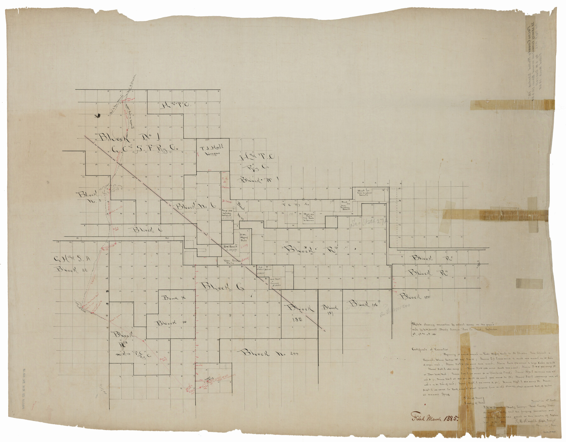
Pecos County Rolled Sketch 18
Sketch showing connection by actual survey on the ground [along border between Pecos and Brewster Counties]
-
Map/Doc
9683
-
Collection
General Map Collection
-
Object Dates
1882 (Creation Date)
1885 (File Date)
-
People and Organizations
L.W. Durrell (Surveyor/Engineer)
-
Counties
Pecos Brewster
-
Subjects
Surveying Rolled Sketch
-
Height x Width
34.4 x 44.1 inches
87.4 x 112.0 cm
-
Medium
linen, manuscript
Part of: General Map Collection
[County table portion of 1879 State of Texas map by Pressler & Langermann]
![3102, [County table portion of 1879 State of Texas map by Pressler & Langermann], General Map Collection](https://historictexasmaps.com/wmedia_w700/maps/3102-1.tif.jpg)
Print $20.00
- Digital $50.00
[County table portion of 1879 State of Texas map by Pressler & Langermann]
1879
Size 15.0 x 23.6 inches
Map/Doc 3102
Map of a part of the North Portion of Harris County

Print $40.00
- Digital $50.00
Map of a part of the North Portion of Harris County
Size 34.5 x 57.0 inches
Map/Doc 2049
Cottle County Rolled Sketch 7

Print $20.00
- Digital $50.00
Cottle County Rolled Sketch 7
Size 36.8 x 33.0 inches
Map/Doc 8675
Dickens County Sketch File 9

Print $4.00
- Digital $50.00
Dickens County Sketch File 9
Size 21.6 x 20.9 inches
Map/Doc 11319
Flight Mission No. CUG-2P, Frame 27, Kleberg County

Print $20.00
- Digital $50.00
Flight Mission No. CUG-2P, Frame 27, Kleberg County
1956
Size 18.9 x 22.5 inches
Map/Doc 86192
Zavala County Sketch File 26

Print $4.00
- Digital $50.00
Zavala County Sketch File 26
1886
Size 14.3 x 8.9 inches
Map/Doc 41390
Colorado River, Matagorda Sheet

Print $6.00
- Digital $50.00
Colorado River, Matagorda Sheet
1937
Size 30.9 x 35.8 inches
Map/Doc 65303
United States - Gulf Coast - From Latitude 26° 33' to the Rio Grande Texas

Print $20.00
- Digital $50.00
United States - Gulf Coast - From Latitude 26° 33' to the Rio Grande Texas
1913
Size 27.8 x 18.4 inches
Map/Doc 72831
Flight Mission No. BRE-2P, Frame 101, Nueces County

Print $20.00
- Digital $50.00
Flight Mission No. BRE-2P, Frame 101, Nueces County
1956
Size 18.4 x 22.2 inches
Map/Doc 86786
Runnels County Boundary File 1b

Print $24.00
- Digital $50.00
Runnels County Boundary File 1b
Size 15.7 x 8.3 inches
Map/Doc 58514
Kinney County Working Sketch 39

Print $20.00
- Digital $50.00
Kinney County Working Sketch 39
1972
Size 37.7 x 44.8 inches
Map/Doc 70221
Flight Mission No. BRE-1P, Frame 48, Nueces County

Print $20.00
- Digital $50.00
Flight Mission No. BRE-1P, Frame 48, Nueces County
1956
Size 18.4 x 22.1 inches
Map/Doc 86637
You may also like
General Highway Map, Collingsworth County, Texas

Print $20.00
General Highway Map, Collingsworth County, Texas
1940
Size 18.3 x 25.2 inches
Map/Doc 79053
Map of part of the Southern States to illustrate Olney's school geography

Print $20.00
- Digital $50.00
Map of part of the Southern States to illustrate Olney's school geography
1844
Size 12.1 x 19.0 inches
Map/Doc 93540
Mason County Sketch File 22

Print $8.00
- Digital $50.00
Mason County Sketch File 22
1932
Size 11.1 x 8.9 inches
Map/Doc 30719
Anderson County Working Sketch 22

Print $20.00
- Digital $50.00
Anderson County Working Sketch 22
1954
Size 22.7 x 24.2 inches
Map/Doc 67022
Polk County Working Sketch 6

Print $20.00
- Digital $50.00
Polk County Working Sketch 6
1933
Size 22.8 x 32.7 inches
Map/Doc 71621
Schleicher County Rolled Sketch 3

Print $20.00
- Digital $50.00
Schleicher County Rolled Sketch 3
1890
Size 41.5 x 31.2 inches
Map/Doc 8362
Mitchell's Travellers Guide Through the United States. A Map of the Roads, Distances, Steam Boat, and Canal Routes etc.

Print $20.00
Mitchell's Travellers Guide Through the United States. A Map of the Roads, Distances, Steam Boat, and Canal Routes etc.
1834
Size 18.2 x 22.6 inches
Map/Doc 79314
Jeff Davis County Rolled Sketch 6A

Print $20.00
- Digital $50.00
Jeff Davis County Rolled Sketch 6A
1889
Size 20.1 x 40.4 inches
Map/Doc 6361
Map of Burleson County, Texas

Print $20.00
- Digital $50.00
Map of Burleson County, Texas
1879
Size 16.1 x 21.1 inches
Map/Doc 667
Newton County Rolled Sketch 16

Print $20.00
- Digital $50.00
Newton County Rolled Sketch 16
Size 30.5 x 21.9 inches
Map/Doc 6846
Tarrant County Boundary File 1

Print $20.00
- Digital $50.00
Tarrant County Boundary File 1
Size 9.2 x 34.6 inches
Map/Doc 59110
Runnels County Rolled Sketch 44

Print $40.00
- Digital $50.00
Runnels County Rolled Sketch 44
Size 43.0 x 53.9 inches
Map/Doc 9871