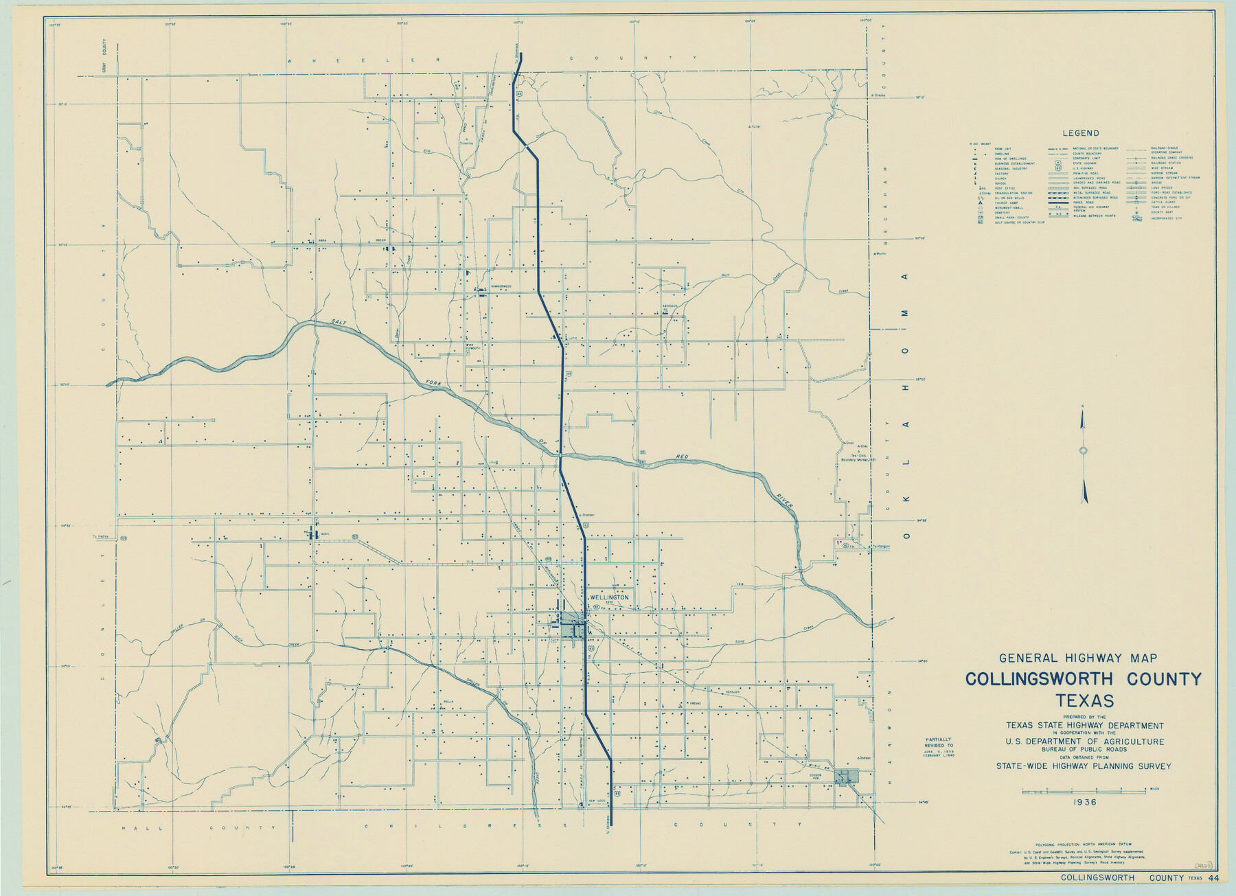
General Highway Map, Collingsworth County, Texas
-
Map/Doc
79053
-
Collection
Texas State Library and Archives
-
Object Dates
1940 (Creation Date)
-
People and Organizations
Texas State Highway Department (Publisher)
-
Counties
Collingsworth
-
Subjects
County
-
Height x Width
18.3 x 25.2 inches
46.5 x 64.0 cm
-
Comments
Prints available courtesy of the Texas State Library and Archives.
More info can be found here: TSLAC Map 04825
Part of: Texas State Library and Archives
Mitchell's Travellers Guide Through the United States. A Map of the Roads, Distances, Steam Boat, and Canal Routes etc.

Print $20.00
Mitchell's Travellers Guide Through the United States. A Map of the Roads, Distances, Steam Boat, and Canal Routes etc.
1835
Size 18.0 x 22.7 inches
Map/Doc 79723
Map of Texas compiled from surveys at the Land Office of Texas

Print $20.00
Map of Texas compiled from surveys at the Land Office of Texas
1851
Size 27.2 x 19.5 inches
Map/Doc 79748
Topographic Map of Texas and Oklahoma Boundary, Fort Augur Area

Print $20.00
Topographic Map of Texas and Oklahoma Boundary, Fort Augur Area
1924
Size 20.3 x 33.0 inches
Map/Doc 79753
General Highway Map, Cherokee County, Texas

Print $20.00
General Highway Map, Cherokee County, Texas
1961
Size 18.2 x 24.6 inches
Map/Doc 79405
General Highway Map, La Salle County, Texas

Print $20.00
General Highway Map, La Salle County, Texas
1961
Size 18.2 x 24.8 inches
Map/Doc 79565
Revised Map of Austin, Texas

Print $20.00
Revised Map of Austin, Texas
1885
Size 16.5 x 14.0 inches
Map/Doc 76272
General Highway Map, Aransas County, Texas

Print $20.00
General Highway Map, Aransas County, Texas
1940
Size 18.4 x 25.0 inches
Map/Doc 79004
General Highway Map, Panola County, Texas

Print $20.00
General Highway Map, Panola County, Texas
1961
Size 18.1 x 24.5 inches
Map/Doc 79624
General Highway Map, Fannin County, Texas

Print $20.00
General Highway Map, Fannin County, Texas
1940
Size 24.9 x 18.5 inches
Map/Doc 79087
General Highway Map. Detail of Cities and Towns in Hale County, Texas [Plainview and vicinity]
![79109, General Highway Map. Detail of Cities and Towns in Hale County, Texas [Plainview and vicinity], Texas State Library and Archives](https://historictexasmaps.com/wmedia_w700/maps/79109.tif.jpg)
Print $20.00
General Highway Map. Detail of Cities and Towns in Hale County, Texas [Plainview and vicinity]
1940
Size 25.0 x 18.5 inches
Map/Doc 79109
General Highway Map, Hood County, Somervell County, Texas

Print $20.00
General Highway Map, Hood County, Somervell County, Texas
1961
Size 18.1 x 24.6 inches
Map/Doc 79523
General Highway Map. Detail of Cities and Towns in Nacogdoches County, Texas [Nacogdoches and vicinity]
![79609, General Highway Map. Detail of Cities and Towns in Nacogdoches County, Texas [Nacogdoches and vicinity], Texas State Library and Archives](https://historictexasmaps.com/wmedia_w700/maps/79609.tif.jpg)
Print $20.00
General Highway Map. Detail of Cities and Towns in Nacogdoches County, Texas [Nacogdoches and vicinity]
1961
Size 19.3 x 25.0 inches
Map/Doc 79609
You may also like
San Antonio - Places of Interest and how to get there

San Antonio - Places of Interest and how to get there
1920
Map/Doc 96785
La Salle County Working Sketch 35

Print $20.00
- Digital $50.00
La Salle County Working Sketch 35
1958
Size 31.4 x 16.8 inches
Map/Doc 70336
Randall County Boundary File 5a

Print $8.00
- Digital $50.00
Randall County Boundary File 5a
Size 14.3 x 8.8 inches
Map/Doc 58141
Ward County Working Sketch 29

Print $40.00
- Digital $50.00
Ward County Working Sketch 29
1964
Size 49.3 x 26.9 inches
Map/Doc 72335

[Surveys along the San Marcos River]
![152, [Surveys along the San Marcos River], General Map Collection](https://historictexasmaps.com/wmedia_w700/maps/152.tif.jpg)
Print $2.00
- Digital $50.00
[Surveys along the San Marcos River]
Size 9.6 x 8.0 inches
Map/Doc 152
Reeves County Working Sketch 51

Print $20.00
- Digital $50.00
Reeves County Working Sketch 51
1974
Size 45.4 x 34.6 inches
Map/Doc 63494
Shelby County Working Sketch 5

Print $20.00
- Digital $50.00
Shelby County Working Sketch 5
1941
Size 40.6 x 40.8 inches
Map/Doc 63858
Webb County Rolled Sketch 2

Print $20.00
- Digital $50.00
Webb County Rolled Sketch 2
1881
Size 19.4 x 27.6 inches
Map/Doc 8169
Nouvelle Carte du Mexique du Texas et d'une partie des états limitrophes

Print $20.00
- Digital $50.00
Nouvelle Carte du Mexique du Texas et d'une partie des états limitrophes
1834
Size 39.9 x 27.4 inches
Map/Doc 94098

Crosby County Sketch File 10

Print $12.00
- Digital $50.00
Crosby County Sketch File 10
1887
Size 12.8 x 8.2 inches
Map/Doc 20011