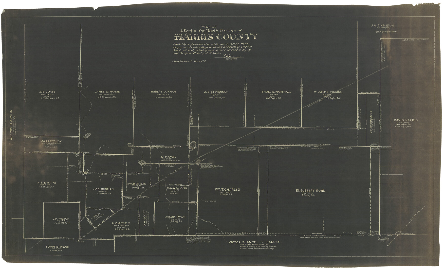
Map of a part of the North Portion of Harris County
K-3-3
-
Map/Doc
2049
-
Collection
General Map Collection
-
People and Organizations
L.A. Gueringer (Surveyor/Engineer)
-
Counties
Harris
-
Subjects
County
-
Height x Width
34.5 x 57.0 inches
87.6 x 144.8 cm
Part of: General Map Collection
Coke County Boundary File 3

Print $18.00
- Digital $50.00
Coke County Boundary File 3
Size 8.6 x 4.0 inches
Map/Doc 51584
Dallas County Boundary File 4a

Print $60.00
- Digital $50.00
Dallas County Boundary File 4a
Size 14.0 x 8.4 inches
Map/Doc 52142
Matagorda County Rolled Sketch 35

Print $20.00
- Digital $50.00
Matagorda County Rolled Sketch 35
1903
Size 18.6 x 38.0 inches
Map/Doc 6696
Hays County Working Sketch Graphic Index

Print $20.00
- Digital $50.00
Hays County Working Sketch Graphic Index
1946
Size 43.7 x 40.9 inches
Map/Doc 76573
Gray County Boundary File 2

Print $8.00
- Digital $50.00
Gray County Boundary File 2
Size 14.2 x 8.6 inches
Map/Doc 53850
Burnet County Sketch File 23

Print $8.00
- Digital $50.00
Burnet County Sketch File 23
1853
Size 9.0 x 10.9 inches
Map/Doc 16718
Floyd County Sketch File 27

Print $6.00
- Digital $50.00
Floyd County Sketch File 27
1900
Size 14.4 x 8.9 inches
Map/Doc 22789
Lipscomb County Rolled Sketch 5

Print $40.00
- Digital $50.00
Lipscomb County Rolled Sketch 5
Size 64.2 x 9.0 inches
Map/Doc 81428
Lynn County Rolled Sketch A

Print $20.00
- Digital $50.00
Lynn County Rolled Sketch A
1901
Size 33.5 x 34.2 inches
Map/Doc 9471
Deaf Smith County Sketch File 1 1/2

Print $20.00
- Digital $50.00
Deaf Smith County Sketch File 1 1/2
Size 20.7 x 17.1 inches
Map/Doc 11302
Flight Mission No. BRA-8M, Frame 120, Jefferson County

Print $20.00
- Digital $50.00
Flight Mission No. BRA-8M, Frame 120, Jefferson County
1953
Size 18.6 x 22.5 inches
Map/Doc 85616
Plan of the City of Galveston, Texas

Print $20.00
- Digital $50.00
Plan of the City of Galveston, Texas
1845
Size 18.3 x 27.4 inches
Map/Doc 62968
You may also like
Bell County Working Sketch 5

Print $20.00
- Digital $50.00
Bell County Working Sketch 5
1942
Size 26.9 x 21.0 inches
Map/Doc 67345
Flight Mission No. DAG-23K, Frame 14, Matagorda County

Print $20.00
- Digital $50.00
Flight Mission No. DAG-23K, Frame 14, Matagorda County
1953
Size 15.6 x 15.5 inches
Map/Doc 86476
General Road Map, Webb County, Texas

Print $40.00
- Digital $50.00
General Road Map, Webb County, Texas
1944
Size 37.1 x 50.0 inches
Map/Doc 10126
Sketch showing Mineral Leases in Nueces Bay

Print $20.00
- Digital $50.00
Sketch showing Mineral Leases in Nueces Bay
1942
Size 14.3 x 24.3 inches
Map/Doc 3019
Reagan County Working Sketch 7

Print $20.00
- Digital $50.00
Reagan County Working Sketch 7
1939
Size 29.6 x 30.5 inches
Map/Doc 71847
Flight Mission No. DCL-7C, Frame 29, Kenedy County

Print $20.00
- Digital $50.00
Flight Mission No. DCL-7C, Frame 29, Kenedy County
1943
Size 15.3 x 15.2 inches
Map/Doc 86021
Crosby County Working Sketch 1

Print $20.00
- Digital $50.00
Crosby County Working Sketch 1
Size 28.0 x 26.0 inches
Map/Doc 68435
General Highway Map, Atascosa County, Texas

Print $20.00
General Highway Map, Atascosa County, Texas
1961
Size 18.3 x 25.0 inches
Map/Doc 79355
Hutchinson County Rolled Sketch 43

Print $40.00
- Digital $50.00
Hutchinson County Rolled Sketch 43
1992
Size 40.6 x 49.9 inches
Map/Doc 6315
Galveston County NRC Article 33.136 Sketch 77

Print $44.00
- Digital $50.00
Galveston County NRC Article 33.136 Sketch 77
2015
Size 24.0 x 36.0 inches
Map/Doc 94991
Delta County Working Sketch Graphic Index

Print $20.00
- Digital $50.00
Delta County Working Sketch Graphic Index
1942
Size 25.3 x 39.2 inches
Map/Doc 76520
Cooke County Sketch File 7

Print $8.00
- Digital $50.00
Cooke County Sketch File 7
1855
Size 10.8 x 8.3 inches
Map/Doc 19231