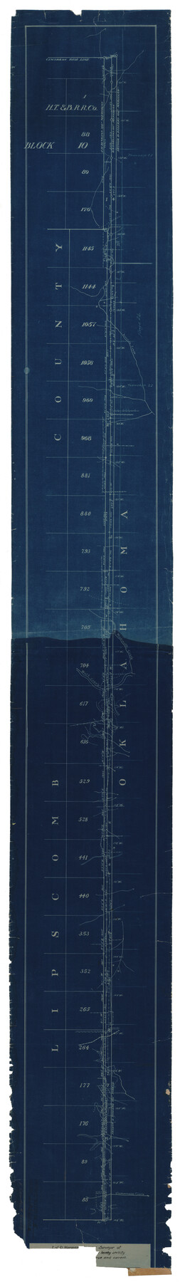
Lipscomb County Rolled Sketch 5
[Sketch of strip between Lipscomb County and Oklahoma]
-
Map/Doc
81428
-
Collection
General Map Collection
-
People and Organizations
J.D. Norman (Surveyor/Engineer)
-
Counties
Lipscomb
-
Subjects
Surveying Rolled Sketch
-
Height x Width
64.2 x 9.0 inches
163.1 x 22.9 cm
-
Medium
blueprint/diazo
Part of: General Map Collection
Gonzales County Working Sketch 12

Print $20.00
- Digital $50.00
Gonzales County Working Sketch 12
1981
Size 13.1 x 11.9 inches
Map/Doc 63228
Street guide and metropolitan map of New Orleans [Recto]
![94198, Street guide and metropolitan map of New Orleans [Recto], General Map Collection](https://historictexasmaps.com/wmedia_w700/maps/94198.tif.jpg)
Street guide and metropolitan map of New Orleans [Recto]
1963
Size 18.3 x 27.2 inches
Map/Doc 94198
Donley County Sketch File 1a

Print $20.00
- Digital $50.00
Donley County Sketch File 1a
Size 23.6 x 16.6 inches
Map/Doc 11362
Flight Mission No. DCL-6C, Frame 126, Kenedy County

Print $20.00
- Digital $50.00
Flight Mission No. DCL-6C, Frame 126, Kenedy County
1943
Size 18.5 x 22.3 inches
Map/Doc 85956
[St. Louis & Southwestern]
![64275, [St. Louis & Southwestern], General Map Collection](https://historictexasmaps.com/wmedia_w700/maps/64275.tif.jpg)
Print $20.00
- Digital $50.00
[St. Louis & Southwestern]
Size 20.8 x 28.6 inches
Map/Doc 64275
Webb County Sketch File 15-1

Print $20.00
- Digital $50.00
Webb County Sketch File 15-1
1935
Size 35.0 x 25.2 inches
Map/Doc 12634
Fort Bend County Working Sketch 20

Print $20.00
- Digital $50.00
Fort Bend County Working Sketch 20
1967
Size 22.4 x 33.4 inches
Map/Doc 69226
Webb County Working Sketch 1

Print $20.00
- Digital $50.00
Webb County Working Sketch 1
Size 15.6 x 14.4 inches
Map/Doc 72366
Edwards County Working Sketch 58

Print $20.00
- Digital $50.00
Edwards County Working Sketch 58
1953
Size 22.4 x 29.8 inches
Map/Doc 68934
Randall County Sketch File 4

Print $20.00
- Digital $50.00
Randall County Sketch File 4
1903
Size 35.6 x 13.4 inches
Map/Doc 12207
Hardin County Working Sketch 10

Print $20.00
- Digital $50.00
Hardin County Working Sketch 10
1929
Size 24.0 x 25.3 inches
Map/Doc 63408
Coleman County Sketch File 24a

Print $6.00
- Digital $50.00
Coleman County Sketch File 24a
1872
Size 10.2 x 15.9 inches
Map/Doc 18708
You may also like
Gonzales County Working Sketch 3

Print $20.00
- Digital $50.00
Gonzales County Working Sketch 3
1943
Size 37.8 x 41.5 inches
Map/Doc 63218
Fannin County Working Sketch 3

Print $20.00
- Digital $50.00
Fannin County Working Sketch 3
1925
Size 22.2 x 30.0 inches
Map/Doc 69157
Jackson County Working Sketch 14

Print $20.00
- Digital $50.00
Jackson County Working Sketch 14
1990
Size 31.7 x 32.2 inches
Map/Doc 66462
Irion County Working Sketch 13

Print $40.00
- Digital $50.00
Irion County Working Sketch 13
1968
Size 88.1 x 31.6 inches
Map/Doc 66422
General Highway Map, Mitchell County, Texas

Print $20.00
General Highway Map, Mitchell County, Texas
1940
Size 18.5 x 24.8 inches
Map/Doc 79200
San Jacinto County Working Sketch 45

Print $20.00
- Digital $50.00
San Jacinto County Working Sketch 45
1986
Size 41.0 x 46.7 inches
Map/Doc 63759
Montgomery County Working Sketch 71

Print $20.00
- Digital $50.00
Montgomery County Working Sketch 71
1979
Size 37.2 x 29.8 inches
Map/Doc 71178
Harris County Rolled Sketch O

Print $20.00
- Digital $50.00
Harris County Rolled Sketch O
1913
Size 16.0 x 24.5 inches
Map/Doc 6140
Flight Mission No. CRC-3R, Frame 23, Chambers County

Print $20.00
- Digital $50.00
Flight Mission No. CRC-3R, Frame 23, Chambers County
1956
Size 18.6 x 22.3 inches
Map/Doc 84797
Duval County Sketch File 22

Print $20.00
- Digital $50.00
Duval County Sketch File 22
1880
Size 31.9 x 23.2 inches
Map/Doc 11386
Throckmorton County

Print $20.00
- Digital $50.00
Throckmorton County
1880
Size 24.5 x 19.3 inches
Map/Doc 4079
Madison County Rolled Sketch 1A

Print $20.00
- Digital $50.00
Madison County Rolled Sketch 1A
1966
Size 36.1 x 45.5 inches
Map/Doc 9486