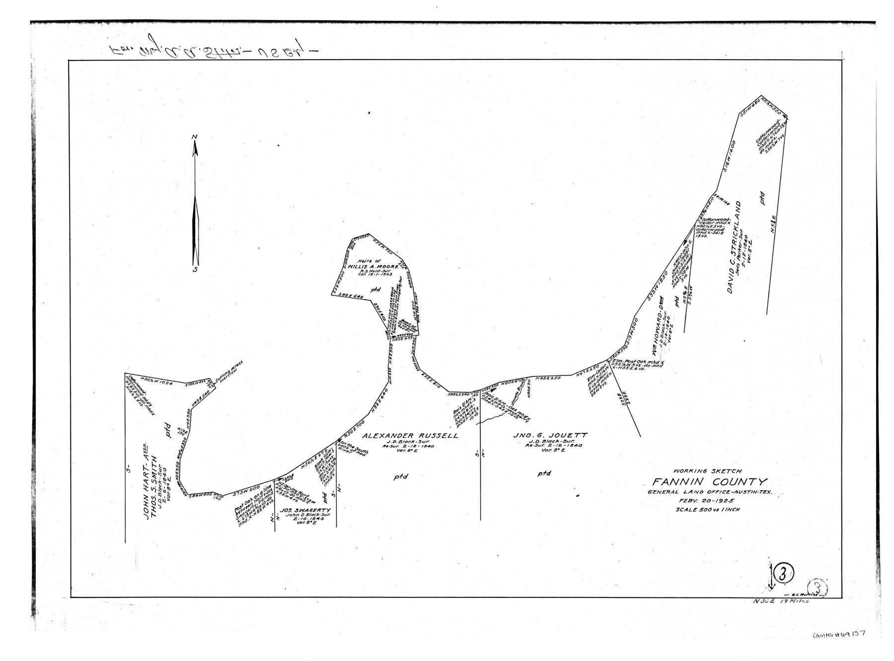
Fannin County Working Sketch 3
-
Map/Doc
69157
-
Collection
General Map Collection
-
Object Dates
2/20/1925 (Creation Date)
-
People and Organizations
G.C. Morriss (Draftsman)
-
Counties
Fannin
-
Subjects
Surveying Working Sketch
-
Height x Width
22.2 x 30.0 inches
56.4 x 76.2 cm
-
Scale
1" = 500 varas
Part of: General Map Collection
Burleson County Sketch File 8

Print $6.00
- Digital $50.00
Burleson County Sketch File 8
Size 8.7 x 5.3 inches
Map/Doc 16654
Bosque County Working Sketch 29

Print $20.00
- Digital $50.00
Bosque County Working Sketch 29
2009
Size 35.9 x 40.6 inches
Map/Doc 88997
Map of Sabine and San Augustine Counties

Print $20.00
- Digital $50.00
Map of Sabine and San Augustine Counties
1863
Size 20.4 x 23.7 inches
Map/Doc 4008
Upton County Working Sketch 37

Print $20.00
- Digital $50.00
Upton County Working Sketch 37
1957
Size 41.1 x 36.9 inches
Map/Doc 69533
Flight Mission No. CGI-4N, Frame 158, Cameron County

Print $20.00
- Digital $50.00
Flight Mission No. CGI-4N, Frame 158, Cameron County
1955
Size 18.5 x 22.2 inches
Map/Doc 84666
Coke County Rolled Sketch 17

Print $20.00
- Digital $50.00
Coke County Rolled Sketch 17
1953
Size 36.1 x 45.2 inches
Map/Doc 8631
Current Miscellaneous File 117

Print $8.00
- Digital $50.00
Current Miscellaneous File 117
2001
Size 11.2 x 8.8 inches
Map/Doc 74823
Nueces County Sketch File 3

Print $40.00
- Digital $50.00
Nueces County Sketch File 3
1847
Size 12.5 x 15.1 inches
Map/Doc 32503
Burnet County Working Sketch 13

Print $40.00
- Digital $50.00
Burnet County Working Sketch 13
1977
Size 40.5 x 49.2 inches
Map/Doc 67856
Hemphill County

Print $20.00
- Digital $50.00
Hemphill County
1888
Size 23.9 x 18.3 inches
Map/Doc 3653
Flight Mission No. DAG-24K, Frame 141, Matagorda County

Print $20.00
- Digital $50.00
Flight Mission No. DAG-24K, Frame 141, Matagorda County
1953
Size 18.5 x 22.4 inches
Map/Doc 86559
You may also like
Colorado County Sketch File 27

Print $20.00
- Digital $50.00
Colorado County Sketch File 27
1911
Size 25.3 x 19.4 inches
Map/Doc 11138
Sutton County Working Sketch 30

Print $20.00
- Digital $50.00
Sutton County Working Sketch 30
1919
Size 42.6 x 16.9 inches
Map/Doc 62373
Hudspeth County Rolled Sketch 37

Print $20.00
- Digital $50.00
Hudspeth County Rolled Sketch 37
1938
Size 23.3 x 29.8 inches
Map/Doc 6250
Live Oak County Sketch File 8

Print $4.00
- Digital $50.00
Live Oak County Sketch File 8
1875
Size 7.6 x 7.9 inches
Map/Doc 30261
Mitchell County Rolled Sketch 2B

Print $20.00
- Digital $50.00
Mitchell County Rolled Sketch 2B
Size 26.9 x 18.6 inches
Map/Doc 6784
East Half - Brown County

Print $40.00
- Digital $50.00
East Half - Brown County
1982
Size 141.3 x 36.8 inches
Map/Doc 97385
Liberty County Sketch File 66

Print $10.00
- Digital $50.00
Liberty County Sketch File 66
1900
Size 10.8 x 7.1 inches
Map/Doc 30130
Howard County Rolled Sketch 5

Print $20.00
- Digital $50.00
Howard County Rolled Sketch 5
Size 19.6 x 16.5 inches
Map/Doc 6234
Lavaca County Working Sketch 7

Print $20.00
- Digital $50.00
Lavaca County Working Sketch 7
1945
Size 23.6 x 26.2 inches
Map/Doc 70360
Hidalgo County Working Sketch 2

Print $20.00
- Digital $50.00
Hidalgo County Working Sketch 2
1906
Size 22.0 x 28.0 inches
Map/Doc 66179
The Republic County of Jasper. Spring 1842

Print $20.00
The Republic County of Jasper. Spring 1842
2020
Size 19.5 x 21.7 inches
Map/Doc 96195
[T. A. Thomson Block T, R. M. Thomson Block 1, and Block B]
![91054, [T. A. Thomson Block T, R. M. Thomson Block 1, and Block B], Twichell Survey Records](https://historictexasmaps.com/wmedia_w700/maps/91054-1.tif.jpg)
Print $20.00
- Digital $50.00
[T. A. Thomson Block T, R. M. Thomson Block 1, and Block B]
Size 17.3 x 20.4 inches
Map/Doc 91054