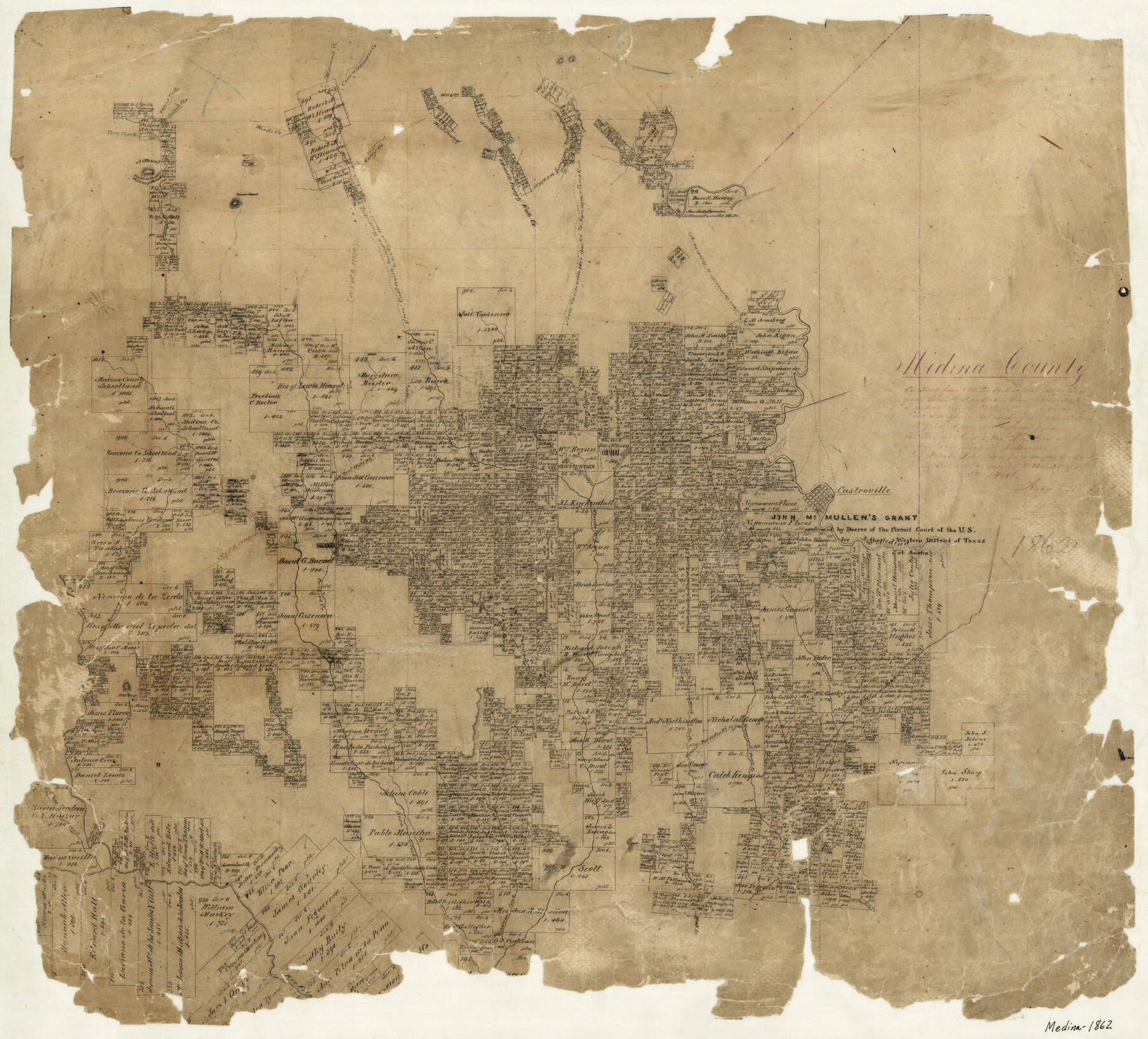
Medina County
-
Map/Doc
3871
-
Collection
General Map Collection
-
Object Dates
8/11/1862 (Creation Date)
-
Counties
Medina
-
Subjects
County
-
Height x Width
23.4 x 26.0 inches
59.4 x 66.0 cm
-
Medium
paper, manuscript
-
Features
[Rio Encinal]
Quihi
Quihi Creek
Castroville
Rio Medina
Pita Road
Chacan Creek
Brae Creek
Black Creek
Live Oak Slough
Parker's Creek
Rancheros Creek
Pilot Knob
Pecan Creek
Deer Creek
Lucky's Creek
Cow Creek
Turkey Creek
Franzisco Perez Creek
Upper Presidio Road
[Road] from Castroville, Quihi and Vanderberg to Upper Hondo
Atascosa Creek
Gasper Flores Creek
Seco Creek
[ ]all's Creek
Tawacano [sic] Creek
Sistendera Creek
Rio Frio
Abandoned Mormon Settlement
[Road] from Castroville over Quihi to Bandera and Camp Verde
Rapid Creek
Cascade Creek
Arroyo Saco [sic]
[High]Mountain
Round Mount
Wards Creek
Arroyo Hondo
Williams Creek
Commissioner's Creek
Rocky Creek
West Prong [of Verde Creek]
Middle Prong of Verde Creek
East Prong [of Verde Creek]
Cypress Creek
Cold Creek
[Road] over Quihi
Castroville Road
Road to Bandera
Road to Camp Verde
Road from Castroville
[Road] from Castroville to Bandera
Old Vandenberg
Gen. Woll's Road
D'Hanis
New Vandenberg
New Fountain
Hondo Creek
Verde Creek
Part of: General Map Collection
Traveller's Map of the State of Texas

Print $20.00
- Digital $50.00
Traveller's Map of the State of Texas
1867
Size 40.7 x 38.7 inches
Map/Doc 2130
Bee County Sketch File Y

Print $4.00
- Digital $50.00
Bee County Sketch File Y
Size 8.8 x 5.4 inches
Map/Doc 14255
Map of Presidio County, Texas

Print $40.00
- Digital $50.00
Map of Presidio County, Texas
Size 42.7 x 82.1 inches
Map/Doc 82050

Bexar County Working Sketch 2

Print $20.00
- Digital $50.00
Bexar County Working Sketch 2
1940
Size 24.8 x 27.9 inches
Map/Doc 67318
Jim Wells County Working Sketch 1

Print $20.00
- Digital $50.00
Jim Wells County Working Sketch 1
Size 17.2 x 22.2 inches
Map/Doc 66599
Flight Mission No. CLL-1N, Frame 191, Willacy County

Print $20.00
- Digital $50.00
Flight Mission No. CLL-1N, Frame 191, Willacy County
1954
Size 18.3 x 22.0 inches
Map/Doc 87061
Map of Hamilton County

Print $20.00
- Digital $50.00
Map of Hamilton County
1863
Size 22.8 x 25.8 inches
Map/Doc 3621
Hutchinson County Rolled Sketch 16

Print $20.00
- Digital $50.00
Hutchinson County Rolled Sketch 16
1912
Size 27.5 x 30.2 inches
Map/Doc 6284
Zavala County Boundary File 1

Print $48.00
- Digital $50.00
Zavala County Boundary File 1
Size 12.8 x 8.3 inches
Map/Doc 60233
Jeff Davis County Sketch File 11

Print $20.00
- Digital $50.00
Jeff Davis County Sketch File 11
Size 17.7 x 29.9 inches
Map/Doc 11858
Knox County Working Sketch 18

Print $20.00
- Digital $50.00
Knox County Working Sketch 18
1988
Size 40.0 x 29.7 inches
Map/Doc 70260
You may also like
Polk County Rolled Sketch 34

Print $20.00
- Digital $50.00
Polk County Rolled Sketch 34
2023
Size 23.9 x 36.2 inches
Map/Doc 97193
Freestone County Working Sketch 21

Print $40.00
- Digital $50.00
Freestone County Working Sketch 21
1980
Size 49.0 x 42.3 inches
Map/Doc 69263
Somervell County Rolled Sketch D

Print $20.00
- Digital $50.00
Somervell County Rolled Sketch D
1939
Size 17.3 x 21.0 inches
Map/Doc 7794
Lampasas County Sketch File 19

Print $4.00
- Digital $50.00
Lampasas County Sketch File 19
1888
Size 10.3 x 8.2 inches
Map/Doc 29432
[State Line from Southeast New Mexico to Yoakum County]
![92013, [State Line from Southeast New Mexico to Yoakum County], Twichell Survey Records](https://historictexasmaps.com/wmedia_w700/maps/92013-1.tif.jpg)
Print $20.00
- Digital $50.00
[State Line from Southeast New Mexico to Yoakum County]
Size 32.3 x 11.7 inches
Map/Doc 92013
Comanche County Sketch File 23

Print $4.00
- Digital $50.00
Comanche County Sketch File 23
Size 8.3 x 7.5 inches
Map/Doc 19111
Hood County Working Sketch 24

Print $20.00
- Digital $50.00
Hood County Working Sketch 24
1993
Size 36.2 x 37.4 inches
Map/Doc 66218
Gonzales County Working Sketch 3

Print $20.00
- Digital $50.00
Gonzales County Working Sketch 3
1943
Size 37.8 x 41.5 inches
Map/Doc 63218
Throckmorton County Rolled Sketch 3

Print $20.00
- Digital $50.00
Throckmorton County Rolled Sketch 3
1987
Size 31.2 x 36.3 inches
Map/Doc 7986
![91861, [Block D7], Twichell Survey Records](https://historictexasmaps.com/wmedia_w700/maps/91861-1.tif.jpg)
Orange County Rolled Sketch 30

Print $20.00
- Digital $50.00
Orange County Rolled Sketch 30
1960
Size 32.4 x 34.9 inches
Map/Doc 9650
Texas Intracoastal Waterway - Laguna Madre - Dagger Hill to Potrero Grande

Print $20.00
- Digital $50.00
Texas Intracoastal Waterway - Laguna Madre - Dagger Hill to Potrero Grande
1960
Size 38.7 x 27.2 inches
Map/Doc 73510