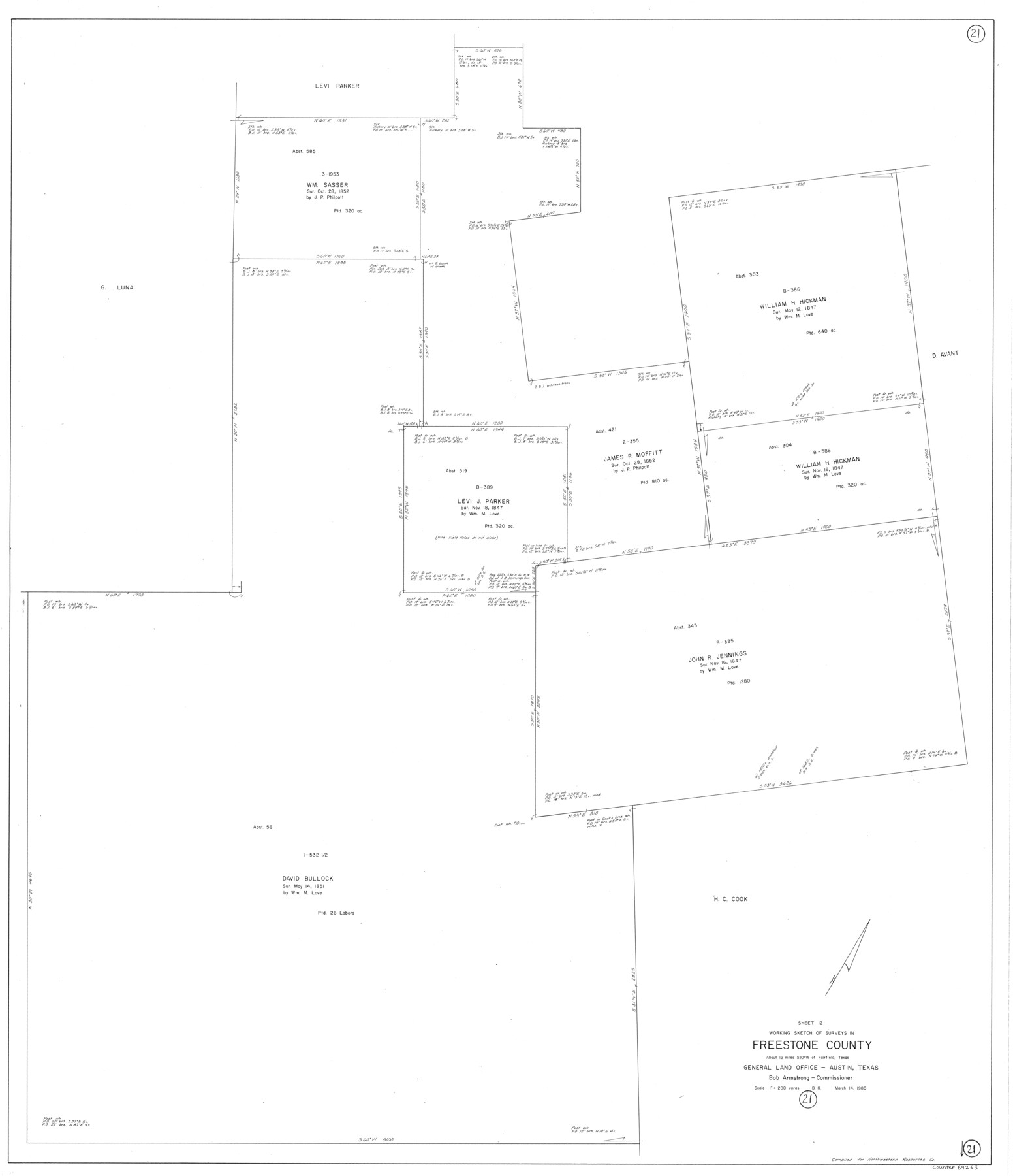
Freestone County Working Sketch 21
-
Map/Doc
69263
-
Collection
General Map Collection
-
Object Dates
3/14/1980 (Creation Date)
-
People and Organizations
Beverly Robison (Draftsman)
-
Counties
Freestone
-
Subjects
Surveying Working Sketch
-
Height x Width
49.0 x 42.3 inches
124.5 x 107.4 cm
-
Scale
1" = 200 varas
Part of: General Map Collection
Donley County Boundary File 1

Print $12.00
- Digital $50.00
Donley County Boundary File 1
Size 11.1 x 8.6 inches
Map/Doc 52613
Baylor County Sketch File 14

Print $4.00
- Digital $50.00
Baylor County Sketch File 14
1879
Size 13.0 x 8.2 inches
Map/Doc 14181
Menard County Working Sketch 31

Print $20.00
- Digital $50.00
Menard County Working Sketch 31
1980
Size 25.6 x 24.5 inches
Map/Doc 70978
Jefferson County Sketch File 32

Print $4.00
- Digital $50.00
Jefferson County Sketch File 32
1900
Size 11.3 x 8.7 inches
Map/Doc 28195
Nueces County Aerial Photograph Index Sheet 1

Print $20.00
- Digital $50.00
Nueces County Aerial Photograph Index Sheet 1
1956
Size 23.4 x 19.6 inches
Map/Doc 83736
Eastland County Working Sketch 53

Print $20.00
- Digital $50.00
Eastland County Working Sketch 53
1982
Size 22.9 x 27.4 inches
Map/Doc 68834
Red River County Sketch File A

Print $40.00
- Digital $50.00
Red River County Sketch File A
1900
Size 20.1 x 23.8 inches
Map/Doc 12236
Flight Mission No. DCL-5C, Frame 72, Kenedy County

Print $20.00
- Digital $50.00
Flight Mission No. DCL-5C, Frame 72, Kenedy County
1943
Size 18.7 x 22.5 inches
Map/Doc 85855
Harris County Historic Topographic 23

Print $20.00
- Digital $50.00
Harris County Historic Topographic 23
1916
Size 29.2 x 22.6 inches
Map/Doc 65834
Callahan County Working Sketch 10

Print $20.00
- Digital $50.00
Callahan County Working Sketch 10
1967
Size 26.9 x 25.5 inches
Map/Doc 67892
Andrews County Rolled Sketch 33

Print $40.00
- Digital $50.00
Andrews County Rolled Sketch 33
Size 131.2 x 22.0 inches
Map/Doc 9003
Intracoastal Waterway in Texas - Corpus Christi to Point Isabel including Arroyo Colorado to Mo. Pac. R.R. Bridge Near Harlingen

Print $20.00
- Digital $50.00
Intracoastal Waterway in Texas - Corpus Christi to Point Isabel including Arroyo Colorado to Mo. Pac. R.R. Bridge Near Harlingen
1934
Size 21.5 x 32.4 inches
Map/Doc 61883
You may also like
Crockett County Working Sketch 45

Print $20.00
- Digital $50.00
Crockett County Working Sketch 45
1933
Size 33.7 x 26.8 inches
Map/Doc 68378
[Gulf, Colorado & Santa Fe Railway line through Fort Bend Co.]
![64212, [Gulf, Colorado & Santa Fe Railway line through Fort Bend Co.], General Map Collection](https://historictexasmaps.com/wmedia_w700/maps/64212.tif.jpg)
Print $20.00
- Digital $50.00
[Gulf, Colorado & Santa Fe Railway line through Fort Bend Co.]
1898
Size 14.2 x 33.5 inches
Map/Doc 64212
[I. & G. N. RR. Co. Blk. 6, Blks M8, M9 and M10]
![90267, [I. & G. N. RR. Co. Blk. 6, Blks M8, M9 and M10], Twichell Survey Records](https://historictexasmaps.com/wmedia_w700/maps/90267-1.tif.jpg)
Print $20.00
- Digital $50.00
[I. & G. N. RR. Co. Blk. 6, Blks M8, M9 and M10]
Size 34.2 x 20.3 inches
Map/Doc 90267
Young County Working Sketch 20

Print $20.00
- Digital $50.00
Young County Working Sketch 20
1961
Size 25.5 x 23.2 inches
Map/Doc 62043
Lavaca County Sketch File 4

Print $6.00
- Digital $50.00
Lavaca County Sketch File 4
Size 8.2 x 15.3 inches
Map/Doc 29636
Flight Mission No. DCL-7C, Frame 95, Kenedy County

Print $20.00
- Digital $50.00
Flight Mission No. DCL-7C, Frame 95, Kenedy County
1943
Size 15.4 x 15.2 inches
Map/Doc 86067
Map of Nacogdoches County

Print $20.00
- Digital $50.00
Map of Nacogdoches County
1881
Size 24.1 x 21.5 inches
Map/Doc 4605
Hardin County Sketch File 31

Print $2.00
- Digital $50.00
Hardin County Sketch File 31
Size 8.5 x 7.1 inches
Map/Doc 25162
Hudspeth County Sketch File 49

Print $18.00
- Digital $50.00
Hudspeth County Sketch File 49
1986
Size 11.2 x 8.7 inches
Map/Doc 27065
Flight Mission No. CRC-3R, Frame 24, Chambers County

Print $20.00
- Digital $50.00
Flight Mission No. CRC-3R, Frame 24, Chambers County
1956
Size 18.6 x 22.2 inches
Map/Doc 84798
Baylor County, Texas

Print $20.00
- Digital $50.00
Baylor County, Texas
Size 21.7 x 18.9 inches
Map/Doc 525
Crosby County Boundary File 4

Print $88.00
- Digital $50.00
Crosby County Boundary File 4
Size 14.8 x 9.1 inches
Map/Doc 52003