Jefferson County Sketch File 32
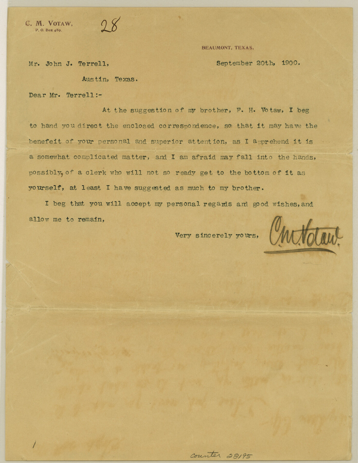
[Letter from C. M. Votaw to John J. Terrell]
-
Map/Doc
28195
-
Collection
General Map Collection
-
Object Dates
9/20/1900 (Creation Date)
9/20/1900 (Correspondence Date)
-
People and Organizations
C.M. Votaw (Surveyor/Engineer)
-
Counties
Jefferson
-
Subjects
Surveying Sketch File
-
Height x Width
11.3 x 8.7 inches
28.7 x 22.1 cm
-
Medium
paper, print
Part of: General Map Collection
Right-of-Way and Track Map, Texas State Railroad operated by the T. and N. O. R.R. Co.

Print $40.00
- Digital $50.00
Right-of-Way and Track Map, Texas State Railroad operated by the T. and N. O. R.R. Co.
1917
Size 24.4 x 55.8 inches
Map/Doc 64174
Brooks County Working Sketch 16

Print $20.00
- Digital $50.00
Brooks County Working Sketch 16
1972
Size 35.0 x 29.7 inches
Map/Doc 67800
Map of Part of Texas Prison System, Blue Ridge State Farm near Camp No. 1 Showing Buildings and Property Lines

Print $20.00
- Digital $50.00
Map of Part of Texas Prison System, Blue Ridge State Farm near Camp No. 1 Showing Buildings and Property Lines
Size 20.3 x 25.4 inches
Map/Doc 62980
Chambers County Sketch File 1

Print $4.00
- Digital $50.00
Chambers County Sketch File 1
1856
Size 7.8 x 12.2 inches
Map/Doc 17516
Presidio County Working Sketch 61

Print $20.00
- Digital $50.00
Presidio County Working Sketch 61
1957
Size 40.0 x 35.0 inches
Map/Doc 71738
Tom Green County Sketch File 14

Print $20.00
- Digital $50.00
Tom Green County Sketch File 14
Size 34.8 x 45.7 inches
Map/Doc 10401
Denton County Sketch File 18

Print $4.00
- Digital $50.00
Denton County Sketch File 18
1856
Size 7.9 x 7.3 inches
Map/Doc 20731
Culberson Co.

Print $40.00
- Digital $50.00
Culberson Co.
1908
Size 49.0 x 32.9 inches
Map/Doc 66796
Duval County Rolled Sketch 21

Print $20.00
- Digital $50.00
Duval County Rolled Sketch 21
Size 33.2 x 42.2 inches
Map/Doc 8812
Borden County Rolled Sketch 3

Print $20.00
- Digital $50.00
Borden County Rolled Sketch 3
1908
Size 29.0 x 33.6 inches
Map/Doc 5155
Map of Rains County

Print $20.00
- Digital $50.00
Map of Rains County
1873
Size 12.0 x 12.4 inches
Map/Doc 4619
[Sketch for Mineral Application 26501 - Sabine River, T. A. Oldhausen]
![2840, [Sketch for Mineral Application 26501 - Sabine River, T. A. Oldhausen], General Map Collection](https://historictexasmaps.com/wmedia_w700/maps/2840.tif.jpg)
Print $20.00
- Digital $50.00
[Sketch for Mineral Application 26501 - Sabine River, T. A. Oldhausen]
1931
Size 24.3 x 35.5 inches
Map/Doc 2840
You may also like
Treaty to Resolve Pending Boundary Differences and Maintain the Rio Grande and Colorado River as the International Boundary Between the United States of American and Mexico

Print $20.00
- Digital $50.00
Treaty to Resolve Pending Boundary Differences and Maintain the Rio Grande and Colorado River as the International Boundary Between the United States of American and Mexico
1970
Size 10.9 x 35.6 inches
Map/Doc 83104
Hamilton County

Print $20.00
- Digital $50.00
Hamilton County
1898
Size 35.3 x 42.5 inches
Map/Doc 66849
Triangulation Net of the United States

Print $20.00
- Digital $50.00
Triangulation Net of the United States
1938
Size 28.1 x 42.2 inches
Map/Doc 3117
Hill County Working Sketch 2

Print $20.00
- Digital $50.00
Hill County Working Sketch 2
1947
Size 24.2 x 26.7 inches
Map/Doc 66188
Harris County Working Sketch 44

Print $20.00
- Digital $50.00
Harris County Working Sketch 44
1941
Size 24.9 x 38.3 inches
Map/Doc 65936
Kendall County Sketch File 11

Print $8.00
- Digital $50.00
Kendall County Sketch File 11
1924
Size 11.2 x 8.7 inches
Map/Doc 28695
General Highway Map, Sherman County, Texas

Print $20.00
General Highway Map, Sherman County, Texas
1940
Size 18.2 x 24.9 inches
Map/Doc 79243
Bowie County Rolled Sketch 5

Print $20.00
- Digital $50.00
Bowie County Rolled Sketch 5
Size 33.1 x 44.5 inches
Map/Doc 8457
General Highway Map, Webb County, Texas

Print $20.00
General Highway Map, Webb County, Texas
1940
Size 18.2 x 24.9 inches
Map/Doc 79273
Hill County Working Sketch 3

Print $20.00
- Digital $50.00
Hill County Working Sketch 3
1948
Size 22.7 x 19.5 inches
Map/Doc 66189
Map Showing Eastern Portion of Pecos County, Texas

Print $40.00
- Digital $50.00
Map Showing Eastern Portion of Pecos County, Texas
Size 62.2 x 43.5 inches
Map/Doc 89835
[Capitol League Sketch E, Hockley County]
![1765, [Capitol League Sketch E, Hockley County], General Map Collection](https://historictexasmaps.com/wmedia_w700/maps/1765.tif.jpg)
Print $20.00
- Digital $50.00
[Capitol League Sketch E, Hockley County]
1910
Size 15.8 x 19.9 inches
Map/Doc 1765