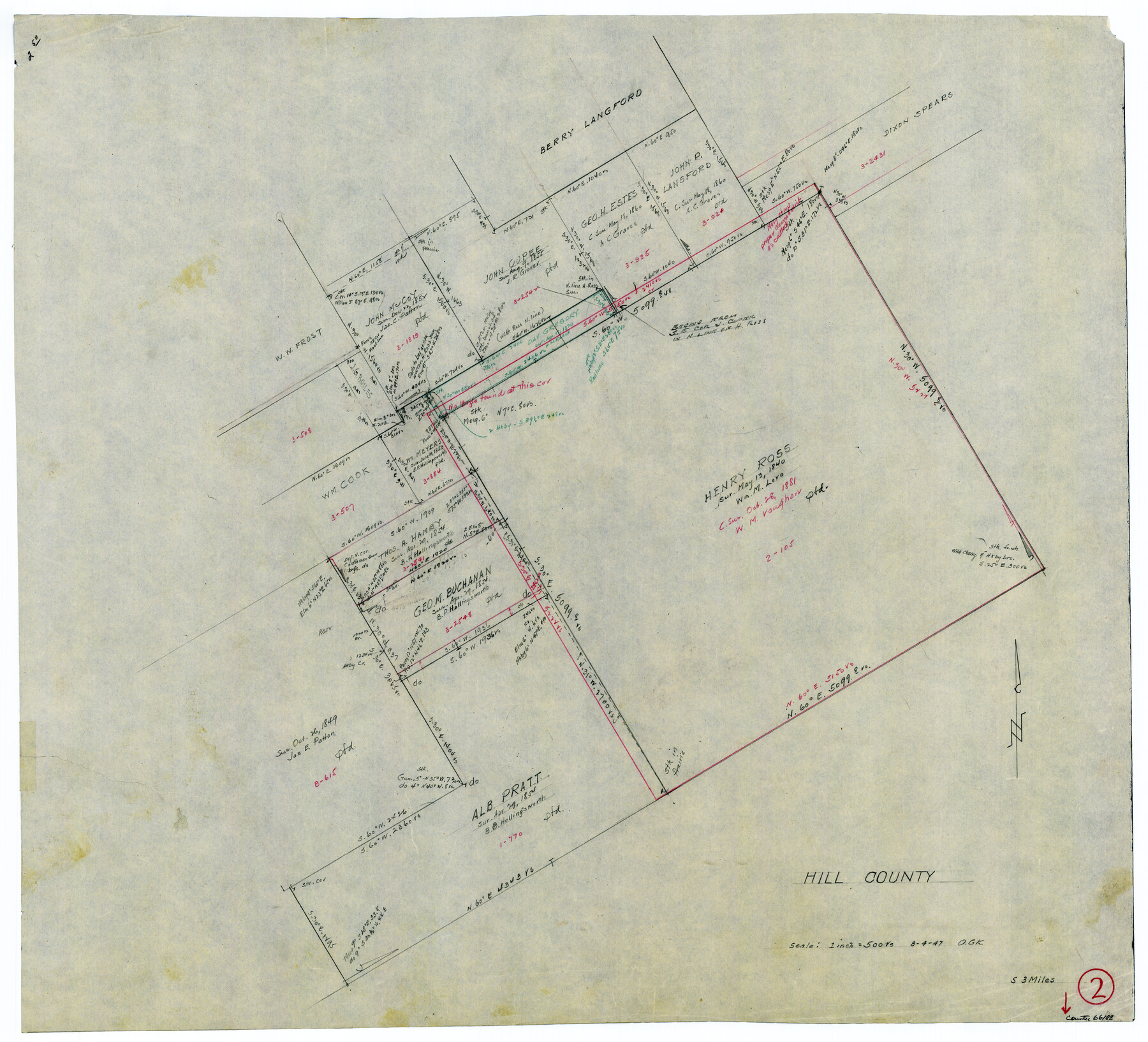
Hill County Working Sketch 2
-
Map/Doc
66188
-
Collection
General Map Collection
-
Object Dates
8/4/1947 (Creation Date)
-
People and Organizations
Otto G. Kurio (Draftsman)
-
Counties
Hill
-
Subjects
Surveying Working Sketch
-
Height x Width
24.2 x 26.7 inches
61.5 x 67.8 cm
-
Scale
1" = 500 varas
Part of: General Map Collection
Map of DeWitt County

Print $20.00
- Digital $50.00
Map of DeWitt County
1853
Size 21.5 x 25.5 inches
Map/Doc 3479

Victoria County

Print $20.00
- Digital $50.00
Victoria County
1858
Size 26.5 x 29.2 inches
Map/Doc 4115
Boundary between Republic of Texas and US from Logan's Ferry to Red River - surveyed in 1841

Print $20.00
- Digital $50.00
Boundary between Republic of Texas and US from Logan's Ferry to Red River - surveyed in 1841
1841
Size 19.4 x 27.4 inches
Map/Doc 65415
Kenedy County Sketch File 3

Print $22.00
- Digital $50.00
Kenedy County Sketch File 3
2003
Size 11.0 x 8.5 inches
Map/Doc 82452

Henderson County

Print $20.00
- Digital $50.00
Henderson County
1856
Size 17.9 x 29.2 inches
Map/Doc 3664
Jim Hogg County Sketch File 6

Print $20.00
- Digital $50.00
Jim Hogg County Sketch File 6
1939
Size 17.9 x 19.6 inches
Map/Doc 11886
Wichita County Working Sketch 22

Print $20.00
- Digital $50.00
Wichita County Working Sketch 22
1952
Size 22.2 x 27.1 inches
Map/Doc 72532
San Luis Pass to East Matagorda Bay

Print $20.00
- Digital $50.00
San Luis Pass to East Matagorda Bay
1964
Size 34.7 x 46.6 inches
Map/Doc 69964
Part of Laguna Madre in Willacy and Cameron Counties, showing Subdivision for Mineral Development

Print $20.00
- Digital $50.00
Part of Laguna Madre in Willacy and Cameron Counties, showing Subdivision for Mineral Development
1950
Size 45.1 x 36.8 inches
Map/Doc 1925
Runnels County Sketch File 31

Print $6.00
Runnels County Sketch File 31
1950
Size 11.5 x 8.8 inches
Map/Doc 35496
You may also like
Sutton County Working Sketch 11

Print $40.00
- Digital $50.00
Sutton County Working Sketch 11
1972
Size 76.8 x 45.5 inches
Map/Doc 62354
Travis County Sketch File 5

Print $4.00
- Digital $50.00
Travis County Sketch File 5
Size 11.0 x 8.2 inches
Map/Doc 38281

Eastland County Working Sketch 35

Print $20.00
- Digital $50.00
Eastland County Working Sketch 35
1962
Size 24.0 x 21.6 inches
Map/Doc 68816
Flight Mission No. DQN-1K, Frame 41, Calhoun County

Print $20.00
- Digital $50.00
Flight Mission No. DQN-1K, Frame 41, Calhoun County
1953
Size 18.5 x 22.2 inches
Map/Doc 84141
Nueces County Sketch File 63

Print $4.00
- Digital $50.00
Nueces County Sketch File 63
1978
Size 14.2 x 8.5 inches
Map/Doc 32973
Pecos County Working Sketch Graphic Index - south part

Print $20.00
- Digital $50.00
Pecos County Working Sketch Graphic Index - south part
1976
Size 35.3 x 43.2 inches
Map/Doc 76665
[Block B9 in Southwest Corner of Crosby County]
![90496, [Block B9 in Southwest Corner of Crosby County], Twichell Survey Records](https://historictexasmaps.com/wmedia_w700/maps/90496-1.tif.jpg)
Print $20.00
- Digital $50.00
[Block B9 in Southwest Corner of Crosby County]
Size 26.1 x 9.9 inches
Map/Doc 90496

Orange County Boundary File 9

Print $16.00
- Digital $50.00
Orange County Boundary File 9
Size 11.2 x 8.7 inches
Map/Doc 57782
Eastland County Working Sketch 39

Print $20.00
- Digital $50.00
Eastland County Working Sketch 39
1969
Size 43.0 x 37.4 inches
Map/Doc 68820
Sabine Pass and Lake

Print $20.00
- Digital $50.00
Sabine Pass and Lake
1958
Size 47.1 x 27.5 inches
Map/Doc 69823