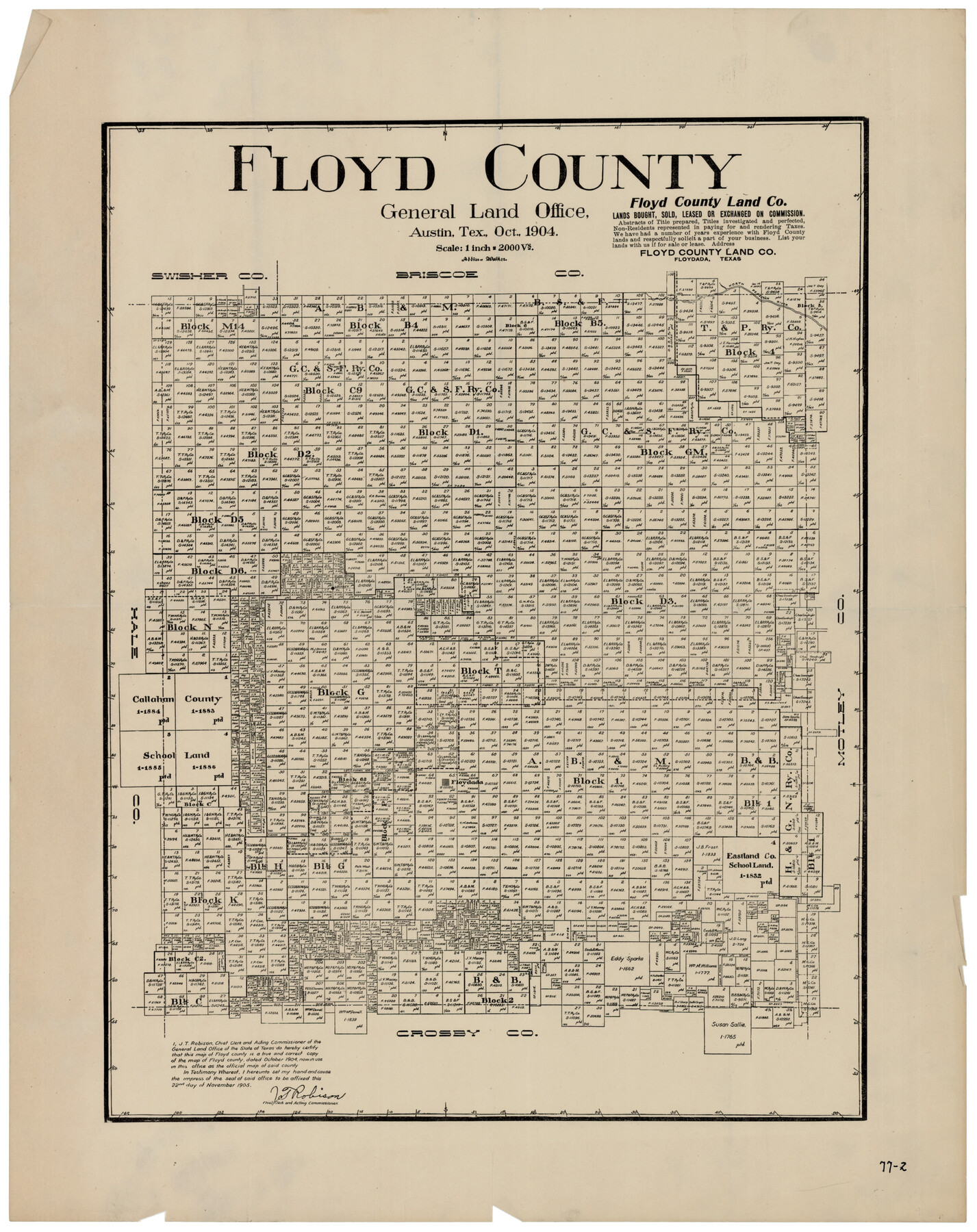
Floyd County
77-2
-
Map/Doc
90842
-
Collection
Twichell Survey Records
-
Object Dates
10/1904 (Creation Date)
-
People and Organizations
General Land Office (Publisher)
-
Counties
Floyd
-
Subjects
County
-
Height x Width
19.9 x 25.2 inches
50.6 x 64.0 cm
Part of: Twichell Survey Records
[Block C-41, Sections 32, 35, 35 1/2, and vicinity]
![92570, [Block C-41, Sections 32, 35, 35 1/2, and vicinity], Twichell Survey Records](https://historictexasmaps.com/wmedia_w700/maps/92570-1.tif.jpg)
Print $20.00
- Digital $50.00
[Block C-41, Sections 32, 35, 35 1/2, and vicinity]
Size 23.9 x 19.4 inches
Map/Doc 92570
[Area north of Leagues 1 & 4, Morris County School Land]
![90353, [Area north of Leagues 1 & 4, Morris County School Land], Twichell Survey Records](https://historictexasmaps.com/wmedia_w700/maps/90353-1.tif.jpg)
Print $20.00
- Digital $50.00
[Area north of Leagues 1 & 4, Morris County School Land]
Size 21.3 x 16.0 inches
Map/Doc 90353
Sketch from Dawson, Martin and Gaines Co's. (a part of Andrews Co. added)

Print $40.00
- Digital $50.00
Sketch from Dawson, Martin and Gaines Co's. (a part of Andrews Co. added)
1900
Size 45.0 x 50.6 inches
Map/Doc 89781
[Blocks B, T, and 1]
![90972, [Blocks B, T, and 1], Twichell Survey Records](https://historictexasmaps.com/wmedia_w700/maps/90972-1.tif.jpg)
Print $2.00
- Digital $50.00
[Blocks B, T, and 1]
Size 9.2 x 13.7 inches
Map/Doc 90972
[PSL Block 1 along State line]
![90579, [PSL Block 1 along State line], Twichell Survey Records](https://historictexasmaps.com/wmedia_w700/maps/90579-1.tif.jpg)
Print $2.00
- Digital $50.00
[PSL Block 1 along State line]
Size 14.1 x 8.0 inches
Map/Doc 90579
Sketch Showing Boundary Between Randall and Deaf Smith Counties

Print $20.00
- Digital $50.00
Sketch Showing Boundary Between Randall and Deaf Smith Counties
Size 13.4 x 33.3 inches
Map/Doc 91832
[Area around Lee County School Land Leagues]
![90804, [Area around Lee County School Land Leagues], Twichell Survey Records](https://historictexasmaps.com/wmedia_w700/maps/90804-1.tif.jpg)
Print $3.00
- Digital $50.00
[Area around Lee County School Land Leagues]
Size 9.7 x 15.2 inches
Map/Doc 90804
[Floyd County School Land Lgs. 180-183, Fisher County School Land Lgs. 105-108, and part of Blk. V]
![90191, [Floyd County Schoo Land Lgs. 180-183, Fisher County School Land Lgs. 105-108, and part of Blk. V], Twichell Survey Records](https://historictexasmaps.com/wmedia_w700/maps/90191-1.tif.jpg)
Print $2.00
- Digital $50.00
[Floyd County School Land Lgs. 180-183, Fisher County School Land Lgs. 105-108, and part of Blk. V]
Size 8.8 x 10.3 inches
Map/Doc 90191
[T. & P. Block 35, Townships 4N and 5N]
![90574, [T. & P. Block 35, Townships 4N and 5N], Twichell Survey Records](https://historictexasmaps.com/wmedia_w700/maps/90574-1.tif.jpg)
Print $20.00
- Digital $50.00
[T. & P. Block 35, Townships 4N and 5N]
1907
Size 29.8 x 34.7 inches
Map/Doc 90574
[I. & G. N. RR. Co. Block I]
![89828, [I. &G. N. RR. Co. Block I], Twichell Survey Records](https://historictexasmaps.com/wmedia_w700/maps/89828-1.tif.jpg)
Print $20.00
- Digital $50.00
[I. & G. N. RR. Co. Block I]
Size 43.0 x 31.7 inches
Map/Doc 89828
Sylvan Sanders Survey Section 20, Block A

Print $20.00
- Digital $50.00
Sylvan Sanders Survey Section 20, Block A
1952
Size 37.0 x 25.1 inches
Map/Doc 92722
Capitol Lands Surveyed by J. T. Munson

Print $20.00
- Digital $50.00
Capitol Lands Surveyed by J. T. Munson
Size 25.8 x 19.4 inches
Map/Doc 90597
You may also like
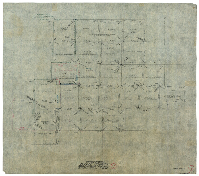
Duval County Working Sketch 9
Print $20.00
- Digital $50.00
Duval County Working Sketch 9
1935
Size 25.8 x 29.1 inches
Map/Doc 68722

Roberts County Working Sketch 22

Print $20.00
- Digital $50.00
Roberts County Working Sketch 22
1978
Size 31.0 x 42.9 inches
Map/Doc 63548
Duval County Boundary File 1a

Print $18.00
- Digital $50.00
Duval County Boundary File 1a
Size 12.8 x 8.4 inches
Map/Doc 52670
Eastland County

Print $20.00
- Digital $50.00
Eastland County
1945
Size 42.8 x 42.5 inches
Map/Doc 73136
Gray County Sketch File 10

Print $14.00
- Digital $50.00
Gray County Sketch File 10
Size 9.7 x 6.3 inches
Map/Doc 24445
Flight Mission No. BQR-14K, Frame 37, Brazoria County

Print $20.00
- Digital $50.00
Flight Mission No. BQR-14K, Frame 37, Brazoria County
1952
Size 18.6 x 22.2 inches
Map/Doc 84094
Roberts County Rolled Sketch 3

Print $40.00
- Digital $50.00
Roberts County Rolled Sketch 3
Size 37.7 x 48.9 inches
Map/Doc 8359
Shelby County Rolled Sketch 15

Print $40.00
- Digital $50.00
Shelby County Rolled Sketch 15
1948
Size 22.5 x 53.9 inches
Map/Doc 9924
Morris County Rolled Sketch 2A

Print $20.00
- Digital $50.00
Morris County Rolled Sketch 2A
Size 24.4 x 19.3 inches
Map/Doc 10262
Kaufman County Sketch File 20

Print $20.00
- Digital $50.00
Kaufman County Sketch File 20
1950
Size 23.2 x 34.8 inches
Map/Doc 11908
Flight Mission No. DAG-26K, Frame 63, Matagorda County

Print $20.00
- Digital $50.00
Flight Mission No. DAG-26K, Frame 63, Matagorda County
1953
Size 18.5 x 22.2 inches
Map/Doc 86583