Morris County Rolled Sketch 2A
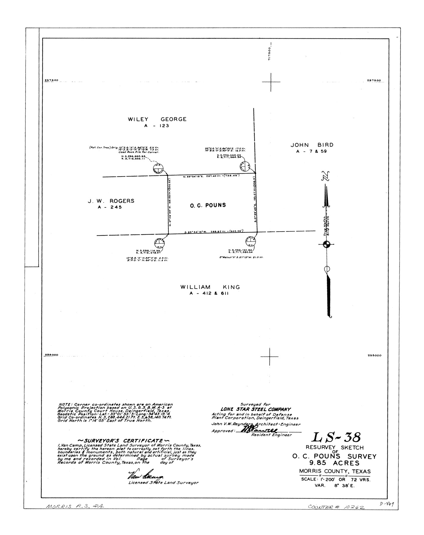
LS-38 - Resurvey sketch of O.C. Pouns survey, 9.85 acres, Morris County, Texas
-
Map/Doc
10262
-
Collection
General Map Collection
-
People and Organizations
Van Camp (Surveyor/Engineer)
-
Counties
Morris
-
Subjects
Surveying Rolled Sketch
-
Height x Width
24.4 x 19.3 inches
62.0 x 49.0 cm
-
Medium
linen, manuscript
-
Scale
1" = 72 varas
-
Comments
See Morris County Rolled Sketch 2 (9550) for map of all retracement surveys made for Lone Star Steel Company.
Related maps
Morris County Rolled Sketch 2

Print $40.00
- Digital $50.00
Morris County Rolled Sketch 2
1944
Size 59.4 x 43.5 inches
Map/Doc 9550
Part of: General Map Collection
Duval County Sketch File 19b

Print $6.00
- Digital $50.00
Duval County Sketch File 19b
Size 15.4 x 9.7 inches
Map/Doc 21320
Johnson County Rolled Sketch B

Print $20.00
- Digital $50.00
Johnson County Rolled Sketch B
1891
Size 28.2 x 38.9 inches
Map/Doc 6449
Ochiltree County Sketch File 6

Print $20.00
- Digital $50.00
Ochiltree County Sketch File 6
1930
Size 9.5 x 32.7 inches
Map/Doc 42203
Red River County Sketch File 17b

Print $4.00
- Digital $50.00
Red River County Sketch File 17b
1875
Size 12.9 x 8.1 inches
Map/Doc 35147
Menard County Sketch File 10

Print $20.00
- Digital $50.00
Menard County Sketch File 10
1885
Size 32.5 x 18.0 inches
Map/Doc 12074
[Surveys in the Victoria District along the Guadalupe and Coleto Rivers]
![21, [Surveys in the Victoria District along the Guadalupe and Coleto Rivers], General Map Collection](https://historictexasmaps.com/wmedia_w700/maps/21.tif.jpg)
Print $20.00
- Digital $50.00
[Surveys in the Victoria District along the Guadalupe and Coleto Rivers]
1840
Size 26.0 x 19.6 inches
Map/Doc 21
Chambers County Sketch File 50

Print $49.00
- Digital $50.00
Chambers County Sketch File 50
1917
Size 14.4 x 8.8 inches
Map/Doc 18048
Caldwell County Sketch File 3

Print $4.00
- Digital $50.00
Caldwell County Sketch File 3
1872
Size 12.7 x 8.1 inches
Map/Doc 35827
La Salle County Sketch File 13a

Print $8.00
- Digital $50.00
La Salle County Sketch File 13a
1878
Size 12.7 x 8.0 inches
Map/Doc 29479
Texas Panhandle East Boundary Line

Print $40.00
- Digital $50.00
Texas Panhandle East Boundary Line
Size 66.1 x 9.3 inches
Map/Doc 65380
Ochiltree County Boundary File 5c

Print $30.00
- Digital $50.00
Ochiltree County Boundary File 5c
Size 11.2 x 8.7 inches
Map/Doc 57699
Rockwall County Sketch File 5

Print $6.00
Rockwall County Sketch File 5
1861
Size 13.0 x 8.3 inches
Map/Doc 35422
You may also like
Val Verde County Sketch File 44A

Print $10.00
- Digital $50.00
Val Verde County Sketch File 44A
1940
Size 14.5 x 8.8 inches
Map/Doc 39311
Irion County Rolled Sketch 14

Print $20.00
- Digital $50.00
Irion County Rolled Sketch 14
1946
Size 25.3 x 21.9 inches
Map/Doc 6324
Jasper County Sketch File 30

Print $20.00
- Digital $50.00
Jasper County Sketch File 30
1948
Size 11.3 x 8.8 inches
Map/Doc 27858
San Saba County

Print $20.00
- Digital $50.00
San Saba County
1987
Size 46.3 x 42.5 inches
Map/Doc 73284
Coast Chart No. 212 - From Latitude 26° 33' to the Rio Grande, Texas

Print $20.00
- Digital $50.00
Coast Chart No. 212 - From Latitude 26° 33' to the Rio Grande, Texas
1886
Size 21.9 x 17.5 inches
Map/Doc 73505
Aerial View of San Antonio de Béxar and Alamo Fortifications

Aerial View of San Antonio de Béxar and Alamo Fortifications
2026
Size 11.0 x 17.0 inches
Map/Doc 97522
Haskell County

Print $20.00
- Digital $50.00
Haskell County
1873
Size 20.1 x 24.2 inches
Map/Doc 3642
United States - Gulf Coast Texas - Southern part of Laguna Madre

Print $20.00
- Digital $50.00
United States - Gulf Coast Texas - Southern part of Laguna Madre
1941
Size 26.4 x 18.2 inches
Map/Doc 72945
Gonzales County

Print $20.00
- Digital $50.00
Gonzales County
1880
Size 26.3 x 24.0 inches
Map/Doc 4550
Hamilton County Working Sketch 18

Print $20.00
- Digital $50.00
Hamilton County Working Sketch 18
1952
Size 22.4 x 25.1 inches
Map/Doc 63356
Crane County Working Sketch 28

Print $40.00
- Digital $50.00
Crane County Working Sketch 28
1972
Size 49.4 x 49.1 inches
Map/Doc 68305
Hemphill County Working Sketch 34

Print $40.00
- Digital $50.00
Hemphill County Working Sketch 34
1976
Size 33.9 x 64.2 inches
Map/Doc 66129