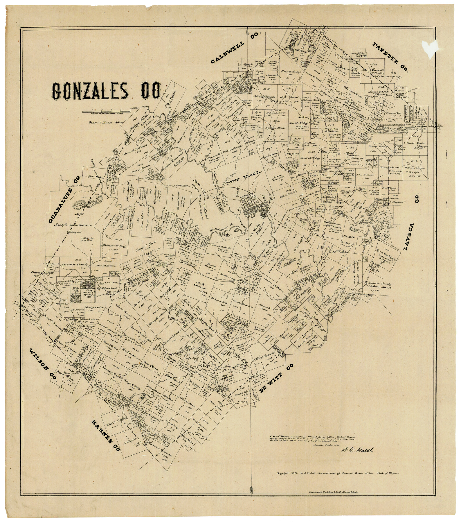
Gonzales County
Gonzales County Sketch File 8
-
Map/Doc
4550
-
Collection
General Map Collection
-
Object Dates
1880 (Creation Date)
-
People and Organizations
W.C. Walsh (GLO Commissioner)
August Gast & Co. (Lithographer)
-
Counties
Gonzales
-
Subjects
County
-
Height x Width
26.3 x 24.0 inches
66.8 x 61.0 cm
-
Scale
1" = 4000 varas
-
Comments
Copyright 1880.
"Llithographed by A. Gast & Co's new process St. Louis."
Center of county marked.
Part of: General Map Collection
Henderson County Rolled Sketch 11

Print $20.00
- Digital $50.00
Henderson County Rolled Sketch 11
1915
Size 29.0 x 42.6 inches
Map/Doc 76151
Shackelford County Working Sketch 8

Print $20.00
- Digital $50.00
Shackelford County Working Sketch 8
1973
Size 31.9 x 28.7 inches
Map/Doc 63848
Coleman County Sketch File 10

Print $20.00
- Digital $50.00
Coleman County Sketch File 10
1848
Size 28.0 x 13.2 inches
Map/Doc 11119
Glasscock County

Print $20.00
- Digital $50.00
Glasscock County
1933
Size 41.1 x 34.7 inches
Map/Doc 77290
Borden County Working Sketch 4

Print $20.00
- Digital $50.00
Borden County Working Sketch 4
1944
Size 21.7 x 23.7 inches
Map/Doc 67464
Upshur County Working Sketch 6

Print $20.00
- Digital $50.00
Upshur County Working Sketch 6
1943
Size 28.6 x 34.3 inches
Map/Doc 69562
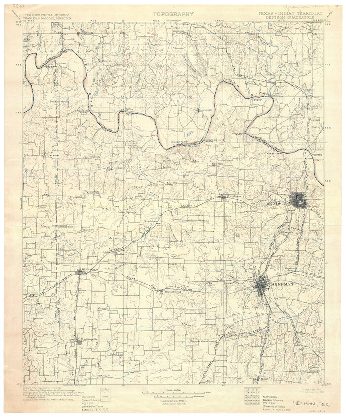
Texas-Indian Territory Denison Quadrangle
Print $20.00
- Digital $50.00
Texas-Indian Territory Denison Quadrangle
1901
Size 20.1 x 16.7 inches
Map/Doc 75110
Castro County Sketch File 8

Print $20.00
- Digital $50.00
Castro County Sketch File 8
1908
Size 27.2 x 24.0 inches
Map/Doc 11060
Sutton County Sketch File 42

Print $6.00
- Digital $50.00
Sutton County Sketch File 42
1940
Size 11.2 x 8.8 inches
Map/Doc 37509
Brewster County Sketch File NS-14

Print $160.00
- Digital $50.00
Brewster County Sketch File NS-14
1970
Size 8.2 x 6.5 inches
Map/Doc 16224
Travis County Appraisal District Plat Map 2_3215

Print $20.00
- Digital $50.00
Travis County Appraisal District Plat Map 2_3215
Size 21.5 x 26.4 inches
Map/Doc 94222
Donley County Sketch File B1

Print $20.00
- Digital $50.00
Donley County Sketch File B1
Size 32.0 x 21.3 inches
Map/Doc 11371
You may also like
San Benito, Texas on the Frisco in the Lower Rio Grande Valley

San Benito, Texas on the Frisco in the Lower Rio Grande Valley
1911
Map/Doc 96727
Liberty County Working Sketch 56

Print $40.00
- Digital $50.00
Liberty County Working Sketch 56
1966
Size 52.0 x 28.4 inches
Map/Doc 70516
Erath County Sketch File A

Print $4.00
- Digital $50.00
Erath County Sketch File A
Size 8.6 x 11.0 inches
Map/Doc 22249
Reagan County Rolled Sketch 22

Print $20.00
- Digital $50.00
Reagan County Rolled Sketch 22
Size 33.9 x 33.1 inches
Map/Doc 9817

Hockley County Working Sketch 4

Print $40.00
- Digital $50.00
Hockley County Working Sketch 4
1973
Size 38.7 x 52.3 inches
Map/Doc 66194
[Block K5, Section 13]
![91451, [Block K5, Section 13], Twichell Survey Records](https://historictexasmaps.com/wmedia_w700/maps/91451-1.tif.jpg)
Print $3.00
- Digital $50.00
[Block K5, Section 13]
Size 11.4 x 10.4 inches
Map/Doc 91451
Edwards County Working Sketch 79

Print $40.00
- Digital $50.00
Edwards County Working Sketch 79
1962
Size 58.5 x 26.6 inches
Map/Doc 68955
[H. & T. C. RR. Co. Block 48 and vicinity]
![90647, [H. & T. C. RR. Co. Block 48 and vicinity], Twichell Survey Records](https://historictexasmaps.com/wmedia_w700/maps/90647-1.tif.jpg)
Print $20.00
- Digital $50.00
[H. & T. C. RR. Co. Block 48 and vicinity]
Size 35.4 x 24.4 inches
Map/Doc 90647
Refugio County Sketch File 17

Print $6.00
- Digital $50.00
Refugio County Sketch File 17
1902
Size 14.3 x 8.8 inches
Map/Doc 35272
Sanderson and Terrell County, Texas

Sanderson and Terrell County, Texas
1920
Size 6.3 x 3.5 inches
Map/Doc 97073
Flight Mission No. DIX-7P, Frame 87, Aransas County

Print $20.00
- Digital $50.00
Flight Mission No. DIX-7P, Frame 87, Aransas County
1956
Size 18.7 x 22.4 inches
Map/Doc 83881