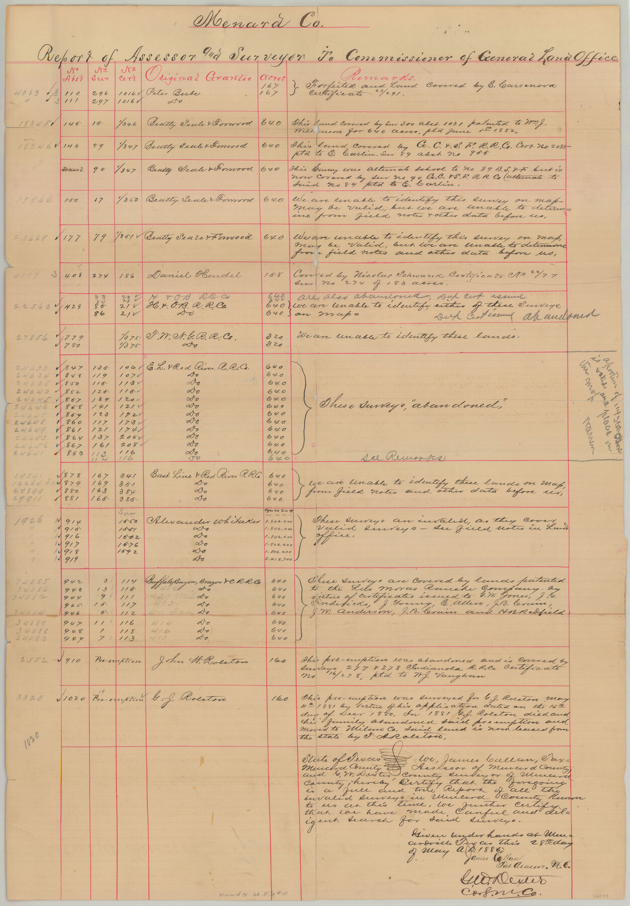
Menard County Sketch File 10
Report & Letter of Surveys in Menard County, Texas
-
Map/Doc
12074
-
Collection
General Map Collection
-
Object Dates
8/11/1885 (Creation Date)
1885 (File Date)
5/1885 (Survey Date)
8/11/1885 (Correspondence Date)
-
People and Organizations
G.W. Dexter (Surveyor/Engineer)
-
Counties
Menard
-
Subjects
Surveying Sketch File
-
Height x Width
32.5 x 18.0 inches
82.6 x 45.7 cm
-
Medium
paper, manuscript
Part of: General Map Collection
Flight Mission No. DQO-1K, Frame 113, Galveston County

Print $20.00
- Digital $50.00
Flight Mission No. DQO-1K, Frame 113, Galveston County
1952
Size 18.9 x 22.7 inches
Map/Doc 84991
Brewster County Rolled Sketch 136

Print $20.00
- Digital $50.00
Brewster County Rolled Sketch 136
Size 21.4 x 13.2 inches
Map/Doc 5304
Flight Mission No. DCL-5C, Frame 69, Kenedy County

Print $20.00
- Digital $50.00
Flight Mission No. DCL-5C, Frame 69, Kenedy County
1943
Size 18.5 x 22.3 inches
Map/Doc 85852
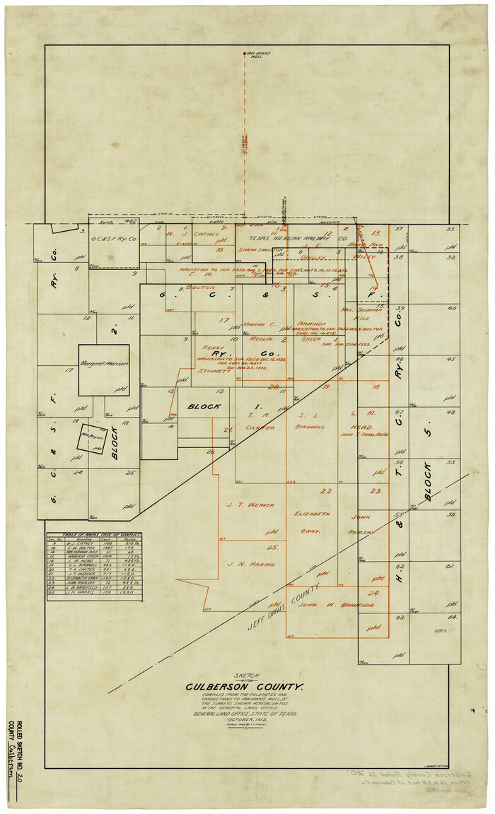
Culberson County Rolled Sketch 20
Print $20.00
- Digital $50.00
Culberson County Rolled Sketch 20
1912
Size 30.0 x 18.2 inches
Map/Doc 5653
Intracoastal Waterway in Texas - Corpus Christi to Point Isabel including Arroyo Colorado to Mo. Pac. R.R. Bridge Near Harlingen

Print $20.00
- Digital $50.00
Intracoastal Waterway in Texas - Corpus Christi to Point Isabel including Arroyo Colorado to Mo. Pac. R.R. Bridge Near Harlingen
1933
Size 40.6 x 28.0 inches
Map/Doc 61877
Bowie County Rolled Sketch 4

Print $20.00
- Digital $50.00
Bowie County Rolled Sketch 4
Size 46.1 x 43.6 inches
Map/Doc 8456
Hall County Rolled Sketch D2

Print $20.00
- Digital $50.00
Hall County Rolled Sketch D2
Size 19.0 x 22.1 inches
Map/Doc 6055
Edwards County Working Sketch 78

Print $20.00
- Digital $50.00
Edwards County Working Sketch 78
1962
Size 26.5 x 22.1 inches
Map/Doc 68954
North Sulphur River, Sims Crossing Sheet

Print $20.00
- Digital $50.00
North Sulphur River, Sims Crossing Sheet
1924
Size 12.4 x 25.1 inches
Map/Doc 78335
Gregg County Rolled Sketch 9

Print $20.00
- Digital $50.00
Gregg County Rolled Sketch 9
1933
Size 38.0 x 29.8 inches
Map/Doc 6034
Gregg County Rolled Sketch 12

Print $40.00
- Digital $50.00
Gregg County Rolled Sketch 12
1939
Size 49.5 x 55.5 inches
Map/Doc 9065
Flight Mission No. CGI-3N, Frame 125, Cameron County

Print $20.00
- Digital $50.00
Flight Mission No. CGI-3N, Frame 125, Cameron County
1954
Size 18.6 x 22.2 inches
Map/Doc 84598
You may also like
[Surveys in the Bexar District along the Guadalupe River]
![124, [Surveys in the Bexar District along the Guadalupe River], General Map Collection](https://historictexasmaps.com/wmedia_w700/maps/124.tif.jpg)
Print $3.00
- Digital $50.00
[Surveys in the Bexar District along the Guadalupe River]
1841
Size 17.2 x 10.8 inches
Map/Doc 124
Jeff Davis County Sketch File 35

Print $20.00
- Digital $50.00
Jeff Davis County Sketch File 35
1950
Size 20.6 x 19.2 inches
Map/Doc 11866
[Surveys along the San Marcos River]
![158, [Surveys along the San Marcos River], General Map Collection](https://historictexasmaps.com/wmedia_w700/maps/158.tif.jpg)
Print $2.00
- Digital $50.00
[Surveys along the San Marcos River]
Size 7.7 x 5.8 inches
Map/Doc 158
Houston County Working Sketch 35

Print $20.00
- Digital $50.00
Houston County Working Sketch 35
1999
Size 27.8 x 29.0 inches
Map/Doc 66265
Dimmit County Working Sketch 14

Print $20.00
- Digital $50.00
Dimmit County Working Sketch 14
1941
Size 27.4 x 30.1 inches
Map/Doc 68675
Revised Sectional Map Number 2, Lands in Texas and Pacific Railway Reservation From Westbrook Station in Mitchell County to Metz Station in Ector County

Print $20.00
- Digital $50.00
Revised Sectional Map Number 2, Lands in Texas and Pacific Railway Reservation From Westbrook Station in Mitchell County to Metz Station in Ector County
Size 25.1 x 19.6 inches
Map/Doc 91366
San Jacinto County Working Sketch 21

Print $20.00
- Digital $50.00
San Jacinto County Working Sketch 21
1939
Size 32.1 x 25.5 inches
Map/Doc 63734
Brown County Sketch File 12b

Print $4.00
- Digital $50.00
Brown County Sketch File 12b
1870
Size 13.8 x 8.2 inches
Map/Doc 16608
Flight Mission No. DCL-6C, Frame 178, Kenedy County

Print $20.00
- Digital $50.00
Flight Mission No. DCL-6C, Frame 178, Kenedy County
1943
Size 18.7 x 22.4 inches
Map/Doc 85990
San Patricio County Sketch File 55

Print $14.00
- Digital $50.00
San Patricio County Sketch File 55
1999
Size 11.3 x 8.8 inches
Map/Doc 36394
[Sketch for Mineral Application 26543 - Sabine River, D. H. Sanford]
![65678, [Sketch for Mineral Application 26543 - Sabine River, D. H. Sanford], General Map Collection](https://historictexasmaps.com/wmedia_w700/maps/65678.tif.jpg)
Print $40.00
- Digital $50.00
[Sketch for Mineral Application 26543 - Sabine River, D. H. Sanford]
1931
Size 73.0 x 30.3 inches
Map/Doc 65678
Flight Mission No. BRA-17M, Frame 6, Jefferson County

Print $20.00
- Digital $50.00
Flight Mission No. BRA-17M, Frame 6, Jefferson County
1953
Size 18.5 x 22.2 inches
Map/Doc 85787