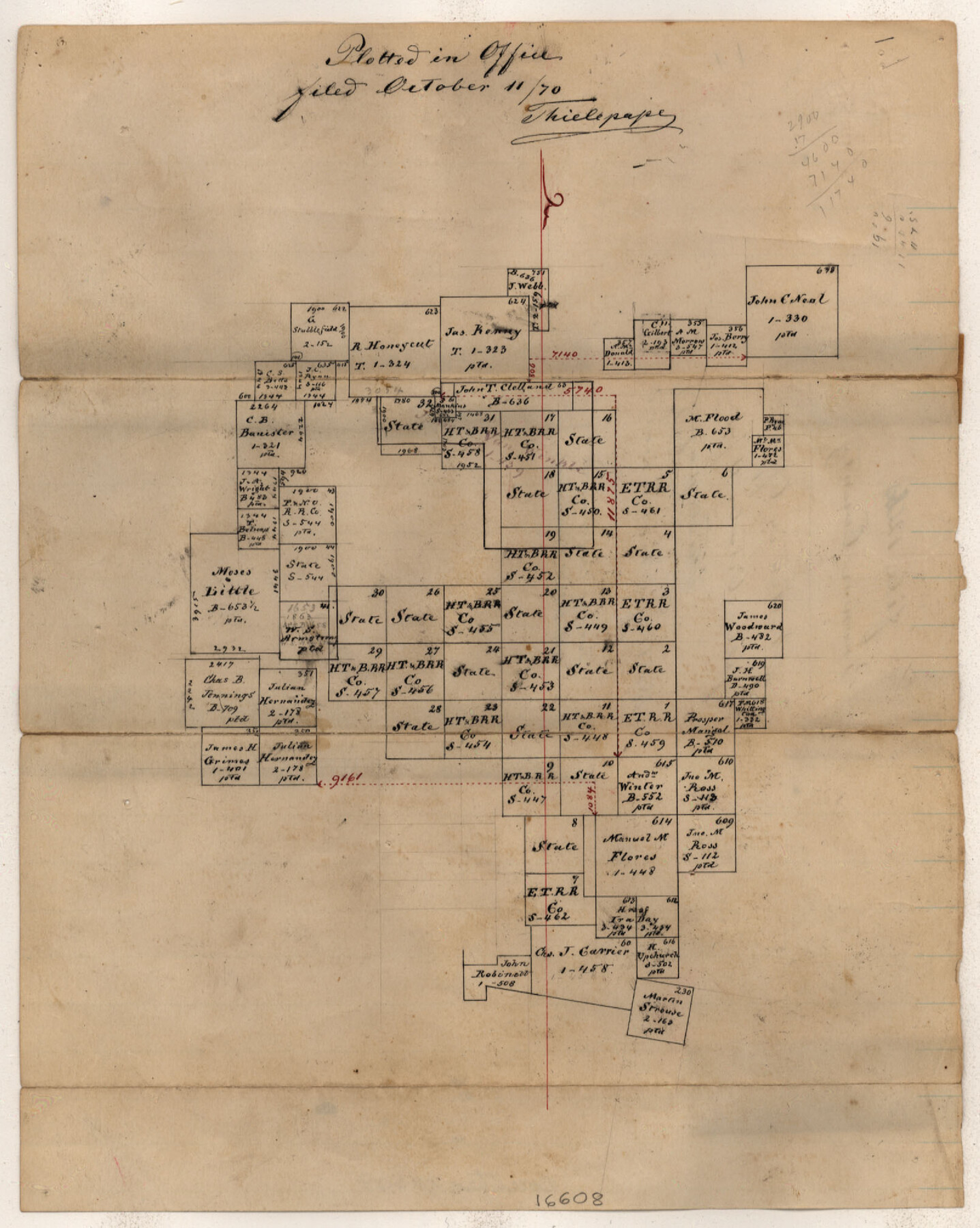
Brown County Sketch File 12b
[Office sketch of surveys west and north of Brownwood]
-
Map/Doc
16608
-
Collection
General Map Collection
-
Object Dates
1870/10/11 (Creation Date)
1870/10/11 (File Date)
-
Counties
Brown
-
Subjects
Surveying Sketch File
-
Height x Width
13.8 x 8.2 inches
35.1 x 20.8 cm
-
Medium
paper, manuscript
Part of: General Map Collection
Preliminary survey of the entrance to the Rio Grande, Texas

Print $20.00
- Digital $50.00
Preliminary survey of the entrance to the Rio Grande, Texas
1854
Size 18.2 x 22.6 inches
Map/Doc 94073
Kendall County Boundary File 2b

Print $4.00
- Digital $50.00
Kendall County Boundary File 2b
Size 10.0 x 8.0 inches
Map/Doc 55754

El Paso County Working Sketch Graphic Index - south part

Print $20.00
- Digital $50.00
El Paso County Working Sketch Graphic Index - south part
1977
Size 33.4 x 44.9 inches
Map/Doc 76537
Winkler County Rolled Sketch 10

Print $40.00
- Digital $50.00
Winkler County Rolled Sketch 10
1958
Size 29.4 x 55.9 inches
Map/Doc 10151
Kerr County Sketch File 5

Print $4.00
- Digital $50.00
Kerr County Sketch File 5
1878
Size 14.2 x 8.4 inches
Map/Doc 28865
Brazos River, Darrington-Ramsey Farms Project

Print $20.00
- Digital $50.00
Brazos River, Darrington-Ramsey Farms Project
1930
Size 37.5 x 26.8 inches
Map/Doc 69677
Starr County Working Sketch 27

Print $20.00
- Digital $50.00
Starr County Working Sketch 27
1994
Size 29.6 x 30.3 inches
Map/Doc 63943
Flight Mission No. BRA-3M, Frame 130, Jefferson County

Print $20.00
- Digital $50.00
Flight Mission No. BRA-3M, Frame 130, Jefferson County
1953
Size 18.6 x 22.3 inches
Map/Doc 85404
Knox County Working Sketch 1

Print $20.00
- Digital $50.00
Knox County Working Sketch 1
1899
Size 32.7 x 25.4 inches
Map/Doc 70243
Flight Mission No. BRE-2P, Frame 19, Nueces County

Print $20.00
- Digital $50.00
Flight Mission No. BRE-2P, Frame 19, Nueces County
1956
Size 18.4 x 22.2 inches
Map/Doc 86728
San Patricio County Working Sketch 12

Print $40.00
- Digital $50.00
San Patricio County Working Sketch 12
Size 51.4 x 40.7 inches
Map/Doc 63774
You may also like
Travis County Boundary File 5

Print $62.00
- Digital $50.00
Travis County Boundary File 5
Size 9.1 x 4.4 inches
Map/Doc 59430
General Highway Map, Brooks County, Texas

Print $20.00
General Highway Map, Brooks County, Texas
1961
Size 18.2 x 24.8 inches
Map/Doc 79388
Atascosa County Sketch File 40

Print $40.00
- Digital $50.00
Atascosa County Sketch File 40
1881
Size 15.2 x 12.6 inches
Map/Doc 13835
Map of Terry County

Print $20.00
- Digital $50.00
Map of Terry County
1902
Size 45.6 x 40.8 inches
Map/Doc 16893
Scurry County Rolled Sketch 3

Print $40.00
- Digital $50.00
Scurry County Rolled Sketch 3
Size 50.2 x 46.7 inches
Map/Doc 9912
Presidio County Rolled Sketch 82

Print $20.00
- Digital $50.00
Presidio County Rolled Sketch 82
1943
Size 35.5 x 26.1 inches
Map/Doc 7369
St. Louis Southwestern Railway of Texas

Print $20.00
- Digital $50.00
St. Louis Southwestern Railway of Texas
1900
Size 21.6 x 29.9 inches
Map/Doc 64446
Jefferson County Sketch File 51

Print $10.00
- Digital $50.00
Jefferson County Sketch File 51
Size 10.0 x 6.7 inches
Map/Doc 28249
[Brooks & Burleson Block 4, Hartley County]
![5037, [Brooks & Burleson Block 4, Hartley County], Maddox Collection](https://historictexasmaps.com/wmedia_w700/maps/5037.tif.jpg)
Print $3.00
- Digital $50.00
[Brooks & Burleson Block 4, Hartley County]
Size 10.3 x 9.5 inches
Map/Doc 5037
Frio County Working Sketch 20

Print $20.00
- Digital $50.00
Frio County Working Sketch 20
1985
Size 36.3 x 36.0 inches
Map/Doc 69294
Map of Kimble County, 1860

Print $20.00
- Digital $50.00
Map of Kimble County, 1860
1860
Size 20.7 x 30.5 inches
Map/Doc 3769
Flight Mission No. BRE-1P, Frame 32, Nueces County

Print $20.00
- Digital $50.00
Flight Mission No. BRE-1P, Frame 32, Nueces County
1956
Size 18.4 x 22.6 inches
Map/Doc 86628