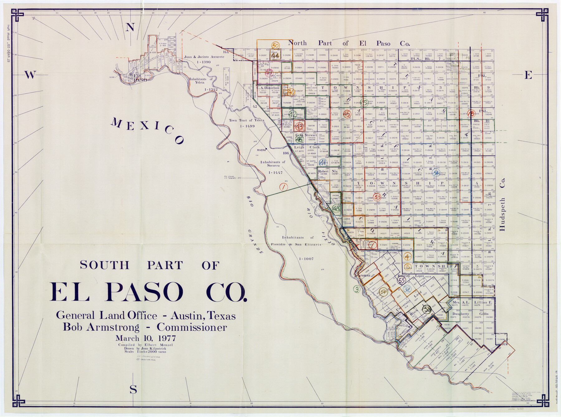
El Paso County Working Sketch Graphic Index - south part
-
Map/Doc
76537
-
Collection
General Map Collection
-
Object Dates
3/10/1977 (Creation Date)
-
People and Organizations
Elbert Menzel (Compiler)
Joan Kilpatrick (Draftsman)
-
Counties
El Paso
-
Subjects
County Surveying Working Sketch
-
Height x Width
33.4 x 44.9 inches
84.8 x 114.1 cm
-
Scale
1" = 2000 varas
Part of: General Map Collection
Wichita County Sketch File 8

Print $4.00
- Digital $50.00
Wichita County Sketch File 8
1860
Size 11.7 x 8.2 inches
Map/Doc 40048
Portion of States Submerged Area in Matagorda Bay

Print $20.00
- Digital $50.00
Portion of States Submerged Area in Matagorda Bay
1922
Size 15.2 x 14.8 inches
Map/Doc 2953
Map of that part of Comal County in Bexar District

Print $20.00
- Digital $50.00
Map of that part of Comal County in Bexar District
Size 16.3 x 22.1 inches
Map/Doc 3431
Nolan County Sketch File 18

Print $8.00
- Digital $50.00
Nolan County Sketch File 18
Size 14.3 x 8.9 inches
Map/Doc 32489
Jasper County Sketch File 21

Print $4.00
- Digital $50.00
Jasper County Sketch File 21
Size 13.4 x 8.9 inches
Map/Doc 27820
Flight Mission No. DAG-24K, Frame 154, Matagorda County

Print $20.00
- Digital $50.00
Flight Mission No. DAG-24K, Frame 154, Matagorda County
1953
Size 18.5 x 22.2 inches
Map/Doc 86568
Map of Floyd County

Print $20.00
- Digital $50.00
Map of Floyd County
1888
Size 25.4 x 19.6 inches
Map/Doc 3547
Edwards County Working Sketch 56

Print $20.00
- Digital $50.00
Edwards County Working Sketch 56
1952
Size 23.6 x 35.7 inches
Map/Doc 68932
Lavaca County Working Sketch 19

Print $20.00
- Digital $50.00
Lavaca County Working Sketch 19
1980
Size 26.9 x 29.6 inches
Map/Doc 70372
Wise County Working Sketch 12

Print $20.00
- Digital $50.00
Wise County Working Sketch 12
1958
Size 23.0 x 29.6 inches
Map/Doc 72626
Brown County Working Sketch 1

Print $20.00
- Digital $50.00
Brown County Working Sketch 1
1918
Size 20.3 x 29.0 inches
Map/Doc 67766
Deaf Smith County Rolled Sketch 4

Print $20.00
- Digital $50.00
Deaf Smith County Rolled Sketch 4
Size 23.9 x 18.0 inches
Map/Doc 96789
You may also like
Bastrop County Working Sketch 2

Print $20.00
- Digital $50.00
Bastrop County Working Sketch 2
1913
Size 14.0 x 13.6 inches
Map/Doc 67302
Loving County Working Sketch 11

Print $40.00
- Digital $50.00
Loving County Working Sketch 11
1957
Size 21.6 x 50.9 inches
Map/Doc 70644
Travis County Sketch File 1

Print $4.00
- Digital $50.00
Travis County Sketch File 1
Size 16.1 x 12.7 inches
Map/Doc 38270
Flight Mission No. CGI-4N, Frame 25, Cameron County

Print $20.00
- Digital $50.00
Flight Mission No. CGI-4N, Frame 25, Cameron County
1954
Size 18.7 x 22.4 inches
Map/Doc 84658
Fisher County Sketch File 18

Print $12.00
- Digital $50.00
Fisher County Sketch File 18
1901
Size 8.2 x 5.5 inches
Map/Doc 22589
Railroad Track Map, H&TCRRCo., Falls County, Texas

Print $4.00
- Digital $50.00
Railroad Track Map, H&TCRRCo., Falls County, Texas
1918
Size 11.5 x 18.6 inches
Map/Doc 62850
Travis County Working Sketch 61

Print $20.00
- Digital $50.00
Travis County Working Sketch 61
1995
Size 20.9 x 24.7 inches
Map/Doc 69445
Van Zandt County Working Sketch 16

Print $20.00
- Digital $50.00
Van Zandt County Working Sketch 16
1991
Size 40.5 x 34.0 inches
Map/Doc 72266
Gray County Sketch File 8

Print $20.00
- Digital $50.00
Gray County Sketch File 8
1888
Size 17.7 x 20.7 inches
Map/Doc 11577
McLennan County Sketch File 25

Print $2.00
- Digital $50.00
McLennan County Sketch File 25
Size 8.8 x 12.3 inches
Map/Doc 31299
Flight Mission No. CRK-3P, Frame 127, Refugio County

Print $20.00
- Digital $50.00
Flight Mission No. CRK-3P, Frame 127, Refugio County
1956
Size 18.6 x 22.3 inches
Map/Doc 86915
Jack County Sketch File 4

Print $4.00
- Digital $50.00
Jack County Sketch File 4
1857
Size 9.0 x 12.7 inches
Map/Doc 27506