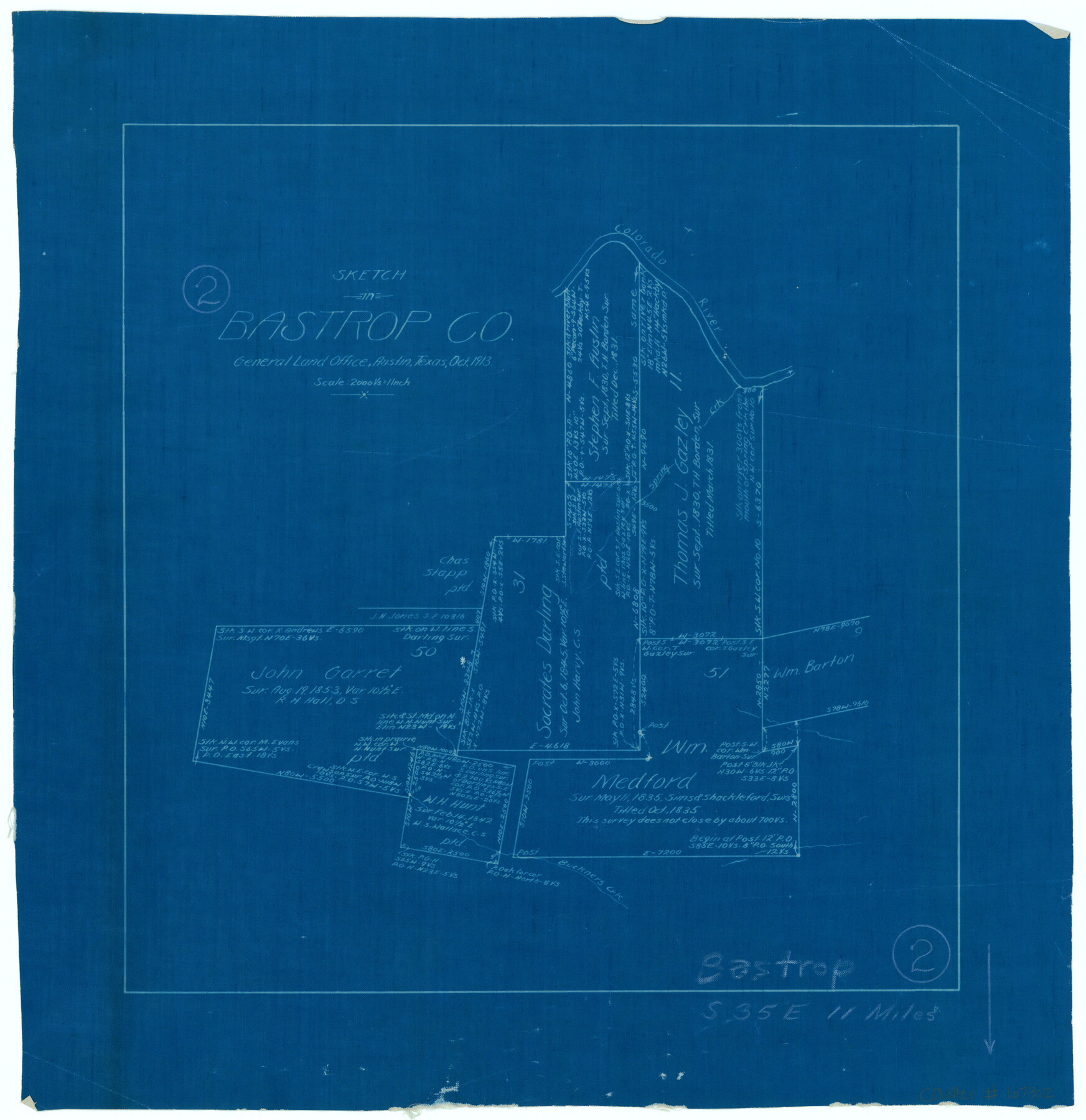
Bastrop County Working Sketch 2
-
Map/Doc
67302
-
Collection
General Map Collection
-
Object Dates
10/1913 (Creation Date)
-
Counties
Bastrop
-
Subjects
Surveying Working Sketch
-
Height x Width
14.0 x 13.6 inches
35.6 x 34.5 cm
-
Scale
1" = 2000 varas
-
Comments
Surveys located about 11 miles South 35 degrees East of Bastrop, Texas.
Part of: General Map Collection
Presidio County Rolled Sketch T-2

Print $40.00
- Digital $50.00
Presidio County Rolled Sketch T-2
Size 29.9 x 65.1 inches
Map/Doc 9804
Flight Mission No. DCL-7C, Frame 65, Kenedy County

Print $20.00
- Digital $50.00
Flight Mission No. DCL-7C, Frame 65, Kenedy County
1943
Size 18.5 x 22.3 inches
Map/Doc 86051
Gillespie County

Print $40.00
- Digital $50.00
Gillespie County
1945
Size 39.5 x 48.9 inches
Map/Doc 1838
Flight Mission No. DQN-5K, Frame 50, Calhoun County

Print $20.00
- Digital $50.00
Flight Mission No. DQN-5K, Frame 50, Calhoun County
1953
Size 18.5 x 22.3 inches
Map/Doc 84395
Hockley County Rolled Sketch 6

Print $40.00
- Digital $50.00
Hockley County Rolled Sketch 6
Size 30.6 x 48.2 inches
Map/Doc 6216
Lubbock County Sketch File 2

Print $4.00
- Digital $50.00
Lubbock County Sketch File 2
Size 4.7 x 9.2 inches
Map/Doc 30418
Presidio County Sketch File S

Print $27.00
- Digital $50.00
Presidio County Sketch File S
1917
Size 14.3 x 8.8 inches
Map/Doc 34561
Pecos County Rolled Sketch 20

Print $20.00
- Digital $50.00
Pecos County Rolled Sketch 20
Size 31.8 x 29.1 inches
Map/Doc 9685
Red River County Working Sketch 40

Print $20.00
- Digital $50.00
Red River County Working Sketch 40
1967
Size 40.1 x 35.9 inches
Map/Doc 72023

Liberty County Working Sketch 24

Print $20.00
- Digital $50.00
Liberty County Working Sketch 24
1941
Size 19.0 x 14.0 inches
Map/Doc 70483
E. N. Gustafson's survey of Northern Portion of Lake Austin, Matagorda Co., TX

Print $40.00
- Digital $50.00
E. N. Gustafson's survey of Northern Portion of Lake Austin, Matagorda Co., TX
1926
Size 43.0 x 52.5 inches
Map/Doc 2068
You may also like
Flight Mission No. CRC-1R, Frame 156, Chambers County

Print $20.00
- Digital $50.00
Flight Mission No. CRC-1R, Frame 156, Chambers County
1956
Size 18.7 x 22.5 inches
Map/Doc 84718
Kent County Boundary File 4

Print $20.00
- Digital $50.00
Kent County Boundary File 4
Size 8.8 x 4.6 inches
Map/Doc 55828
Flight Mission No. DCL-6C, Frame 114, Kenedy County

Print $20.00
- Digital $50.00
Flight Mission No. DCL-6C, Frame 114, Kenedy County
1943
Size 18.4 x 22.4 inches
Map/Doc 85944
Sectional Map No. 2 of the lands and the line of the Texas & Pacific Ry. Co. in Howard, Martin, Andrews, Midland and Tom Green Counties

Print $20.00
- Digital $50.00
Sectional Map No. 2 of the lands and the line of the Texas & Pacific Ry. Co. in Howard, Martin, Andrews, Midland and Tom Green Counties
1885
Size 18.9 x 23.4 inches
Map/Doc 4859
[T. & N. O. Railroad Company, Block 2T]
![91516, [T. & N. O. Railroad Company, Block 2T], Twichell Survey Records](https://historictexasmaps.com/wmedia_w700/maps/91516-1.tif.jpg)
Print $20.00
- Digital $50.00
[T. & N. O. Railroad Company, Block 2T]
Size 30.6 x 9.5 inches
Map/Doc 91516
Bexar County Sketch File 46

Print $40.00
- Digital $50.00
Bexar County Sketch File 46
1888
Size 24.7 x 22.6 inches
Map/Doc 10924
Howard County Working Sketch 4

Print $20.00
- Digital $50.00
Howard County Working Sketch 4
1940
Size 21.5 x 18.3 inches
Map/Doc 66270
Hunt County Sketch File 4a

Print $4.00
- Digital $50.00
Hunt County Sketch File 4a
1859
Size 12.6 x 8.2 inches
Map/Doc 27089
Freestone County Sketch File 16

Print $4.00
- Digital $50.00
Freestone County Sketch File 16
Size 6.4 x 8.7 inches
Map/Doc 23072
Map of Atascosa County

Print $20.00
- Digital $50.00
Map of Atascosa County
1879
Size 24.5 x 24.8 inches
Map/Doc 3250
Cass County Rolled Sketch 5A

Print $20.00
- Digital $50.00
Cass County Rolled Sketch 5A
Size 15.4 x 18.0 inches
Map/Doc 5411
Map of Upton County

Print $20.00
- Digital $50.00
Map of Upton County
1899
Size 47.3 x 41.1 inches
Map/Doc 16909