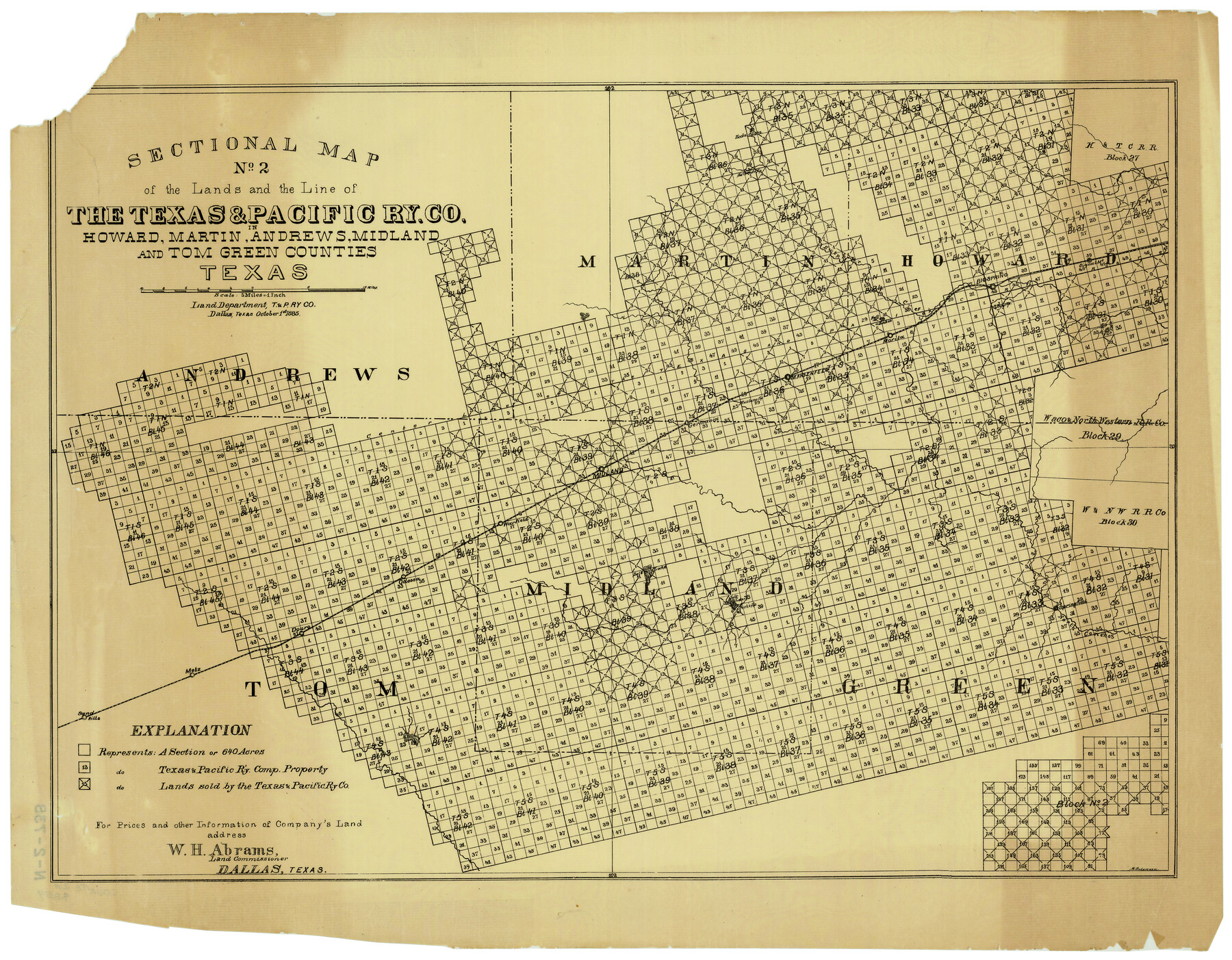
Sectional Map No. 2 of the lands and the line of the Texas & Pacific Ry. Co. in Howard, Martin, Andrews, Midland and Tom Green Counties
N-2-73
Part of: General Map Collection
San Augustine County Working Sketch 5

Print $20.00
- Digital $50.00
San Augustine County Working Sketch 5
1935
Size 39.0 x 37.4 inches
Map/Doc 63692
[Map of Surveys in Dallam, Texas]
![1768, [Map of Surveys in Dallam, Texas], General Map Collection](https://historictexasmaps.com/wmedia_w700/maps/1768.tif.jpg)
Print $20.00
- Digital $50.00
[Map of Surveys in Dallam, Texas]
1910
Size 19.5 x 27.8 inches
Map/Doc 1768
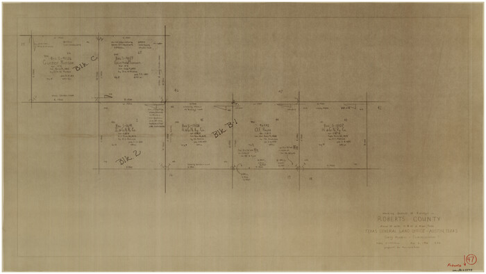
Roberts County Working Sketch 47
Print $20.00
- Digital $50.00
Roberts County Working Sketch 47
1996
Size 19.6 x 34.7 inches
Map/Doc 63573
Flight Mission No. BRA-16M, Frame 179, Jefferson County

Print $20.00
- Digital $50.00
Flight Mission No. BRA-16M, Frame 179, Jefferson County
1953
Size 18.7 x 22.2 inches
Map/Doc 85777
Map of Cameron County Drainage District Number One

Print $20.00
- Digital $50.00
Map of Cameron County Drainage District Number One
1929
Size 46.6 x 31.0 inches
Map/Doc 94245
Dawson County Working Sketch 17

Print $20.00
- Digital $50.00
Dawson County Working Sketch 17
1961
Size 33.3 x 29.9 inches
Map/Doc 68561
Medina County Sketch File 14

Print $24.00
- Digital $50.00
Medina County Sketch File 14
1914
Size 10.6 x 7.0 inches
Map/Doc 31471
Soil Map, Texas, Woodville Sheet

Print $20.00
- Digital $50.00
Soil Map, Texas, Woodville Sheet
1903
Size 13.2 x 14.3 inches
Map/Doc 3077
Anderson County Sketch File 27

Print $40.00
- Digital $50.00
Anderson County Sketch File 27
1970
Size 19.5 x 23.7 inches
Map/Doc 10806
Gaines County Sketch File 20

Print $12.00
- Digital $50.00
Gaines County Sketch File 20
1906
Size 7.1 x 8.9 inches
Map/Doc 23335
[Maps of surveys in Reeves & Culberson Cos]
![61132, [Maps of surveys in Reeves & Culberson Cos], General Map Collection](https://historictexasmaps.com/wmedia_w700/maps/61132.tif.jpg)
Print $20.00
- Digital $50.00
[Maps of surveys in Reeves & Culberson Cos]
1937
Size 30.8 x 24.9 inches
Map/Doc 61132
Topographical Map for Commerce of Dallas, Texas

Print $20.00
- Digital $50.00
Topographical Map for Commerce of Dallas, Texas
1890
Size 26.3 x 20.6 inches
Map/Doc 96792
You may also like
Hays County Working Sketch 16

Print $20.00
- Digital $50.00
Hays County Working Sketch 16
1970
Size 34.3 x 38.0 inches
Map/Doc 66090
Flight Mission No. DQN-6K, Frame 68, Calhoun County

Print $20.00
- Digital $50.00
Flight Mission No. DQN-6K, Frame 68, Calhoun County
1953
Size 18.5 x 22.1 inches
Map/Doc 84440
Louisiana and Texas Intracoastal Waterway - Dredging from Freeport Harbor to Caney Creek - Sheet 2

Print $20.00
- Digital $50.00
Louisiana and Texas Intracoastal Waterway - Dredging from Freeport Harbor to Caney Creek - Sheet 2
1940
Size 31.2 x 41.3 inches
Map/Doc 61817
Harris County Historic Topographic 25

Print $20.00
- Digital $50.00
Harris County Historic Topographic 25
1916
Size 29.2 x 22.7 inches
Map/Doc 65836
Jackson County Boundary File 2a

Print $86.00
- Digital $50.00
Jackson County Boundary File 2a
Size 14.4 x 8.8 inches
Map/Doc 55448
University Land Field Notes for Blocks A, B, C, D, E, F, G, H, I, and J in Hudspeth County

University Land Field Notes for Blocks A, B, C, D, E, F, G, H, I, and J in Hudspeth County
Map/Doc 81712
Coast Chart No. 212 - From Latitude 26° 33' to the Rio Grande Texas

Print $20.00
- Digital $50.00
Coast Chart No. 212 - From Latitude 26° 33' to the Rio Grande Texas
1886
Size 27.4 x 18.2 inches
Map/Doc 72829
San Patricio County Rolled Sketch 17

Print $20.00
- Digital $50.00
San Patricio County Rolled Sketch 17
1917
Size 18.1 x 28.1 inches
Map/Doc 7574
Hudspeth County Working Sketch 45

Print $20.00
- Digital $50.00
Hudspeth County Working Sketch 45
1983
Size 34.7 x 43.2 inches
Map/Doc 66330
Newton County Rolled Sketch 15

Print $20.00
- Digital $50.00
Newton County Rolled Sketch 15
1953
Size 26.0 x 43.7 inches
Map/Doc 6845
Hemphill County Working Sketch 26

Print $40.00
- Digital $50.00
Hemphill County Working Sketch 26
1974
Size 57.2 x 48.3 inches
Map/Doc 66121
Potter County Boundary File 2

Print $30.00
- Digital $50.00
Potter County Boundary File 2
Size 9.0 x 6.0 inches
Map/Doc 57952