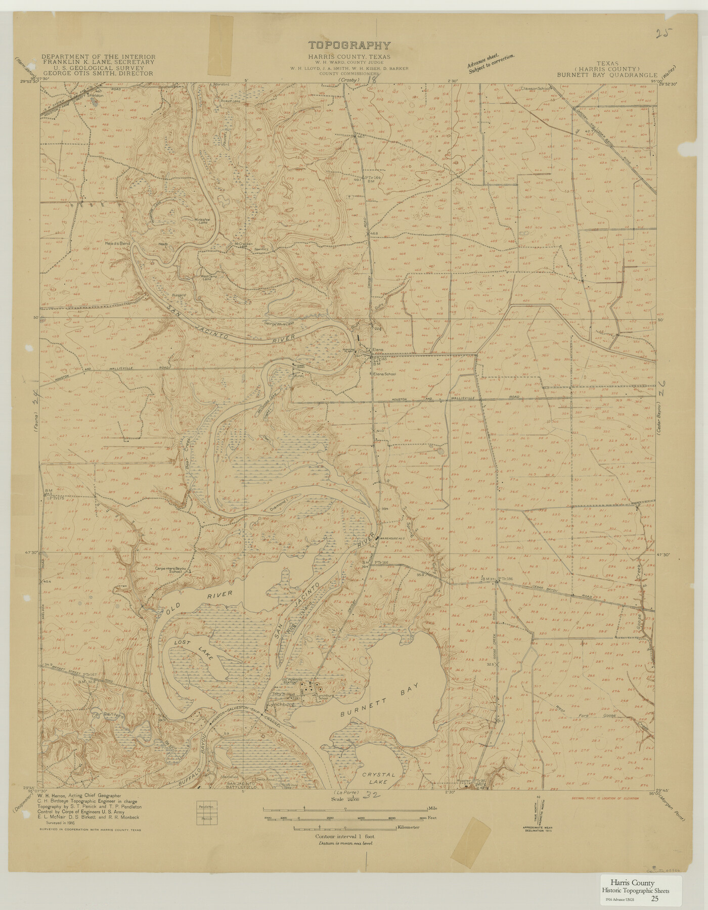
Harris County Historic Topographic 25
Burnett Bay Quadrangle
-
Map/Doc
65836
-
Collection
General Map Collection
-
Object Dates
1916 (Creation Date)
-
People and Organizations
U. S. Geological Survey (Publisher)
-
Counties
Harris
-
Subjects
Topographic
-
Height x Width
29.2 x 22.7 inches
74.2 x 57.7 cm
Part of: General Map Collection
Hydograhic Survey H-994, Corpus Christi Pass

Print $40.00
- Digital $50.00
Hydograhic Survey H-994, Corpus Christi Pass
1869
Size 32.1 x 53.5 inches
Map/Doc 2700
Flight Mission No. BQY-15M, Frame 14, Harris County

Print $20.00
- Digital $50.00
Flight Mission No. BQY-15M, Frame 14, Harris County
1953
Size 18.6 x 22.4 inches
Map/Doc 85312
Pecos County Working Sketch 90

Print $40.00
- Digital $50.00
Pecos County Working Sketch 90
1964
Size 65.3 x 26.6 inches
Map/Doc 71562
Packery Channel

Print $20.00
- Digital $50.00
Packery Channel
1958
Size 21.1 x 24.3 inches
Map/Doc 3007
Montgomery County Working Sketch 69

Print $20.00
- Digital $50.00
Montgomery County Working Sketch 69
1973
Size 27.3 x 37.7 inches
Map/Doc 71176
Burnet County Boundary File 12b

Print $8.00
- Digital $50.00
Burnet County Boundary File 12b
Size 12.8 x 8.4 inches
Map/Doc 50960
Shelby County Working Sketch 16

Print $20.00
- Digital $50.00
Shelby County Working Sketch 16
1952
Size 25.3 x 22.9 inches
Map/Doc 63869
Map of the Houston Ship Channel showing all industries, railways, public and private docks, and approximate all original surveys in the vicinity of the channel

Print $20.00
- Digital $50.00
Map of the Houston Ship Channel showing all industries, railways, public and private docks, and approximate all original surveys in the vicinity of the channel
1925
Size 14.5 x 30.2 inches
Map/Doc 4666
Swisher County Sketch File 6

Print $20.00
- Digital $50.00
Swisher County Sketch File 6
Size 15.4 x 12.1 inches
Map/Doc 12404
Navarro County Sketch File 16

Print $24.00
- Digital $50.00
Navarro County Sketch File 16
1902
Size 9.7 x 6.3 inches
Map/Doc 32330
Webb County Sketch File 8b

Print $28.00
- Digital $50.00
Webb County Sketch File 8b
1877
Size 12.9 x 8.2 inches
Map/Doc 39745
Hutchinson County Working Sketch 39

Print $20.00
- Digital $50.00
Hutchinson County Working Sketch 39
1978
Size 27.4 x 23.2 inches
Map/Doc 66399
You may also like
Presidio County Rolled Sketch WR1

Print $20.00
- Digital $50.00
Presidio County Rolled Sketch WR1
1927
Size 20.4 x 23.0 inches
Map/Doc 7421
McLennan County Sketch File 10

Print $6.00
- Digital $50.00
McLennan County Sketch File 10
1861
Size 10.3 x 15.2 inches
Map/Doc 31260
Flight Mission No. BQY-4M, Frame 37, Harris County

Print $20.00
- Digital $50.00
Flight Mission No. BQY-4M, Frame 37, Harris County
1953
Size 18.6 x 22.3 inches
Map/Doc 85252
Duval County Sketch File 36b

Print $60.00
- Digital $50.00
Duval County Sketch File 36b
1935
Size 28.4 x 23.3 inches
Map/Doc 11393
Leon County Working Sketch 10

Print $20.00
- Digital $50.00
Leon County Working Sketch 10
1951
Size 21.5 x 17.3 inches
Map/Doc 70409
Bastrop County Working Sketch 3

Print $20.00
- Digital $50.00
Bastrop County Working Sketch 3
1921
Size 22.9 x 15.4 inches
Map/Doc 67303
The Judicial District/County of DeWitt. Abolished, Spring 1842

Print $20.00
The Judicial District/County of DeWitt. Abolished, Spring 1842
2020
Size 22.4 x 21.7 inches
Map/Doc 96326
[Sketch for Mineral Applications 7410, 7411, 7412, 7413, 7712 - Kleberg County]
![65624, [Sketch for Mineral Applications 7410, 7411, 7412, 7413, 7712 - Kleberg County], General Map Collection](https://historictexasmaps.com/wmedia_w700/maps/65624-1.tif.jpg)
Print $40.00
- Digital $50.00
[Sketch for Mineral Applications 7410, 7411, 7412, 7413, 7712 - Kleberg County]
1977
Size 91.9 x 44.5 inches
Map/Doc 65624
[Surveys along Seco, Pecan and Deer Creeks]
![316, [Surveys along Seco, Pecan and Deer Creeks], General Map Collection](https://historictexasmaps.com/wmedia_w700/maps/316.tif.jpg)
Print $2.00
- Digital $50.00
[Surveys along Seco, Pecan and Deer Creeks]
1847
Size 8.9 x 7.8 inches
Map/Doc 316
Dallas County

Print $20.00
- Digital $50.00
Dallas County
1942
Size 45.1 x 37.1 inches
Map/Doc 77258
Hays County Working Sketch 19

Print $20.00
- Digital $50.00
Hays County Working Sketch 19
1980
Size 30.1 x 26.0 inches
Map/Doc 66093
Wichita County Working Sketch 20

Print $20.00
- Digital $50.00
Wichita County Working Sketch 20
1950
Size 33.2 x 23.0 inches
Map/Doc 72530