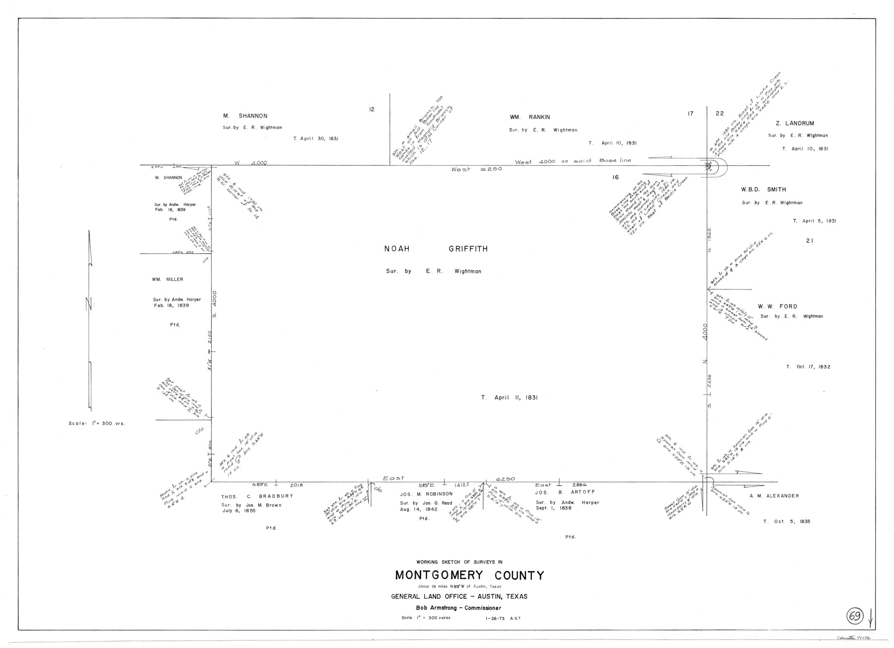
Montgomery County Working Sketch 69
-
Map/Doc
71176
-
Collection
General Map Collection
-
Object Dates
1/26/1973 (Creation Date)
-
People and Organizations
Abner G. Trigg (Draftsman)
-
Counties
Montgomery
-
Subjects
Surveying Working Sketch
-
Height x Width
27.3 x 37.7 inches
69.3 x 95.8 cm
-
Scale
1" = 300 varas
Part of: General Map Collection
Houston County Rolled Sketch 7

Print $40.00
- Digital $50.00
Houston County Rolled Sketch 7
Size 43.2 x 50.1 inches
Map/Doc 9183
Donley County Rolled Sketch 3

Print $20.00
- Digital $50.00
Donley County Rolled Sketch 3
1946
Size 15.1 x 21.9 inches
Map/Doc 5729
Northeast Part Pecos County

Print $20.00
- Digital $50.00
Northeast Part Pecos County
1975
Size 35.8 x 42.3 inches
Map/Doc 73260
Right of Way and Track Map Houston & Texas Central R.R. operated by the T. & N.O. R.R. Co., Austin Branch

Print $40.00
- Digital $50.00
Right of Way and Track Map Houston & Texas Central R.R. operated by the T. & N.O. R.R. Co., Austin Branch
1918
Size 25.8 x 58.2 inches
Map/Doc 64554
Culberson County Working Sketch 19

Print $20.00
- Digital $50.00
Culberson County Working Sketch 19
1933
Size 30.0 x 43.6 inches
Map/Doc 68471
Pecos County Sketch File 33

Print $40.00
- Digital $50.00
Pecos County Sketch File 33
1935
Size 8.9 x 20.7 inches
Map/Doc 33712
Val Verde County Working Sketch 25

Print $20.00
- Digital $50.00
Val Verde County Working Sketch 25
1934
Size 24.2 x 18.2 inches
Map/Doc 72160
Hutchinson County Working Sketch 2

Print $20.00
- Digital $50.00
Hutchinson County Working Sketch 2
Size 32.0 x 18.9 inches
Map/Doc 66360
Houston County Sketch File 38

Print $8.00
- Digital $50.00
Houston County Sketch File 38
Size 12.8 x 8.3 inches
Map/Doc 26821
Hudspeth County Working Sketch 20

Print $40.00
- Digital $50.00
Hudspeth County Working Sketch 20
1966
Size 43.8 x 63.6 inches
Map/Doc 66302
Mills County Working Sketch 10

Print $20.00
- Digital $50.00
Mills County Working Sketch 10
1928
Size 29.0 x 22.0 inches
Map/Doc 71040
Flight Mission No. BRA-6M, Frame 89, Jefferson County

Print $20.00
- Digital $50.00
Flight Mission No. BRA-6M, Frame 89, Jefferson County
1953
Size 18.6 x 22.4 inches
Map/Doc 85432
You may also like
Padre Island Under Six Flags

Print $40.00
- Digital $50.00
Padre Island Under Six Flags
1962
Size 59.3 x 30.3 inches
Map/Doc 3123
General Highway Map, Loving County, Texas

Print $20.00
General Highway Map, Loving County, Texas
1961
Size 18.1 x 24.6 inches
Map/Doc 79577
Lee County Sketch File 5

Print $40.00
- Digital $50.00
Lee County Sketch File 5
Size 12.2 x 15.8 inches
Map/Doc 29686
[Block M-23 and vicinity]
![91148, [Block M-23 and vicinity], Twichell Survey Records](https://historictexasmaps.com/wmedia_w700/maps/91148-1.tif.jpg)
Print $3.00
- Digital $50.00
[Block M-23 and vicinity]
Size 11.1 x 13.6 inches
Map/Doc 91148
Comanche County Working Sketch 8

Print $20.00
- Digital $50.00
Comanche County Working Sketch 8
1950
Size 29.1 x 24.8 inches
Map/Doc 68142

Highland Place an Addition to City of Lubbock - Plat of Lots and Street

Print $20.00
- Digital $50.00
Highland Place an Addition to City of Lubbock - Plat of Lots and Street
Size 26.0 x 18.1 inches
Map/Doc 92843
Flight Mission No. BRA-16M, Frame 51, Jefferson County

Print $20.00
- Digital $50.00
Flight Mission No. BRA-16M, Frame 51, Jefferson County
1953
Size 18.6 x 22.6 inches
Map/Doc 85668
[Texas and Pacific Railway Company, Block 44, Township One South]
![89845, [Texas and Pacific Railway Company, Block 44, Township One South], Twichell Survey Records](https://historictexasmaps.com/wmedia_w700/maps/89845-1.tif.jpg)
Print $40.00
- Digital $50.00
[Texas and Pacific Railway Company, Block 44, Township One South]
Size 42.0 x 59.2 inches
Map/Doc 89845
Hudspeth County Sketch File 17

Print $11.00
- Digital $50.00
Hudspeth County Sketch File 17
1929
Size 9.3 x 14.6 inches
Map/Doc 26954
San Augustine County Working Sketch 5

Print $20.00
- Digital $50.00
San Augustine County Working Sketch 5
1935
Size 39.0 x 37.4 inches
Map/Doc 63692
Fort Bend County Rolled Sketch 6

Print $20.00
- Digital $50.00
Fort Bend County Rolled Sketch 6
1967
Size 26.1 x 35.4 inches
Map/Doc 5897