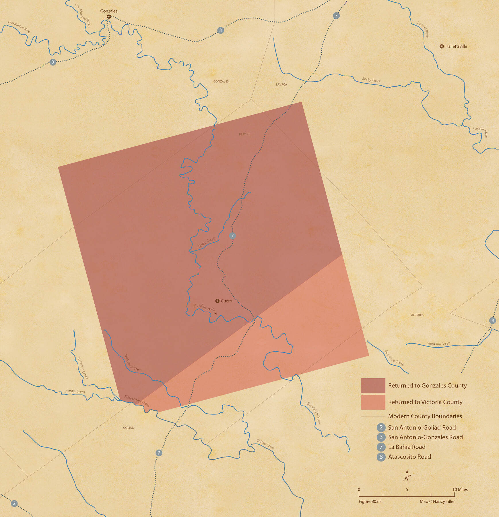
The Judicial District/County of DeWitt. Abolished, Spring 1842
Figure No. 803.2 from 'A Boundary Atlas of Texas, 1821-1845' by Jim Tiller
-
Map/Doc
96326
-
Collection
Nancy and Jim Tiller Digital Collection
-
Object Dates
2020/1/1 (Creation Date)
-
People and Organizations
Jim Tiller (Author)
Nancy Tiller (Cartographer)
Gang Gong (GIS Professional)
-
Subjects
Atlas Republic of Texas Texas Boundaries
-
Height x Width
22.4 x 21.7 inches
56.9 x 55.1 cm
-
Medium
digital image
-
Comments
To purchase a digital PDF copy of "A Boundary Atlas of Texas, 1821-1845" see 96437.
Part of: Nancy and Jim Tiller Digital Collection
The Republic County of Goliad. December 29, 1845

Print $20.00
The Republic County of Goliad. December 29, 1845
2020
Size 17.5 x 21.7 inches
Map/Doc 96152
The Empresario Grants. Arthur Goodall Wavell, Proposed Expansion

Print $20.00
The Empresario Grants. Arthur Goodall Wavell, Proposed Expansion
2020
Size 16.0 x 21.7 inches
Map/Doc 96427
Republic Counties. December 29, 1845

Print $20.00
Republic Counties. December 29, 1845
2020
Size 24.5 x 21.7 inches
Map/Doc 96319
The Republic County of Matagorda. September 17, 1838

Print $20.00
The Republic County of Matagorda. September 17, 1838
2020
Size 21.0 x 21.7 inches
Map/Doc 96217
The Republic County of Bastrop. May 24, 1838

Print $20.00
The Republic County of Bastrop. May 24, 1838
2020
Size 17.8 x 21.7 inches
Map/Doc 96090
The Republic County of Fort Bend. February 4, 1841

Print $20.00
The Republic County of Fort Bend. February 4, 1841
2020
Size 14.7 x 21.6 inches
Map/Doc 96141
The Republic County of Bowie. Created, December 17, 1840

Print $20.00
The Republic County of Bowie. Created, December 17, 1840
2020
Size 19.5 x 21.7 inches
Map/Doc 96102
The Chief Justice County of San Patricio. Lands in Conflict with Bexar County

Print $20.00
The Chief Justice County of San Patricio. Lands in Conflict with Bexar County
2020
Size 20.0 x 21.7 inches
Map/Doc 96073
The Mexican Municipality of Matagorda. December 28, 1834

Print $20.00
The Mexican Municipality of Matagorda. December 28, 1834
2020
Size 15.9 x 21.7 inches
Map/Doc 96026
The Republic County of Bowie. June 24, 1841

Print $20.00
The Republic County of Bowie. June 24, 1841
2020
Size 19.5 x 21.7 inches
Map/Doc 96104
de Leon Empresario Colony. April 15, 1824

Print $20.00
de Leon Empresario Colony. April 15, 1824
2020
Size 18.5 x 21.7 inches
Map/Doc 95988
Republic Counties. January 1, 1844

Print $20.00
Republic Counties. January 1, 1844
2020
Size 24.5 x 21.7 inches
Map/Doc 96317
You may also like
Lynn County Rolled Sketch 10

Print $20.00
- Digital $50.00
Lynn County Rolled Sketch 10
Size 13.1 x 18.5 inches
Map/Doc 6646
Hamilton County Sketch File 16

Print $20.00
- Digital $50.00
Hamilton County Sketch File 16
1898
Size 22.6 x 19.6 inches
Map/Doc 11616
[Texas Panhandle North Boundary Line]
![1714, [Texas Panhandle North Boundary Line], General Map Collection](https://historictexasmaps.com/wmedia_w700/maps/1714.tif.jpg)
Print $20.00
- Digital $50.00
[Texas Panhandle North Boundary Line]
1898
Size 43.6 x 11.4 inches
Map/Doc 1714

Map of surveys 191 & 192 T. C. R.R. Co. in Travis County, Texas

Print $20.00
- Digital $50.00
Map of surveys 191 & 192 T. C. R.R. Co. in Travis County, Texas
1915
Size 20.7 x 12.9 inches
Map/Doc 75555
Hudspeth County Rolled Sketch 18

Print $40.00
- Digital $50.00
Hudspeth County Rolled Sketch 18
1886
Size 15.7 x 105.0 inches
Map/Doc 9204
Hood County Sketch File 9

Print $26.00
- Digital $50.00
Hood County Sketch File 9
1859
Size 9.6 x 4.5 inches
Map/Doc 26586
Nueces County Rolled Sketch 43B

Print $20.00
- Digital $50.00
Nueces County Rolled Sketch 43B
Size 28.0 x 36.5 inches
Map/Doc 6885
[Surveys made in Peters Colony by Thomas Leckie]
![1983, [Surveys made in Peters Colony by Thomas Leckie], General Map Collection](https://historictexasmaps.com/wmedia_w700/maps/1983.tif.jpg)
Print $20.00
- Digital $50.00
[Surveys made in Peters Colony by Thomas Leckie]
1858
Size 22.9 x 16.6 inches
Map/Doc 1983
Section 148 Block G Abstract 1639 Cert. 57 Gaines County

Print $20.00
- Digital $50.00
Section 148 Block G Abstract 1639 Cert. 57 Gaines County
Size 13.0 x 13.7 inches
Map/Doc 93228
San Benito, Texas on the Frisco in the Lower Rio Grande Valley

San Benito, Texas on the Frisco in the Lower Rio Grande Valley
1911
Map/Doc 96727
Map of League City and Subdivisions comprising the M. Muldoon 2 League Grant and part of the S.F. Austin League east of G. H. & H. R.R.

Print $20.00
- Digital $50.00
Map of League City and Subdivisions comprising the M. Muldoon 2 League Grant and part of the S.F. Austin League east of G. H. & H. R.R.
1893
Size 27.7 x 37.4 inches
Map/Doc 87500