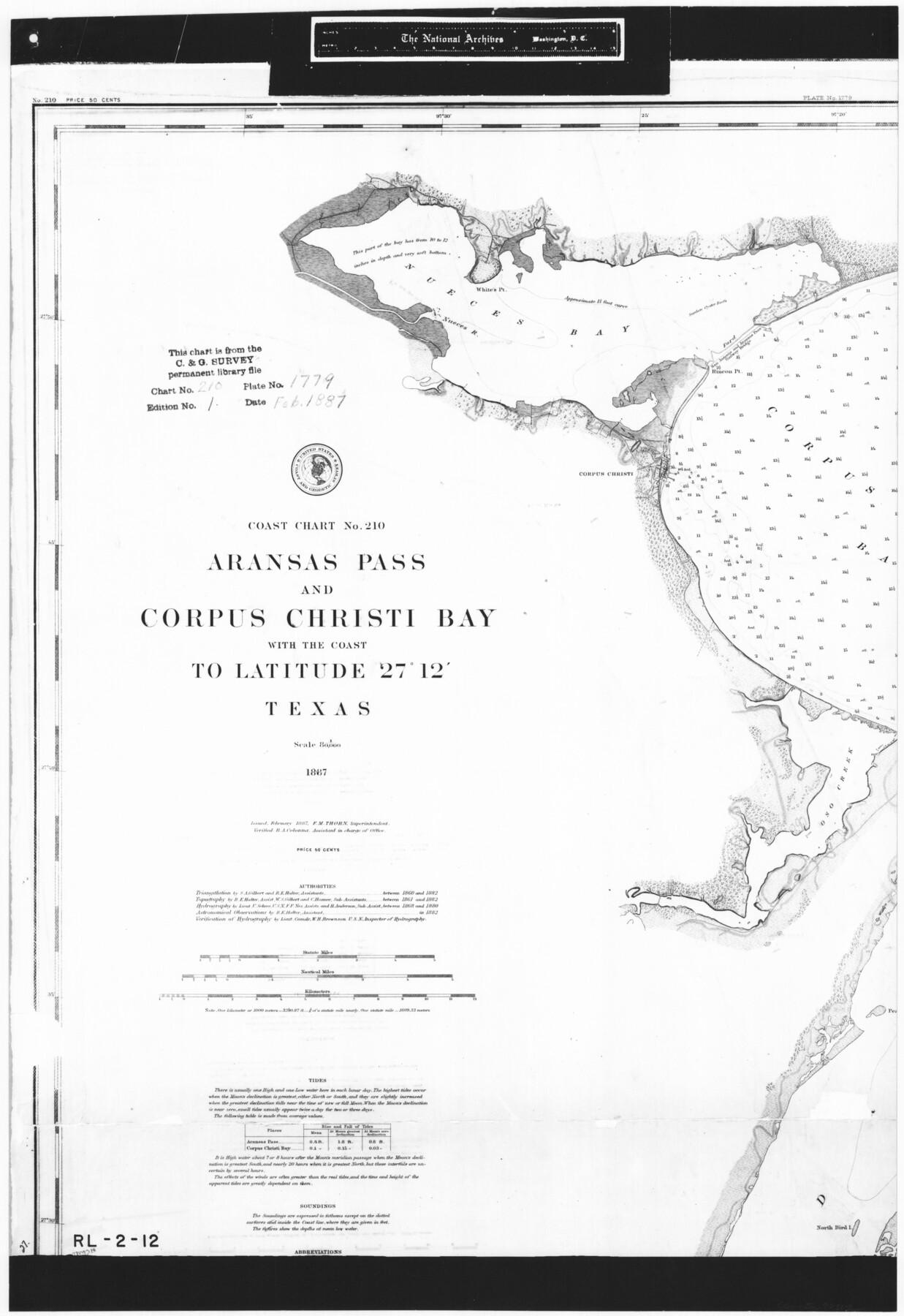
Coast Chart No. 210 Aransas Pass and Corpus Christi Bay with the coast to latitude 27° 12' Texas
RL-2-12
-
Map/Doc
72809
-
Collection
General Map Collection
-
Object Dates
1887 (Creation Date)
-
People and Organizations
[U. S. Coast and Geodetic Survey] (Publisher)
-
Counties
Nueces
-
Subjects
Nautical Charts
-
Height x Width
26.6 x 18.3 inches
67.6 x 46.5 cm
-
Comments
B/W photostat copy from National Archives in multiple pieces.
Part of: General Map Collection
Val Verde County Working Sketch 41

Print $20.00
- Digital $50.00
Val Verde County Working Sketch 41
1943
Size 27.8 x 30.2 inches
Map/Doc 72176
Lavaca County Sketch File 7

Print $4.00
- Digital $50.00
Lavaca County Sketch File 7
1873
Size 7.9 x 9.8 inches
Map/Doc 29642
Fayette County

Print $40.00
- Digital $50.00
Fayette County
1978
Size 42.8 x 54.5 inches
Map/Doc 77278
Jeff Davis County Working Sketch Graphic Index - central part

Print $40.00
- Digital $50.00
Jeff Davis County Working Sketch Graphic Index - central part
1982
Size 55.7 x 42.6 inches
Map/Doc 76593
Anderson County Working Sketch 3

Print $20.00
- Digital $50.00
Anderson County Working Sketch 3
Size 15.4 x 14.1 inches
Map/Doc 67002
Austin County Boundary File 4

Print $10.00
- Digital $50.00
Austin County Boundary File 4
Size 14.1 x 8.6 inches
Map/Doc 50244
Map of Kinney County

Print $20.00
- Digital $50.00
Map of Kinney County
1888
Size 27.5 x 26.1 inches
Map/Doc 3779
Terrell County Working Sketch 77

Print $20.00
- Digital $50.00
Terrell County Working Sketch 77
1983
Size 22.9 x 33.7 inches
Map/Doc 69598
Brazoria County Sketch File 6a

Print $40.00
- Digital $50.00
Brazoria County Sketch File 6a
1862
Size 17.6 x 12.6 inches
Map/Doc 10949
Lipscomb County Rolled Sketch 6

Print $20.00
- Digital $50.00
Lipscomb County Rolled Sketch 6
1941
Size 44.8 x 21.8 inches
Map/Doc 42260
Flight Mission No. BQR-13K, Frame 117, Brazoria County

Print $20.00
- Digital $50.00
Flight Mission No. BQR-13K, Frame 117, Brazoria County
1952
Size 18.6 x 22.4 inches
Map/Doc 84078
Aransas County Sketch File 12

Print $8.00
- Digital $50.00
Aransas County Sketch File 12
Size 14.0 x 8.7 inches
Map/Doc 13118
You may also like
Titus County Sketch File 2

Print $4.00
- Digital $50.00
Titus County Sketch File 2
Size 8.2 x 10.1 inches
Map/Doc 38132
Maverick County Sketch File 10

Print $22.00
- Digital $50.00
Maverick County Sketch File 10
Size 8.6 x 7.0 inches
Map/Doc 31072
Tyler County Working Sketch 3

Print $20.00
- Digital $50.00
Tyler County Working Sketch 3
1922
Size 28.0 x 32.6 inches
Map/Doc 69473
Galveston County Rolled Sketch Z61

Print $20.00
- Digital $50.00
Galveston County Rolled Sketch Z61
1934
Size 34.9 x 23.0 inches
Map/Doc 5993
Hardin County Sketch File 60

Print $8.00
- Digital $50.00
Hardin County Sketch File 60
Size 14.4 x 8.9 inches
Map/Doc 25234
Collin County Working Sketch 4

Print $20.00
- Digital $50.00
Collin County Working Sketch 4
1953
Size 20.4 x 21.8 inches
Map/Doc 68098
Randall County

Print $20.00
- Digital $50.00
Randall County
1958
Size 41.0 x 33.0 inches
Map/Doc 77402
The Republic County of Bexar. North View. Proposed, Fall 1837-December 31, 1838

Print $20.00
The Republic County of Bexar. North View. Proposed, Fall 1837-December 31, 1838
2020
Size 14.0 x 21.1 inches
Map/Doc 96094
Leon County Sketch File 35-1

Print $28.00
- Digital $50.00
Leon County Sketch File 35-1
1966
Size 14.1 x 8.6 inches
Map/Doc 29836
Gregg County Sketch File 1B

Print $4.00
- Digital $50.00
Gregg County Sketch File 1B
1848
Size 12.8 x 8.4 inches
Map/Doc 24538
Crockett County Rolled Sketch 58

Print $20.00
- Digital $50.00
Crockett County Rolled Sketch 58
Size 19.0 x 32.8 inches
Map/Doc 5600
Brewster County Rolled Sketch 24D

Print $20.00
- Digital $50.00
Brewster County Rolled Sketch 24D
1909
Size 14.6 x 17.4 inches
Map/Doc 5211