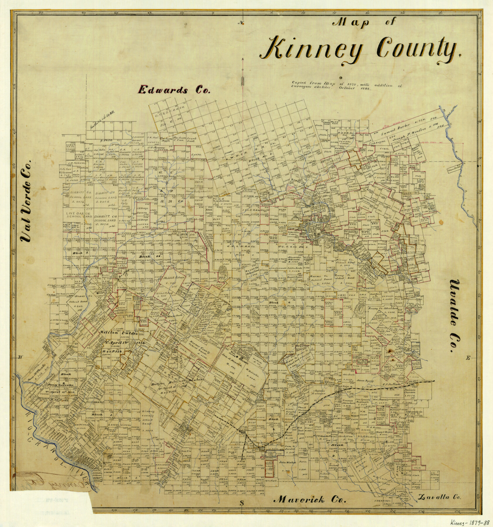
Map of Kinney County
-
Map/Doc
3779
-
Collection
General Map Collection
-
Object Dates
10/1888 (Creation Date)
-
Counties
Kinney
-
Subjects
County
-
Height x Width
27.5 x 26.1 inches
69.9 x 66.3 cm
-
Comments
Note on Map: "Copied from Map of 1879 with additions of Surveyors' sketches, October 1888".
-
Features
East Prong of Nueces River
Nueces River
Battleground August 10, 1863
Silver Lake
Gladesburg
Piedra Pintos Creek
Fort Clark
Brackett
Eagle Pass Junction
Dixie
Rio Grande
Antonio Mountains
Part of: General Map Collection
Armstrong County Sketch File A-1

Print $40.00
- Digital $50.00
Armstrong County Sketch File A-1
Size 28.1 x 34.3 inches
Map/Doc 10842
Flight Mission No. DQN-3K, Frame 72, Calhoun County

Print $20.00
- Digital $50.00
Flight Mission No. DQN-3K, Frame 72, Calhoun County
1953
Size 16.2 x 16.1 inches
Map/Doc 84363
Current Miscellaneous File 78

Print $22.00
- Digital $50.00
Current Miscellaneous File 78
1954
Size 10.7 x 8.4 inches
Map/Doc 74199
Live Oak County Sketch File 20

Print $14.00
- Digital $50.00
Live Oak County Sketch File 20
1898
Size 11.4 x 8.8 inches
Map/Doc 30290
Kent County Boundary File 11

Print $4.00
- Digital $50.00
Kent County Boundary File 11
Size 13.9 x 8.8 inches
Map/Doc 55895
Jackson County

Print $20.00
- Digital $50.00
Jackson County
1920
Size 46.9 x 40.8 inches
Map/Doc 77324
Dallas County Working Sketch 9

Print $20.00
- Digital $50.00
Dallas County Working Sketch 9
1960
Size 23.1 x 20.0 inches
Map/Doc 68575
Guadalupe County Sketch File 15e

Print $6.00
- Digital $50.00
Guadalupe County Sketch File 15e
Size 9.9 x 8.1 inches
Map/Doc 24707
Flight Mission No. CGI-3N, Frame 104, Cameron County

Print $20.00
- Digital $50.00
Flight Mission No. CGI-3N, Frame 104, Cameron County
1954
Size 18.6 x 22.3 inches
Map/Doc 84584
Sutton County Rolled Sketch 47

Print $20.00
- Digital $50.00
Sutton County Rolled Sketch 47
Size 17.0 x 24.3 inches
Map/Doc 7888
Hood County Working Sketch 19

Print $20.00
- Digital $50.00
Hood County Working Sketch 19
1988
Size 22.7 x 18.3 inches
Map/Doc 66213
Edwards County Rolled Sketch J

Print $83.00
- Digital $50.00
Edwards County Rolled Sketch J
1918
Size 23.6 x 30.3 inches
Map/Doc 5818
You may also like
Webb County Working Sketch 88

Print $20.00
- Digital $50.00
Webb County Working Sketch 88
1982
Size 24.2 x 19.7 inches
Map/Doc 72455
Midland County Working Sketch 16

Print $40.00
- Digital $50.00
Midland County Working Sketch 16
1953
Size 61.7 x 32.6 inches
Map/Doc 70996
Freestone County Sketch File 14a

Print $6.00
- Digital $50.00
Freestone County Sketch File 14a
1861
Size 5.3 x 5.9 inches
Map/Doc 23067
Map of San Antonio Showing Original Townsite in Relation to Mission Valero

Map of San Antonio Showing Original Townsite in Relation to Mission Valero
2017
Size 11.0 x 8.5 inches
Map/Doc 94244
[North line of Hansford, Ochiltree and Lipscomb Counties]
![93190, [North line of Hansford, Ochiltree and Lipscomb Counties], Twichell Survey Records](https://historictexasmaps.com/wmedia_w700/maps/93190-1.tif.jpg)
Print $40.00
- Digital $50.00
[North line of Hansford, Ochiltree and Lipscomb Counties]
Size 89.3 x 16.8 inches
Map/Doc 93190
Coast Chart No. 212 - From Latitude 26° 33' to the Rio Grande Texas

Print $20.00
- Digital $50.00
Coast Chart No. 212 - From Latitude 26° 33' to the Rio Grande Texas
1886
Size 27.7 x 18.3 inches
Map/Doc 72828
Starr County Sketch File 28

Print $12.00
- Digital $50.00
Starr County Sketch File 28
1933
Size 11.2 x 8.8 inches
Map/Doc 36948
Brooks County Working Sketch 12

Print $20.00
- Digital $50.00
Brooks County Working Sketch 12
1943
Size 27.0 x 26.5 inches
Map/Doc 67796

Kimble County Working Sketch 76

Print $20.00
- Digital $50.00
Kimble County Working Sketch 76
1969
Size 27.7 x 41.0 inches
Map/Doc 70144

Hale County Sketch File 15

Print $20.00
- Digital $50.00
Hale County Sketch File 15
Size 22.7 x 18.6 inches
Map/Doc 11596