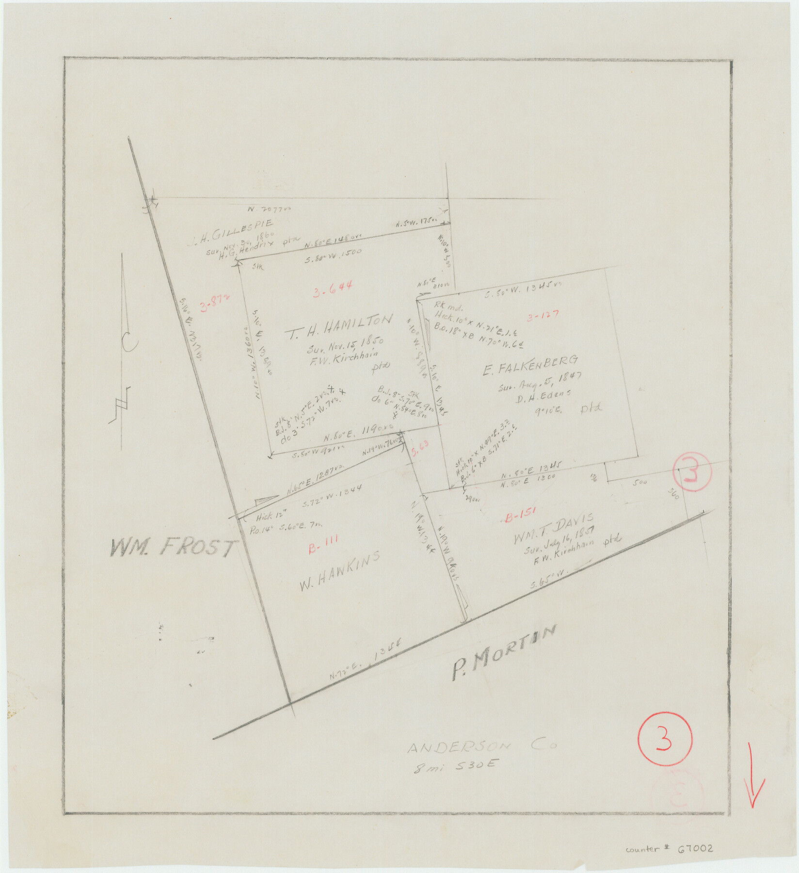
Anderson County Working Sketch 3
-
Map/Doc
67002
-
Collection
General Map Collection
-
Counties
Anderson
-
Subjects
Surveying Working Sketch
-
Height x Width
15.4 x 14.1 inches
39.1 x 35.8 cm
-
Comments
Surveys located about eight miles South 30 degrees East of Palestine, Texas.
Part of: General Map Collection
Nueces County Sketch File 59

Print $23.00
- Digital $50.00
Nueces County Sketch File 59
1989
Size 11.2 x 8.6 inches
Map/Doc 32951
Map of Dimmit County

Print $20.00
- Digital $50.00
Map of Dimmit County
1875
Size 21.9 x 24.0 inches
Map/Doc 3489
Brazoria County Working Sketch 2

Print $20.00
- Digital $50.00
Brazoria County Working Sketch 2
1907
Size 20.9 x 20.8 inches
Map/Doc 67487
[Map of Hunt County]
![3691, [Map of Hunt County], General Map Collection](https://historictexasmaps.com/wmedia_w700/maps/3691-1.tif.jpg)
Print $20.00
- Digital $50.00
[Map of Hunt County]
1851
Size 21.6 x 19.1 inches
Map/Doc 3691
Carta Marina Nvova Tavola

Print $20.00
- Digital $50.00
Carta Marina Nvova Tavola
1574
Size 9.0 x 12.4 inches
Map/Doc 97081
Castro County Working Sketch 3

Print $20.00
- Digital $50.00
Castro County Working Sketch 3
Size 31.7 x 17.9 inches
Map/Doc 67898
Atascosa County Sketch File 38

Print $40.00
- Digital $50.00
Atascosa County Sketch File 38
Size 16.3 x 23.8 inches
Map/Doc 10868
Robertson County Rolled Sketch 5

Print $20.00
- Digital $50.00
Robertson County Rolled Sketch 5
1976
Size 34.1 x 36.4 inches
Map/Doc 9864

Stephens County Sketch File 20

Print $20.00
- Digital $50.00
Stephens County Sketch File 20
Size 19.2 x 36.7 inches
Map/Doc 12350
Kleberg County Rolled Sketch 11

Print $20.00
- Digital $50.00
Kleberg County Rolled Sketch 11
1915
Size 21.0 x 26.5 inches
Map/Doc 6552
Crockett County Sketch File 69

Print $6.00
- Digital $50.00
Crockett County Sketch File 69
1931
Size 14.5 x 8.9 inches
Map/Doc 19855
You may also like
Amistad International Reservoir on Rio Grande 110

Print $20.00
- Digital $50.00
Amistad International Reservoir on Rio Grande 110
1950
Size 41.4 x 29.5 inches
Map/Doc 75541
Culberson County Rolled Sketch 56

Print $37.00
- Digital $50.00
Culberson County Rolled Sketch 56
1972
Size 11.0 x 15.6 inches
Map/Doc 44267
[Various County School Lands]
![89928, [Various County School Lands], Twichell Survey Records](https://historictexasmaps.com/wmedia_w700/maps/89928-1.tif.jpg)
Print $40.00
- Digital $50.00
[Various County School Lands]
Size 57.6 x 42.9 inches
Map/Doc 89928
Bexar County Sketch File 42a

Print $4.00
- Digital $50.00
Bexar County Sketch File 42a
Size 8.0 x 9.6 inches
Map/Doc 14520
Andrews County Boundary File 3

Print $8.00
- Digital $50.00
Andrews County Boundary File 3
Size 7.2 x 8.6 inches
Map/Doc 49717
Henderson County

Print $40.00
- Digital $50.00
Henderson County
1922
Size 39.3 x 49.1 inches
Map/Doc 4683
Cherokee County Working Sketch 17

Print $40.00
- Digital $50.00
Cherokee County Working Sketch 17
1958
Size 81.6 x 43.3 inches
Map/Doc 67972
San Jacinto County Working Sketch 25

Print $20.00
- Digital $50.00
San Jacinto County Working Sketch 25
1943
Size 34.4 x 34.2 inches
Map/Doc 63738
Atascosa County Sketch File 41

Print $8.00
- Digital $50.00
Atascosa County Sketch File 41
1956
Size 11.3 x 8.8 inches
Map/Doc 13837
Henderson County Rolled Sketch 11

Print $20.00
- Digital $50.00
Henderson County Rolled Sketch 11
1915
Size 28.9 x 42.5 inches
Map/Doc 75959
Railroad Track Map, T&PRRCo., Culberson County, Texas

Print $4.00
- Digital $50.00
Railroad Track Map, T&PRRCo., Culberson County, Texas
1910
Size 11.7 x 18.6 inches
Map/Doc 62830
Wichita County Sketch File 4

Print $20.00
- Digital $50.00
Wichita County Sketch File 4
1856
Size 9.8 x 33.2 inches
Map/Doc 76764