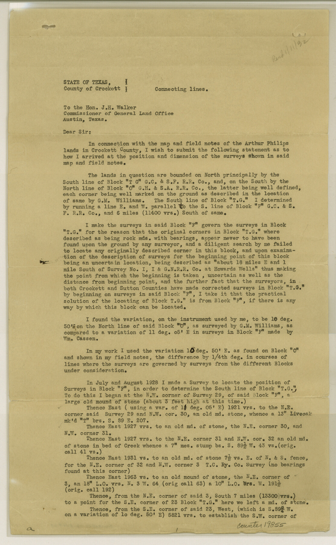
Crockett County Sketch File 69
[Connecting line of Blocks G, TG, O and OOO]
-
Map/Doc
19855
-
Collection
General Map Collection
-
Object Dates
1931/12/7 (Creation Date)
1932/1/11 (File Date)
1931/11/2 (Survey Date)
-
People and Organizations
Goodfellow (Surveyor/Engineer)
-
Counties
Crockett
-
Subjects
Surveying Sketch File
-
Height x Width
14.5 x 8.9 inches
36.8 x 22.6 cm
-
Medium
paper, print
-
Features
Howard's Well
Part of: General Map Collection
Flight Mission No. CRE-2R, Frame 166, Jackson County

Print $20.00
- Digital $50.00
Flight Mission No. CRE-2R, Frame 166, Jackson County
1956
Size 18.5 x 22.2 inches
Map/Doc 85376
[Sketch for Mineral Application 19443 - Brazos River]
![65682, [Sketch for Mineral Application 19443 - Brazos River], General Map Collection](https://historictexasmaps.com/wmedia_w700/maps/65682.tif.jpg)
Print $40.00
- Digital $50.00
[Sketch for Mineral Application 19443 - Brazos River]
1853
Size 117.6 x 30.2 inches
Map/Doc 65682
Coleman County

Print $20.00
- Digital $50.00
Coleman County
1862
Size 22.5 x 21.6 inches
Map/Doc 3414
[Map of the dividing line between Milam and Travis Counties]
![110, [Map of the dividing line between Milam and Travis Counties], General Map Collection](https://historictexasmaps.com/wmedia_w700/maps/110.tif.jpg)
Print $20.00
- Digital $50.00
[Map of the dividing line between Milam and Travis Counties]
1841
Size 14.2 x 12.8 inches
Map/Doc 110
Matagorda County Sketch File 38

Print $20.00
- Digital $50.00
Matagorda County Sketch File 38
1904
Size 24.4 x 33.0 inches
Map/Doc 12046
Stonewall County Sketch File 22

Print $20.00
- Digital $50.00
Stonewall County Sketch File 22
1937
Size 18.8 x 23.1 inches
Map/Doc 12368
Section IX, Galveston Harbor and Bar

Print $20.00
- Digital $50.00
Section IX, Galveston Harbor and Bar
1850
Size 30.0 x 45.7 inches
Map/Doc 69855
Crockett County Sketch File 42

Print $28.00
- Digital $50.00
Crockett County Sketch File 42
Size 12.8 x 8.4 inches
Map/Doc 19755
Map of Zapata County

Print $40.00
- Digital $50.00
Map of Zapata County
1901
Size 55.1 x 47.7 inches
Map/Doc 16937
Polk County Sketch File 14a

Print $4.00
- Digital $50.00
Polk County Sketch File 14a
1863
Size 9.0 x 14.6 inches
Map/Doc 34155
Flight Mission No. DIX-6P, Frame 180, Aransas County

Print $20.00
- Digital $50.00
Flight Mission No. DIX-6P, Frame 180, Aransas County
1956
Size 19.0 x 22.6 inches
Map/Doc 83842
Calhoun County Rolled Sketch 11

Print $3.00
- Digital $50.00
Calhoun County Rolled Sketch 11
1942
Size 10.9 x 16.2 inches
Map/Doc 5462
You may also like
Runnels County Rolled Sketch 43

Print $20.00
- Digital $50.00
Runnels County Rolled Sketch 43
Size 28.3 x 45.8 inches
Map/Doc 7531
![91783, [Block M-19], Twichell Survey Records](https://historictexasmaps.com/wmedia_w700/maps/91783-1.tif.jpg)
Lamb County Rolled Sketch 8

Print $20.00
- Digital $50.00
Lamb County Rolled Sketch 8
1910
Size 40.1 x 32.8 inches
Map/Doc 10728
San Jacinto County Boundary File 1a

Print $58.00
- Digital $50.00
San Jacinto County Boundary File 1a
Size 14.5 x 8.9 inches
Map/Doc 58551
Swisher County Sketch File 1

Print $28.00
- Digital $50.00
Swisher County Sketch File 1
1884
Size 13.0 x 8.2 inches
Map/Doc 37566
Culberson County Sketch File 27a

Print $28.00
- Digital $50.00
Culberson County Sketch File 27a
Size 11.2 x 8.5 inches
Map/Doc 20266
Hays County Sketch File 9

Print $6.00
- Digital $50.00
Hays County Sketch File 9
Size 9.6 x 16.2 inches
Map/Doc 26212
Upton County Rolled Sketch 49-CF

Print $20.00
- Digital $50.00
Upton County Rolled Sketch 49-CF
1926
Size 44.9 x 32.4 inches
Map/Doc 76143
[Map of the Line of the H. & Texas Cen. Railway from the Navasota River, 72 1/2 Miles from Houston, to Corsicana in Navarro Co., 211 mls from Houston]
![64087, [Map of the Line of the H. & Texas Cen. Railway from the Navasota River, 72 1/2 Miles from Houston, to Corsicana in Navarro Co., 211 mls from Houston], General Map Collection](https://historictexasmaps.com/wmedia_w700/maps/64087.tif.jpg)
Print $40.00
- Digital $50.00
[Map of the Line of the H. & Texas Cen. Railway from the Navasota River, 72 1/2 Miles from Houston, to Corsicana in Navarro Co., 211 mls from Houston]
Size 75.6 x 39.6 inches
Map/Doc 64087
[Worksheets related to the Wilson Strickland survey and vicinity]
![91282, [Worksheets related to the Wilson Strickland survey and vicinity], Twichell Survey Records](https://historictexasmaps.com/wmedia_w700/maps/91282-1.tif.jpg)
Print $20.00
- Digital $50.00
[Worksheets related to the Wilson Strickland survey and vicinity]
Size 7.9 x 24.3 inches
Map/Doc 91282
McCulloch County Rolled Sketch 11

Print $20.00
- Digital $50.00
McCulloch County Rolled Sketch 11
1992
Size 46.3 x 40.3 inches
Map/Doc 9499
McMullen County Rolled Sketch 12

Print $20.00
- Digital $50.00
McMullen County Rolled Sketch 12
Size 26.5 x 33.2 inches
Map/Doc 6729