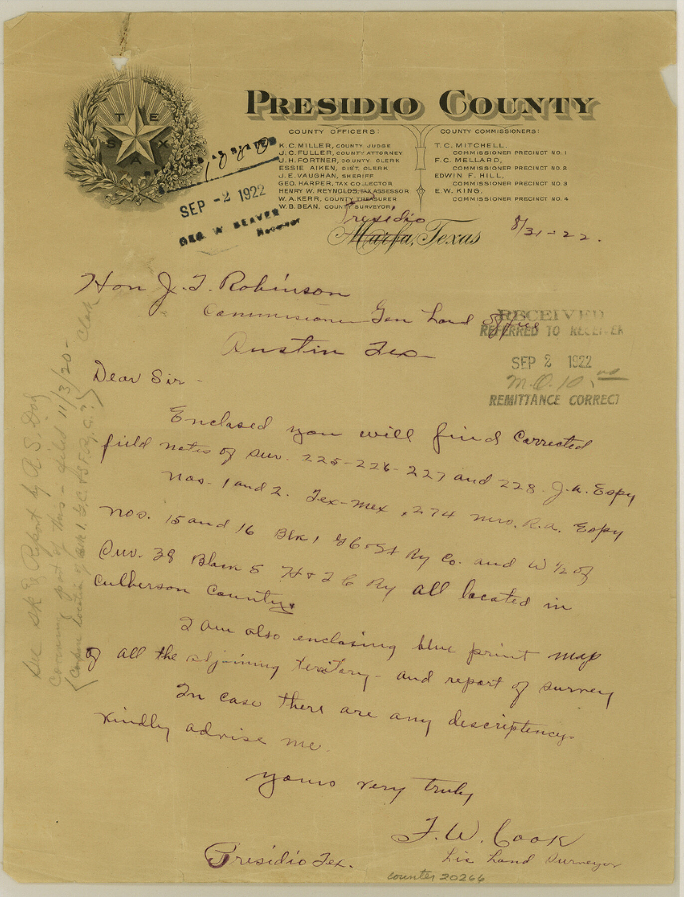
Culberson County Sketch File 27a
[Multiple sets of corrected field notes]
-
Map/Doc
20266
-
Collection
General Map Collection
-
Object Dates
1922 (File Date)
-
People and Organizations
William W. Irby (Surveyor/Engineer)
F.W. Cook (Surveyor/Engineer)
Elias Lucero (Chainman)
Frank Sowell (Chainman)
-
Counties
Culberson
-
Subjects
Surveying Sketch File
-
Height x Width
11.2 x 8.5 inches
28.4 x 21.6 cm
-
Medium
paper, manuscript
-
Features
GH&SA
Van Horn stage stop
Van Horn Wells
Lobo
Chispa Peak
Part of: General Map Collection
Harris County Rolled Sketch F

Print $40.00
- Digital $50.00
Harris County Rolled Sketch F
1933
Size 56.6 x 44.6 inches
Map/Doc 9121
Matagorda County Rolled Sketch 15

Print $20.00
- Digital $50.00
Matagorda County Rolled Sketch 15
Size 24.5 x 14.9 inches
Map/Doc 6682
Intracoastal Waterway, Houma, LA to Corpus Christi, TX

Print $5.00
- Digital $50.00
Intracoastal Waterway, Houma, LA to Corpus Christi, TX
Size 29.3 x 22.0 inches
Map/Doc 61909
San Antonio, Texas Street Map

San Antonio, Texas Street Map
1997
Size 36.5 x 46.7 inches
Map/Doc 96868
Hood County Working Sketch 12

Print $40.00
- Digital $50.00
Hood County Working Sketch 12
1978
Size 25.2 x 55.5 inches
Map/Doc 66206
Bexar County Working Sketch 15

Print $20.00
- Digital $50.00
Bexar County Working Sketch 15
1972
Size 38.3 x 43.3 inches
Map/Doc 67331
Flight Mission No. BQR-13K, Frame 118, Brazoria County

Print $20.00
- Digital $50.00
Flight Mission No. BQR-13K, Frame 118, Brazoria County
1952
Size 18.6 x 22.4 inches
Map/Doc 84079
Flight Mission No. CGI-3N, Frame 75, Cameron County

Print $20.00
- Digital $50.00
Flight Mission No. CGI-3N, Frame 75, Cameron County
1954
Size 18.6 x 22.2 inches
Map/Doc 84569
Glasscock County

Print $20.00
- Digital $50.00
Glasscock County
1933
Size 46.4 x 38.8 inches
Map/Doc 66838
Sabine Pass and mouth of the River Sabine

Print $20.00
- Digital $50.00
Sabine Pass and mouth of the River Sabine
1840
Size 27.0 x 18.3 inches
Map/Doc 72726
Gillespie County Boundary File 7

Print $18.00
- Digital $50.00
Gillespie County Boundary File 7
Size 8.6 x 4.0 inches
Map/Doc 53771
Maverick County Rolled Sketch 22

Print $20.00
- Digital $50.00
Maverick County Rolled Sketch 22
1963
Size 38.0 x 24.7 inches
Map/Doc 6714
You may also like
Flight Mission No. DIX-7P, Frame 89, Aransas County

Print $20.00
- Digital $50.00
Flight Mission No. DIX-7P, Frame 89, Aransas County
1956
Size 18.7 x 22.4 inches
Map/Doc 83883
Lipscomb County Rolled Sketch 5

Print $40.00
- Digital $50.00
Lipscomb County Rolled Sketch 5
Size 64.2 x 9.0 inches
Map/Doc 81428
Map of the Missouri Pacific and St. Louis, Iron Mountain and Southern Railways and Connections

Print $20.00
- Digital $50.00
Map of the Missouri Pacific and St. Louis, Iron Mountain and Southern Railways and Connections
1895
Size 17.8 x 31.8 inches
Map/Doc 95790
Yoakum County Rolled Sketch 1

Print $20.00
- Digital $50.00
Yoakum County Rolled Sketch 1
1939
Size 40.5 x 37.5 inches
Map/Doc 10162
Edwards County Boundary File 27b

Print $18.00
- Digital $50.00
Edwards County Boundary File 27b
Size 4.1 x 11.6 inches
Map/Doc 52887
Hudspeth County Sketch File 25

Print $10.00
- Digital $50.00
Hudspeth County Sketch File 25
1936
Size 11.3 x 8.7 inches
Map/Doc 26979
Culberson County Working Sketch 48

Print $40.00
- Digital $50.00
Culberson County Working Sketch 48
1972
Size 49.3 x 39.0 inches
Map/Doc 68502
Texas-United States Boundary Line 2

Print $22.00
- Digital $50.00
Texas-United States Boundary Line 2
1882
Size 8.3 x 7.3 inches
Map/Doc 74976
Lipscomb County Boundary File 16

Print $2.00
- Digital $50.00
Lipscomb County Boundary File 16
Size 11.5 x 7.1 inches
Map/Doc 56386
Witt Addition, Subdivision out of Section 6, Block E, City of Lubbock

Print $20.00
- Digital $50.00
Witt Addition, Subdivision out of Section 6, Block E, City of Lubbock
1950
Size 9.5 x 31.4 inches
Map/Doc 92738
Lavaca County Working Sketch 5

Print $20.00
- Digital $50.00
Lavaca County Working Sketch 5
1940
Size 21.3 x 35.2 inches
Map/Doc 70358
Gonzales County Sketch File 1

Print $4.00
- Digital $50.00
Gonzales County Sketch File 1
1858
Size 8.1 x 10.2 inches
Map/Doc 24355