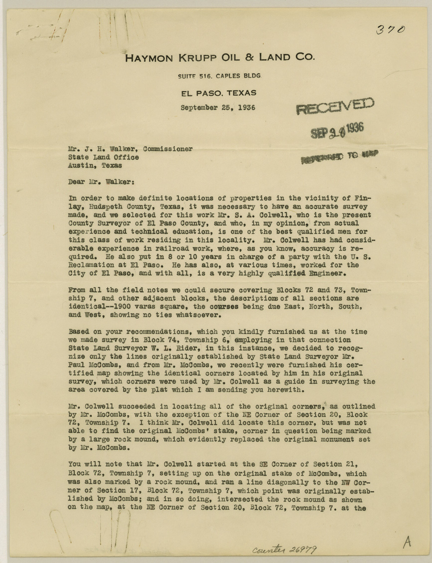
Hudspeth County Sketch File 25
[Letters from Haymon Krupp Oil and Land Company and S. A. Colwell]
- 
                          Map/Doc26979
- 
                            CollectionGeneral Map Collection
- 
                            Object Dates9/25/1936 (Creation Date)9/28/1936 (File Date)9/25/1936 (Correspondence Date)8/1936 (Survey Date)9/1936 (Survey Date)
- 
                            People and OrganizationsW.L. Rider (Surveyor/Engineer)Paul McCombs (Surveyor/Engineer)S.A. Colwell (Surveyor/Engineer)
- 
                            CountiesHudspeth
- 
                            SubjectsSurveying Sketch File
- 
                            Height x Width11.3 x 8.7 inches28.7 x 22.1 cm
- 
                            Mediumpaper, print
- 
                            FeaturesEl Paso
Part of: General Map Collection
            Madison County Working Sketch 4


                                            Print $20.00                    
                                             -                         Digital $50.00                                    
                Madison County Working Sketch 4
1973
Size 12.7 x 12.9 inches
                                Map/Doc 70766
            
            Pecos County Rolled Sketch 189


                                            Print $20.00                    
                                             -                         Digital $50.00                                    
                Pecos County Rolled Sketch 189
1998
Size 22.2 x 33.7 inches
                                Map/Doc 7307
            
            Jones County Rolled Sketch 1


                                            Print $20.00                    
                                             -                         Digital $50.00                                    
                Jones County Rolled Sketch 1
1957
Size 17.7 x 28.1 inches
                                Map/Doc 6451
            
            Frio County Sketch File 3


                                            Print $4.00                    
                                             -                         Digital $50.00                                    
                Frio County Sketch File 3
1854
Size 8.5 x 3.6 inches
                                Map/Doc 23109
            
            Schleicher County Sketch File 8


                                            Print $32.00                    
                                             -                         Digital $50.00                                    
                Schleicher County Sketch File 8
1881
Size 12.5 x 8.2 inches
                                Map/Doc 36479
            
            Runnels County Sketch File 19 and 22


                                            Print $48.00                    
                                    
                Runnels County Sketch File 19 and 22
1887
Size 14.0 x 21.2 inches
                                Map/Doc 12254
            
            Borden County Boundary File 7


                                            Print $29.00                    
                                             -                         Digital $50.00                                    
                Borden County Boundary File 7
1965
Size 11.2 x 8.8 inches
                                Map/Doc 61161
            
            Map of the Roman Empire to illustrate Ancient History, engraved for Olney's school atlas


                                            Print $20.00                    
                                             -                         Digital $50.00                                    
                Map of the Roman Empire to illustrate Ancient History, engraved for Olney's school atlas
1845
Size 12.1 x 19.0 inches
                                Map/Doc 93550
            
            DeWitt County Working Sketch 14


                                            Print $20.00                    
                                             -                         Digital $50.00                                    
                DeWitt County Working Sketch 14
1988
Size 26.3 x 29.0 inches
                                Map/Doc 68604
            
            Atascosa County Rolled Sketch R


                                            Print $20.00                    
                                             -                         Digital $50.00                                    
                Atascosa County Rolled Sketch R
Size 19.6 x 19.6 inches
                                Map/Doc 5103
            
            San Jacinto County Rolled Sketch 7


                                            Print $20.00                    
                                             -                         Digital $50.00                                    
                San Jacinto County Rolled Sketch 7
1940
Size 23.6 x 28.8 inches
                                Map/Doc 7558
            
            Township 11 South Range 13 West and 14 West, South Western District, Louisiana


                                            Print $20.00                    
                                             -                         Digital $50.00                                    
                Township 11 South Range 13 West and 14 West, South Western District, Louisiana
1838
Size 19.6 x 24.6 inches
                                Map/Doc 65854
            You may also like
            Terry County Working Sketch 3


                                            Print $40.00                    
                                             -                         Digital $50.00                                    
                Terry County Working Sketch 3
1953
Size 125.9 x 28.4 inches
                                Map/Doc 62108
            
            Sketch No. 2 [showing Block 46, Block M21, Block B4 and Block Y south of Canadian River]
            
                                    ![89929, Sketch No. 2 [showing Block 46, Block M21, Block B4 and Block Y south of Canadian River], Twichell Survey Records](https://historictexasmaps.com/wmedia_w700/maps/89929-1.tif.jpg) 


    ![89929, Sketch No. 2 [showing Block 46, Block M21, Block B4 and Block Y south of Canadian River], Twichell Survey Records](https://historictexasmaps.com/wmedia_w700/maps/89929-1.tif.jpg) 
                                
            
                                            Print $20.00                    
                                             -                         Digital $50.00                                    
                Sketch No. 2 [showing Block 46, Block M21, Block B4 and Block Y south of Canadian River]
1927
Size 36.8 x 43.7 inches
                                Map/Doc 89929
            
            Resurvey of the Original Townsite of Sundown Hockley County, Texas


                                            Print $20.00                    
                                             -                         Digital $50.00                                    
                Resurvey of the Original Townsite of Sundown Hockley County, Texas
Size 21.7 x 40.3 inches
                                Map/Doc 92234
            
            Dr. S. C. Arnett Farm Part Section 5, Block E2


                                            Print $20.00                    
                                             -                         Digital $50.00                                    
                Dr. S. C. Arnett Farm Part Section 5, Block E2
Size 12.7 x 15.8 inches
                                Map/Doc 92296
            
            Hall County Sketch File 31


                                            Print $8.00                    
                                             -                         Digital $50.00                                    
                Hall County Sketch File 31
1951
Size 14.3 x 8.9 inches
                                Map/Doc 24835
            
            Grayson County Working Sketch 13


                                            Print $20.00                    
                                             -                         Digital $50.00                                    
                Grayson County Working Sketch 13
1952
Size 31.1 x 38.0 inches
                                Map/Doc 63252
            
            Flight Mission No. DQN-5K, Frame 45, Calhoun County


                                            Print $20.00                    
                                             -                         Digital $50.00                                    
                Flight Mission No. DQN-5K, Frame 45, Calhoun County
1953
Size 18.4 x 22.1 inches
                                Map/Doc 84390
            
            Hutchinson County Rolled Sketch 6


                                            Print $20.00                    
                                             -                         Digital $50.00                                    
                Hutchinson County Rolled Sketch 6
1906
Size 33.2 x 24.2 inches
                                Map/Doc 6278
            
            Dr. Ross Trigg's Ranch [Block 29E, Townships 14N and 15N]
            
                                    ![92036, Dr. Ross Trigg's Ranch [Block 29E, Townships 14N and 15N], Twichell Survey Records](https://historictexasmaps.com/wmedia_w700/maps/92036-1.tif.jpg) 


    ![92036, Dr. Ross Trigg's Ranch [Block 29E, Townships 14N and 15N], Twichell Survey Records](https://historictexasmaps.com/wmedia_w700/maps/92036-1.tif.jpg) 
                                
            
                                            Print $20.00                    
                                             -                         Digital $50.00                                    
                Dr. Ross Trigg's Ranch [Block 29E, Townships 14N and 15N]
Size 25.8 x 19.6 inches
                                Map/Doc 92036
            
            Newton County Rolled Sketch 25


                                            Print $20.00                    
                                             -                         Digital $50.00                                    
                Newton County Rolled Sketch 25
1893
Size 22.3 x 18.6 inches
                                Map/Doc 6852
            
            Hill County Working Sketch 3


                                            Print $20.00                    
                                             -                         Digital $50.00                                    
                Hill County Working Sketch 3
1948
Size 22.7 x 19.5 inches
                                Map/Doc 66189
            
            Montgomery County Working Sketch 57


                                            Print $20.00                    
                                             -                         Digital $50.00                                    
                Montgomery County Working Sketch 57
1961
Size 24.2 x 26.6 inches
                                Map/Doc 71164
            