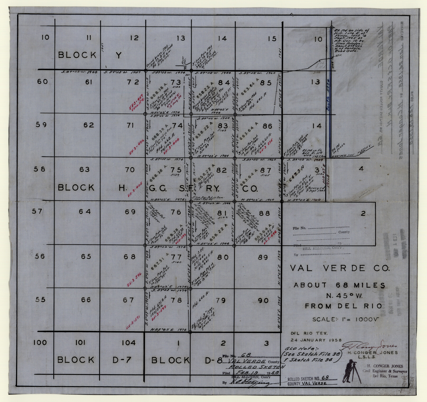
Val Verde County Rolled Sketch 68
Val Verde Co. [showing a portion of Block H, G. C. & S. F. Ry. Co. and surrounding area]
-
Map/Doc
8131
-
Collection
General Map Collection
-
Object Dates
1958/1/24 (Creation Date)
1958/2/19 (File Date)
-
People and Organizations
H. Conger Jones (Surveyor/Engineer)
-
Counties
Val Verde
-
Subjects
Surveying Rolled Sketch
-
Height x Width
17.6 x 18.7 inches
44.7 x 47.5 cm
-
Medium
linen, manuscript
-
Scale
1" = 1000 varas
-
Comments
See Val Verde County Sketch File 34 (39251) and Val Verde County Sketch File 38 (12579) for sketches and report.
Related maps
Val Verde County Sketch File 38

Print $44.00
- Digital $50.00
Val Verde County Sketch File 38
1938
Size 17.6 x 17.2 inches
Map/Doc 12579
Val Verde County Sketch File 34

Print $5.00
- Digital $50.00
Val Verde County Sketch File 34
Size 9.0 x 9.1 inches
Map/Doc 39251
Part of: General Map Collection
Lampasas County Sketch File 9a

Print $4.00
- Digital $50.00
Lampasas County Sketch File 9a
1872
Size 12.8 x 8.0 inches
Map/Doc 29410
A Topographical Map of the Government Tract Adjoining the City of Austin

Print $20.00
- Digital $50.00
A Topographical Map of the Government Tract Adjoining the City of Austin
1840
Size 41.8 x 37.5 inches
Map/Doc 4833
Red River County Working Sketch 6

Print $20.00
- Digital $50.00
Red River County Working Sketch 6
1919
Size 20.1 x 20.9 inches
Map/Doc 71989
Flight Mission No. DAG-21K, Frame 88, Matagorda County

Print $20.00
- Digital $50.00
Flight Mission No. DAG-21K, Frame 88, Matagorda County
1952
Size 18.6 x 22.4 inches
Map/Doc 86417
Throckmorton County Rolled Sketch 3

Print $20.00
- Digital $50.00
Throckmorton County Rolled Sketch 3
1987
Size 31.2 x 36.3 inches
Map/Doc 7986
Matagorda County NRC Article 33.136 Sketch 13

Print $22.00
- Digital $50.00
Matagorda County NRC Article 33.136 Sketch 13
Size 24.2 x 36.0 inches
Map/Doc 95720
Presidio County Sketch File 19a

Print $4.00
- Digital $50.00
Presidio County Sketch File 19a
1886
Size 13.8 x 8.8 inches
Map/Doc 34452
Aransas County Boundary File 7

Print $2.00
- Digital $50.00
Aransas County Boundary File 7
Size 8.8 x 14.2 inches
Map/Doc 50042
Harris County Sketch File 32a

Print $4.00
- Digital $50.00
Harris County Sketch File 32a
1895
Size 14.1 x 9.0 inches
Map/Doc 25436

McLennan County Boundary File 7

Print $8.00
- Digital $50.00
McLennan County Boundary File 7
Size 14.1 x 8.6 inches
Map/Doc 57005
Fort Bend County Working Sketch Graphic Index

Print $20.00
- Digital $50.00
Fort Bend County Working Sketch Graphic Index
1931
Size 40.7 x 41.9 inches
Map/Doc 76545
You may also like
El Paso County Boundary File 6

Print $14.00
- Digital $50.00
El Paso County Boundary File 6
Size 14.0 x 8.8 inches
Map/Doc 53080
Live Oak County Working Sketch 30

Print $20.00
- Digital $50.00
Live Oak County Working Sketch 30
1988
Size 19.0 x 25.9 inches
Map/Doc 70615
Map of Europe to illustrate Olney's school geography (Inset: Central Europe)

Print $20.00
- Digital $50.00
Map of Europe to illustrate Olney's school geography (Inset: Central Europe)
1844
Size 12.1 x 19.0 inches
Map/Doc 93546
Travis County Sketch File 47

Print $6.00
- Digital $50.00
Travis County Sketch File 47
1939
Size 14.3 x 8.9 inches
Map/Doc 38374
Map of Leagues 245, 246, 247, 250, 251, 252, 253, 254, and 321, Surveys 128, 130, 131, 132, R. E. Montgomery, and Surveys 133 and 134, Block A, Public Free School Land

Print $20.00
- Digital $50.00
Map of Leagues 245, 246, 247, 250, 251, 252, 253, 254, and 321, Surveys 128, 130, 131, 132, R. E. Montgomery, and Surveys 133 and 134, Block A, Public Free School Land
1930
Size 21.8 x 29.4 inches
Map/Doc 91270
[Sections 27 and 28, Block B-19]
![91857, [Sections 27 and 28, Block B-19], Twichell Survey Records](https://historictexasmaps.com/wmedia_w700/maps/91857-1.tif.jpg)
Print $2.00
- Digital $50.00
[Sections 27 and 28, Block B-19]
Size 14.6 x 9.1 inches
Map/Doc 91857
Hood County Sketch File 10

Print $20.00
- Digital $50.00
Hood County Sketch File 10
Size 20.6 x 22.9 inches
Map/Doc 11778
Wharton County Working Sketch 13

Print $20.00
- Digital $50.00
Wharton County Working Sketch 13
1968
Size 38.5 x 36.3 inches
Map/Doc 72477
Bowie County Working Sketch 19

Print $20.00
- Digital $50.00
Bowie County Working Sketch 19
1962
Size 23.3 x 17.9 inches
Map/Doc 67423
Baylor County Boundary File 12

Print $2.00
- Digital $50.00
Baylor County Boundary File 12
Size 11.1 x 8.6 inches
Map/Doc 50423
Zapata County Working Sketch 11

Print $20.00
- Digital $50.00
Zapata County Working Sketch 11
1958
Size 38.1 x 28.7 inches
Map/Doc 62062
Flight Mission No. DQO-2K, Frame 135, Galveston County

Print $20.00
- Digital $50.00
Flight Mission No. DQO-2K, Frame 135, Galveston County
1952
Size 18.7 x 22.5 inches
Map/Doc 85032