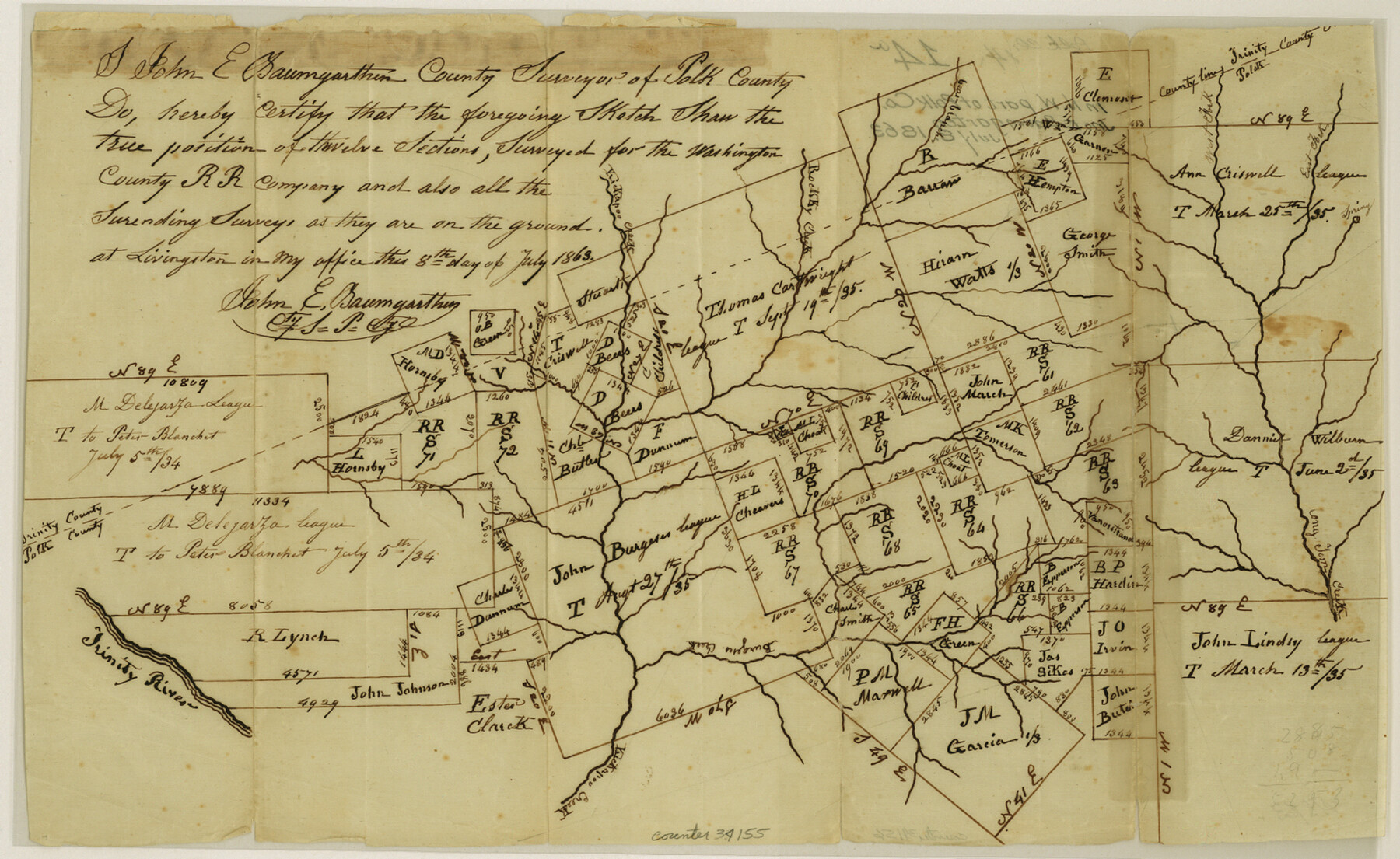
Polk County Sketch File 14a
[Sketch in northwest part of county]
-
Map/Doc
34155
-
Collection
General Map Collection
-
Object Dates
7/8/1863 (Creation Date)
-
People and Organizations
John E. Baumgarten (Surveyor/Engineer)
-
Counties
Polk Trinity
-
Subjects
Surveying Sketch File
-
Height x Width
9.0 x 14.6 inches
22.9 x 37.1 cm
-
Medium
paper, manuscript
-
Features
Kickapoo Creek
Rockky [sic] Creek
Bear Blanch Creek
Long Tom Creek
West Fork of Long Tom Creek
East Fork of Long Tom Creek
Tomerson Creek
Trinity River
Burger's Creek
Part of: General Map Collection
Lee County Working Sketch 22

Print $20.00
- Digital $50.00
Lee County Working Sketch 22
2010
Size 29.2 x 29.6 inches
Map/Doc 89271
Jeff Davis County Sketch File 12

Print $38.00
- Digital $50.00
Jeff Davis County Sketch File 12
1920
Size 14.6 x 9.1 inches
Map/Doc 27922
San Saba County

Print $20.00
- Digital $50.00
San Saba County
1877
Size 20.2 x 22.0 inches
Map/Doc 4020
Kerr County Sketch File 4

Print $10.00
- Digital $50.00
Kerr County Sketch File 4
1873
Size 8.1 x 7.7 inches
Map/Doc 28860
Wise County Sketch File A

Print $8.00
- Digital $50.00
Wise County Sketch File A
1884
Size 9.1 x 8.1 inches
Map/Doc 40609
Real County Rolled Sketch JCA

Print $20.00
- Digital $50.00
Real County Rolled Sketch JCA
Size 27.9 x 36.5 inches
Map/Doc 7470
[Surveys in Bexar County]
![93, [Surveys in Bexar County], General Map Collection](https://historictexasmaps.com/wmedia_w700/maps/93.tif.jpg)
Print $2.00
- Digital $50.00
[Surveys in Bexar County]
Size 11.3 x 6.9 inches
Map/Doc 93
Gray County Boundary File 3

Print $40.00
- Digital $50.00
Gray County Boundary File 3
Size 14.2 x 8.8 inches
Map/Doc 53854
Map of Maverick County

Print $20.00
- Digital $50.00
Map of Maverick County
1875
Size 36.3 x 23.7 inches
Map/Doc 3849
McMullen County

Print $20.00
- Digital $50.00
McMullen County
1967
Size 40.7 x 27.8 inches
Map/Doc 77363
Flight Mission No. BRA-8M, Frame 81, Jefferson County

Print $20.00
- Digital $50.00
Flight Mission No. BRA-8M, Frame 81, Jefferson County
1953
Size 16.0 x 15.8 inches
Map/Doc 85601
Motley County Sketch File 34 (S)

Print $20.00
- Digital $50.00
Motley County Sketch File 34 (S)
1951
Size 26.5 x 13.6 inches
Map/Doc 42149
You may also like
Map of Garza County, Texas

Print $20.00
- Digital $50.00
Map of Garza County, Texas
1936
Size 28.7 x 36.3 inches
Map/Doc 92648
Flight Mission No. BRE-2P, Frame 100, Nueces County

Print $20.00
- Digital $50.00
Flight Mission No. BRE-2P, Frame 100, Nueces County
1956
Size 18.5 x 22.3 inches
Map/Doc 86785
Panola County Working Sketch 33

Print $40.00
- Digital $50.00
Panola County Working Sketch 33
1983
Map/Doc 71442
Pecos County Working Sketch 44

Print $20.00
- Digital $50.00
Pecos County Working Sketch 44
1945
Size 29.6 x 35.0 inches
Map/Doc 71516
Flight Mission No. DQN-7K, Frame 9, Calhoun County

Print $20.00
- Digital $50.00
Flight Mission No. DQN-7K, Frame 9, Calhoun County
1953
Size 18.4 x 22.1 inches
Map/Doc 84460
Fisher County Sketch File 24

Print $37.00
- Digital $50.00
Fisher County Sketch File 24
1875
Size 14.3 x 8.9 inches
Map/Doc 22666
Pecos County Sketch File 118

Print $28.00
- Digital $50.00
Pecos County Sketch File 118
1933
Size 5.0 x 7.5 inches
Map/Doc 34097
Crockett County Rolled Sketch CRV

Print $40.00
- Digital $50.00
Crockett County Rolled Sketch CRV
1925
Size 35.8 x 52.3 inches
Map/Doc 8693
Aransas County Working Sketch 22

Print $20.00
- Digital $50.00
Aransas County Working Sketch 22
Size 24.3 x 18.2 inches
Map/Doc 67189
Map of Texas and Pacific Ry. Company's Surveys in the 80 Mile Reserve

Print $40.00
- Digital $50.00
Map of Texas and Pacific Ry. Company's Surveys in the 80 Mile Reserve
1885
Size 44.0 x 51.6 inches
Map/Doc 83557
Houston County Working Sketch 27

Print $20.00
- Digital $50.00
Houston County Working Sketch 27
1988
Size 34.9 x 28.5 inches
Map/Doc 66257
[Sketch of parts of Blocks M6, 2Z and B5]
![91934, [Sketch of parts of Blocks M6, 2Z and B5], Twichell Survey Records](https://historictexasmaps.com/wmedia_w700/maps/91934-1.tif.jpg)
Print $20.00
- Digital $50.00
[Sketch of parts of Blocks M6, 2Z and B5]
1917
Size 43.1 x 20.9 inches
Map/Doc 91934