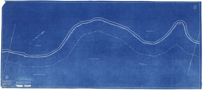
Trinity County Rolled Sketch 2

Print $20.00
- Digital $50.00
Trinity County Rolled Sketch 2
1948
Size: 34.5 x 34.9 inches
10024
Trinity County Rolled Sketch 3

Print $40.00
- Digital $50.00
Trinity County Rolled Sketch 3
1948
Size: 33.8 x 50.3 inches
10025
Trinity County Rolled Sketch 4

Print $20.00
- Digital $50.00
Trinity County Rolled Sketch 4
1948
Size: 38.5 x 42.4 inches
10026
Trinity County Sketch File 36

Print $20.00
- Digital $50.00
Trinity County Sketch File 36
Size: 43.4 x 18.1 inches
10408
Trinity County Sketch File 42

Print $60.00
- Digital $50.00
Trinity County Sketch File 42
1858
Size: 28.0 x 37.6 inches
10409
Houston County Sketch File 28

Print $20.00
- Digital $50.00
Houston County Sketch File 28
1877
Size: 21.8 x 21.3 inches
11789
Trinity County Sketch File 5

Print $64.00
- Digital $50.00
Trinity County Sketch File 5
1909
Size: 17.9 x 28.8 inches
12482
Trinity County Sketch File 18

Print $20.00
- Digital $50.00
Trinity County Sketch File 18
Size: 21.9 x 20.7 inches
12483
Trinity County Sketch File 19

Print $20.00
- Digital $50.00
Trinity County Sketch File 19
Size: 16.6 x 16.7 inches
12484
Trinity County Sketch File 20

Print $20.00
- Digital $50.00
Trinity County Sketch File 20
Size: 21.3 x 27.9 inches
12485
Trinity County Sketch File 21

Print $20.00
- Digital $50.00
Trinity County Sketch File 21
Size: 22.2 x 34.5 inches
12486
Trinity County Sketch File 25

Print $20.00
- Digital $50.00
Trinity County Sketch File 25
Size: 19.5 x 37.3 inches
12487
Trinity County Sketch File 29

Print $20.00
- Digital $50.00
Trinity County Sketch File 29
1859
Size: 18.1 x 37.1 inches
12488
Trinity County Sketch File 30A

Print $20.00
- Digital $50.00
Trinity County Sketch File 30A
1890
Size: 18.0 x 17.6 inches
12489
Trinity County Sketch File 32

Print $20.00
- Digital $50.00
Trinity County Sketch File 32
1894
Size: 22.4 x 18.3 inches
12490
Trinity County Sketch File 34

Print $20.00
- Digital $50.00
Trinity County Sketch File 34
Size: 15.9 x 20.3 inches
12491
Trinity County Sketch File 39

Print $20.00
- Digital $50.00
Trinity County Sketch File 39
1959
Size: 26.8 x 23.4 inches
12493
Trinity County Sketch File 40

Print $20.00
- Digital $50.00
Trinity County Sketch File 40
1926
Size: 16.5 x 21.8 inches
12494
Trinity County Sketch File 43

Print $40.00
- Digital $50.00
Trinity County Sketch File 43
1854
Size: 19.2 x 23.6 inches
12495
Houston County Sketch File 5a

Print $5.00
- Digital $50.00
Houston County Sketch File 5a
Size: 8.5 x 9.4 inches
26758
Houston County Sketch File 22

Print $8.00
- Digital $50.00
Houston County Sketch File 22
1852
Size: 12.6 x 8.2 inches
26789
Houston County Sketch File 23

Print $6.00
- Digital $50.00
Houston County Sketch File 23
1852
Size: 6.5 x 5.2 inches
26793
Houston County Sketch File 32

Print $4.00
- Digital $50.00
Houston County Sketch File 32
1877
Size: 10.8 x 7.1 inches
26809
[Sketch for Mineral Application 27669 - Trinity River, Frank R. Graves]
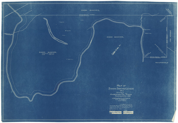
Print $20.00
- Digital $50.00
[Sketch for Mineral Application 27669 - Trinity River, Frank R. Graves]
1934
Size: 24.9 x 36.0 inches
2856
[Sketch for Mineral Application 27669 - Trinity River, Frank R. Graves]
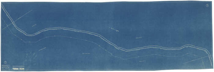
Print $40.00
- Digital $50.00
[Sketch for Mineral Application 27669 - Trinity River, Frank R. Graves]
1934
Size: 28.3 x 83.2 inches
2858
[Sketch for Mineral Application 27669 - Trinity River, Frank R. Graves]
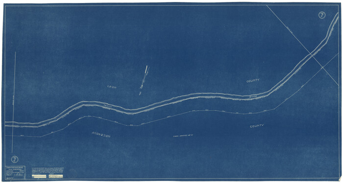
Print $40.00
- Digital $50.00
[Sketch for Mineral Application 27669 - Trinity River, Frank R. Graves]
1934
Size: 27.9 x 51.7 inches
2859
[Sketch for Mineral Application 27669 - Trinity River, Frank R. Graves]
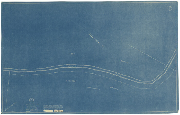
Print $20.00
- Digital $50.00
[Sketch for Mineral Application 27669 - Trinity River, Frank R. Graves]
1934
Size: 27.4 x 42.7 inches
2860
[Sketch for Mineral Application 27669 - Trinity River, Frank R. Graves]
Print $40.00
- Digital $50.00
[Sketch for Mineral Application 27669 - Trinity River, Frank R. Graves]
1934
Size: 27.4 x 61.6 inches
2861
Polk County Sketch File 14a

Print $4.00
- Digital $50.00
Polk County Sketch File 14a
1863
Size: 9.0 x 14.6 inches
34155
Trinity County Rolled Sketch 2
Print $20.00
- Digital $50.00
Trinity County Rolled Sketch 2
1948
-
Size
34.5 x 34.9 inches
-
Map/Doc
10024
-
Creation Date
1948
Trinity County Rolled Sketch 3
Print $40.00
- Digital $50.00
Trinity County Rolled Sketch 3
1948
-
Size
33.8 x 50.3 inches
-
Map/Doc
10025
-
Creation Date
1948
Trinity County Rolled Sketch 4
Print $20.00
- Digital $50.00
Trinity County Rolled Sketch 4
1948
-
Size
38.5 x 42.4 inches
-
Map/Doc
10026
-
Creation Date
1948
Trinity County Sketch File 36
Print $20.00
- Digital $50.00
Trinity County Sketch File 36
-
Size
43.4 x 18.1 inches
-
Map/Doc
10408
Trinity County Sketch File 42
Print $60.00
- Digital $50.00
Trinity County Sketch File 42
1858
-
Size
28.0 x 37.6 inches
-
Map/Doc
10409
-
Creation Date
1858
Houston County Sketch File 28
Print $20.00
- Digital $50.00
Houston County Sketch File 28
1877
-
Size
21.8 x 21.3 inches
-
Map/Doc
11789
-
Creation Date
1877
Trinity County Sketch File 5
Print $64.00
- Digital $50.00
Trinity County Sketch File 5
1909
-
Size
17.9 x 28.8 inches
-
Map/Doc
12482
-
Creation Date
1909
Trinity County Sketch File 18
Print $20.00
- Digital $50.00
Trinity County Sketch File 18
-
Size
21.9 x 20.7 inches
-
Map/Doc
12483
Trinity County Sketch File 19
Print $20.00
- Digital $50.00
Trinity County Sketch File 19
-
Size
16.6 x 16.7 inches
-
Map/Doc
12484
Trinity County Sketch File 20
Print $20.00
- Digital $50.00
Trinity County Sketch File 20
-
Size
21.3 x 27.9 inches
-
Map/Doc
12485
Trinity County Sketch File 21
Print $20.00
- Digital $50.00
Trinity County Sketch File 21
-
Size
22.2 x 34.5 inches
-
Map/Doc
12486
Trinity County Sketch File 25
Print $20.00
- Digital $50.00
Trinity County Sketch File 25
-
Size
19.5 x 37.3 inches
-
Map/Doc
12487
Trinity County Sketch File 29
Print $20.00
- Digital $50.00
Trinity County Sketch File 29
1859
-
Size
18.1 x 37.1 inches
-
Map/Doc
12488
-
Creation Date
1859
Trinity County Sketch File 30A
Print $20.00
- Digital $50.00
Trinity County Sketch File 30A
1890
-
Size
18.0 x 17.6 inches
-
Map/Doc
12489
-
Creation Date
1890
Trinity County Sketch File 32
Print $20.00
- Digital $50.00
Trinity County Sketch File 32
1894
-
Size
22.4 x 18.3 inches
-
Map/Doc
12490
-
Creation Date
1894
Trinity County Sketch File 34
Print $20.00
- Digital $50.00
Trinity County Sketch File 34
-
Size
15.9 x 20.3 inches
-
Map/Doc
12491
Trinity County Sketch File 39
Print $20.00
- Digital $50.00
Trinity County Sketch File 39
1959
-
Size
26.8 x 23.4 inches
-
Map/Doc
12493
-
Creation Date
1959
Trinity County Sketch File 40
Print $20.00
- Digital $50.00
Trinity County Sketch File 40
1926
-
Size
16.5 x 21.8 inches
-
Map/Doc
12494
-
Creation Date
1926
Trinity County Sketch File 43
Print $40.00
- Digital $50.00
Trinity County Sketch File 43
1854
-
Size
19.2 x 23.6 inches
-
Map/Doc
12495
-
Creation Date
1854
Trinity Co.

Print $20.00
- Digital $50.00
Trinity Co.
1905
-
Size
44.1 x 40.7 inches
-
Map/Doc
16906
-
Creation Date
1905
Houston County Sketch File 5a
Print $5.00
- Digital $50.00
Houston County Sketch File 5a
-
Size
8.5 x 9.4 inches
-
Map/Doc
26758
Houston County Sketch File 22
Print $8.00
- Digital $50.00
Houston County Sketch File 22
1852
-
Size
12.6 x 8.2 inches
-
Map/Doc
26789
-
Creation Date
1852
Houston County Sketch File 23
Print $6.00
- Digital $50.00
Houston County Sketch File 23
1852
-
Size
6.5 x 5.2 inches
-
Map/Doc
26793
-
Creation Date
1852
Houston County Sketch File 32
Print $4.00
- Digital $50.00
Houston County Sketch File 32
1877
-
Size
10.8 x 7.1 inches
-
Map/Doc
26809
-
Creation Date
1877
[Sketch for Mineral Application 27669 - Trinity River, Frank R. Graves]
Print $20.00
- Digital $50.00
[Sketch for Mineral Application 27669 - Trinity River, Frank R. Graves]
1934
-
Size
24.9 x 36.0 inches
-
Map/Doc
2856
-
Creation Date
1934
[Sketch for Mineral Application 27669 - Trinity River, Frank R. Graves]
Print $40.00
- Digital $50.00
[Sketch for Mineral Application 27669 - Trinity River, Frank R. Graves]
1934
-
Size
28.3 x 83.2 inches
-
Map/Doc
2858
-
Creation Date
1934
[Sketch for Mineral Application 27669 - Trinity River, Frank R. Graves]
Print $40.00
- Digital $50.00
[Sketch for Mineral Application 27669 - Trinity River, Frank R. Graves]
1934
-
Size
27.9 x 51.7 inches
-
Map/Doc
2859
-
Creation Date
1934
[Sketch for Mineral Application 27669 - Trinity River, Frank R. Graves]
Print $20.00
- Digital $50.00
[Sketch for Mineral Application 27669 - Trinity River, Frank R. Graves]
1934
-
Size
27.4 x 42.7 inches
-
Map/Doc
2860
-
Creation Date
1934
[Sketch for Mineral Application 27669 - Trinity River, Frank R. Graves]
Print $40.00
- Digital $50.00
[Sketch for Mineral Application 27669 - Trinity River, Frank R. Graves]
1934
-
Size
27.4 x 61.6 inches
-
Map/Doc
2861
-
Creation Date
1934
Polk County Sketch File 14a
Print $4.00
- Digital $50.00
Polk County Sketch File 14a
1863
-
Size
9.0 x 14.6 inches
-
Map/Doc
34155
-
Creation Date
1863