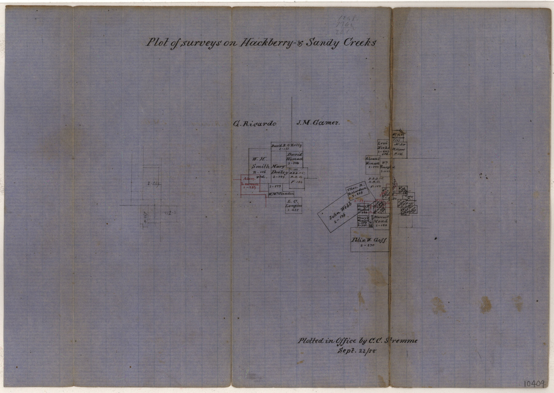
Trinity County Sketch File 42
[Multiple office sketches of surveys along multiple creeks and rivers in Trinity and Polk Counties]
-
Map/Doc
10409
-
Collection
General Map Collection
-
Object Dates
1858 (Creation Date)
12/4/1984 (File Date)
-
People and Organizations
C.C. Stremme (Draftsman)
-
Counties
Trinity Polk
-
Subjects
Surveying Sketch File
-
Height x Width
28.0 x 37.6 inches
71.1 x 95.5 cm
-
Medium
paper, manuscript
-
Features
Sumpter
Mossy Creek
Long King Creek
Brushy Creek
Caney Creek
Moskow
Sevastopol
White Rock Creek
Log Creek
Neches River
East Fork of White Rock Creek
Hackberry Creek
Hairpin Pennie Creek
Little Neches River
Kickapoo Creek
Big Piney Creek
Alabama Creek
North Fork of Alabama Creek
Elm Ceek
Piney Creek
Sandy Creek
Part of: General Map Collection
Crockett County Rolled Sketch 72

Print $20.00
- Digital $50.00
Crockett County Rolled Sketch 72
1949
Size 26.9 x 22.0 inches
Map/Doc 5613
Hale County Sketch File 15

Print $20.00
- Digital $50.00
Hale County Sketch File 15
Size 22.7 x 18.6 inches
Map/Doc 11596
Stonewall County Rolled Sketch 36B

Print $20.00
- Digital $50.00
Stonewall County Rolled Sketch 36B
Size 35.2 x 22.8 inches
Map/Doc 76404
Baylor County Sketch File 8

Print $44.00
- Digital $50.00
Baylor County Sketch File 8
1887
Size 13.0 x 8.6 inches
Map/Doc 14137
Flight Mission No. CGI-3N, Frame 142, Cameron County

Print $20.00
- Digital $50.00
Flight Mission No. CGI-3N, Frame 142, Cameron County
1954
Size 18.7 x 22.3 inches
Map/Doc 84615
Garza County Working Sketch 1

Print $20.00
- Digital $50.00
Garza County Working Sketch 1
1902
Size 39.3 x 25.6 inches
Map/Doc 63148
Winkler County Rolled Sketch 5

Print $40.00
- Digital $50.00
Winkler County Rolled Sketch 5
1927
Size 58.0 x 38.4 inches
Map/Doc 10148
Hamilton County Working Sketch 11

Print $20.00
- Digital $50.00
Hamilton County Working Sketch 11
1949
Size 45.1 x 43.7 inches
Map/Doc 63349
Dépt. des Ardennes

Print $20.00
- Digital $50.00
Dépt. des Ardennes
Size 14.5 x 20.5 inches
Map/Doc 94448
[Surveys in the Jefferson District]
![275, [Surveys in the Jefferson District], General Map Collection](https://historictexasmaps.com/wmedia_w700/maps/275.tif.jpg)
Print $2.00
- Digital $50.00
[Surveys in the Jefferson District]
1841
Size 8.3 x 8.0 inches
Map/Doc 275
Flight Mission No. BRE-1P, Frame 97, Nueces County

Print $20.00
- Digital $50.00
Flight Mission No. BRE-1P, Frame 97, Nueces County
1956
Size 18.3 x 22.0 inches
Map/Doc 86668
Harris County Working Sketch 104

Print $20.00
- Digital $50.00
Harris County Working Sketch 104
1980
Size 17.2 x 10.3 inches
Map/Doc 65996
You may also like
San Jacinto County Working Sketch 41

Print $20.00
- Digital $50.00
San Jacinto County Working Sketch 41
1979
Size 44.6 x 35.2 inches
Map/Doc 63754
Wharton County Rolled Sketch 6

Print $20.00
- Digital $50.00
Wharton County Rolled Sketch 6
1901
Size 23.7 x 30.0 inches
Map/Doc 8230
Block 34, Township 5 South

Print $3.00
- Digital $50.00
Block 34, Township 5 South
1876
Size 9.6 x 9.6 inches
Map/Doc 90752
Harris County Working Sketch 56

Print $20.00
- Digital $50.00
Harris County Working Sketch 56
1950
Size 33.2 x 31.6 inches
Map/Doc 65948
Gaines County Working Sketch 37

Print $20.00
- Digital $50.00
Gaines County Working Sketch 37
Size 21.5 x 16.6 inches
Map/Doc 69337
Portion of Culberson County, Texas

Print $20.00
- Digital $50.00
Portion of Culberson County, Texas
1948
Size 30.9 x 33.0 inches
Map/Doc 92556
Hill County Sketch File 18

Print $26.00
- Digital $50.00
Hill County Sketch File 18
1852
Size 8.6 x 4.9 inches
Map/Doc 26486
Kendall County Rolled Sketch 8

Print $20.00
- Digital $50.00
Kendall County Rolled Sketch 8
1994
Size 17.0 x 18.3 inches
Map/Doc 6461
Coke County Rolled Sketch 19

Print $20.00
- Digital $50.00
Coke County Rolled Sketch 19
1954
Size 18.5 x 25.8 inches
Map/Doc 5519
Intracoastal Waterway in Texas - Corpus Christi to Point Isabel including Arroyo Colorado to Mo. Pac. R.R. Bridge Near Harlingen

Print $20.00
- Digital $50.00
Intracoastal Waterway in Texas - Corpus Christi to Point Isabel including Arroyo Colorado to Mo. Pac. R.R. Bridge Near Harlingen
1933
Size 28.2 x 40.7 inches
Map/Doc 61855
Kent County Sketch File 3

Print $4.00
- Digital $50.00
Kent County Sketch File 3
Size 14.2 x 8.7 inches
Map/Doc 28825
Brown County Sketch File 16

Print $6.00
- Digital $50.00
Brown County Sketch File 16
1872
Size 10.8 x 10.1 inches
Map/Doc 16612