Baylor County Sketch File 8
[Field notes and sketch of area south of Brazos River and north of County School Land Leagues in south part of county]
-
Map/Doc
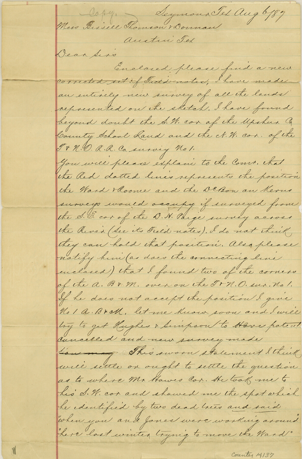
14137
-
Collection
General Map Collection
-
Object Dates
1887/8/5 (Creation Date)
1887/8/10 (File Date)
-
People and Organizations
A.D. Kerr (Surveyor/Engineer)
-
Counties
Baylor
-
Subjects
Surveying Sketch File
-
Height x Width
13.0 x 8.6 inches
33.0 x 21.8 cm
-
Medium
multi-page, multi-format
-
Features
Salt Fork of the Brazos River
Miller Island
Wagon Creek
Rocky Canyon Creek
Twin Mountains
Part of: General Map Collection
Flight Mission No. BRA-9M, Frame 80, Jefferson County

Print $20.00
- Digital $50.00
Flight Mission No. BRA-9M, Frame 80, Jefferson County
1953
Size 18.6 x 22.5 inches
Map/Doc 85663
Rockwall County Boundary File 2

Print $12.00
- Digital $50.00
Rockwall County Boundary File 2
Size 14.4 x 8.9 inches
Map/Doc 58385
Located Line of the Panhandle & Gulf Ry. through State Lands, Public School and University, Right of Way 200 feet wide, in Brewster County, Texas.

Print $40.00
- Digital $50.00
Located Line of the Panhandle & Gulf Ry. through State Lands, Public School and University, Right of Way 200 feet wide, in Brewster County, Texas.
1904
Size 14.8 x 99.1 inches
Map/Doc 64059
Flight Mission No. DQN-2K, Frame 40, Calhoun County

Print $20.00
- Digital $50.00
Flight Mission No. DQN-2K, Frame 40, Calhoun County
1953
Size 18.6 x 22.2 inches
Map/Doc 84245
Ward County Working Sketch 51

Print $40.00
- Digital $50.00
Ward County Working Sketch 51
1980
Size 34.4 x 52.1 inches
Map/Doc 72357
Pecos County Rolled Sketch 180

Print $20.00
- Digital $50.00
Pecos County Rolled Sketch 180
Size 33.6 x 42.0 inches
Map/Doc 9752
La Salle County Sketch File 14

Print $4.00
- Digital $50.00
La Salle County Sketch File 14
Size 6.4 x 6.7 inches
Map/Doc 29483
Dimmit County Sketch File 17

Print $15.00
- Digital $50.00
Dimmit County Sketch File 17
1886
Size 11.0 x 13.7 inches
Map/Doc 21081
Bandera County Working Sketch 60

Print $20.00
- Digital $50.00
Bandera County Working Sketch 60
2004
Size 32.1 x 43.6 inches
Map/Doc 83562
Section IX, Galveston Harbor and Bar

Print $20.00
- Digital $50.00
Section IX, Galveston Harbor and Bar
1850
Size 30.0 x 45.7 inches
Map/Doc 69855
Upton County Rolled Sketch 35

Print $20.00
- Digital $50.00
Upton County Rolled Sketch 35
1951
Size 37.3 x 19.2 inches
Map/Doc 8077
Presidio County

Print $40.00
- Digital $50.00
Presidio County
1875
Size 98.1 x 58.7 inches
Map/Doc 16792
You may also like
Williamson County Sketch File 11

Print $4.00
- Digital $50.00
Williamson County Sketch File 11
Size 8.2 x 9.2 inches
Map/Doc 40324
Harris County Sketch File 31

Print $6.00
- Digital $50.00
Harris County Sketch File 31
Size 14.0 x 8.9 inches
Map/Doc 25426
Armstrong County Sketch File A-10

Print $40.00
- Digital $50.00
Armstrong County Sketch File A-10
Size 22.6 x 35.6 inches
Map/Doc 10852
Crane County Sketch File 7

Print $6.00
- Digital $50.00
Crane County Sketch File 7
1886
Size 10.3 x 11.0 inches
Map/Doc 19567
Presidio County Rolled Sketch 81

Print $20.00
- Digital $50.00
Presidio County Rolled Sketch 81
Size 19.2 x 36.8 inches
Map/Doc 7368
Hood County Rolled Sketch 5

Print $20.00
- Digital $50.00
Hood County Rolled Sketch 5
1980
Size 29.9 x 32.2 inches
Map/Doc 6221
Rusk County Rolled Sketch 4

Print $20.00
- Digital $50.00
Rusk County Rolled Sketch 4
1895
Size 47.8 x 33.9 inches
Map/Doc 9874
Gillespie County Boundary File 6

Print $2.00
- Digital $50.00
Gillespie County Boundary File 6
Size 11.3 x 8.9 inches
Map/Doc 53770
Lampasas County Boundary File 16a

Print $28.00
- Digital $50.00
Lampasas County Boundary File 16a
Size 13.9 x 8.4 inches
Map/Doc 56223
Map of Lands in Pecos County, Texas, Block 1, I. and G. N. RR. Company

Print $20.00
- Digital $50.00
Map of Lands in Pecos County, Texas, Block 1, I. and G. N. RR. Company
1934
Size 21.9 x 16.8 inches
Map/Doc 91640
Howard County Working Sketch 2

Print $20.00
- Digital $50.00
Howard County Working Sketch 2
1903
Size 21.7 x 20.9 inches
Map/Doc 66268
Flight Mission No. DQO-8K, Frame 56, Galveston County

Print $20.00
- Digital $50.00
Flight Mission No. DQO-8K, Frame 56, Galveston County
1952
Size 18.7 x 17.6 inches
Map/Doc 85163