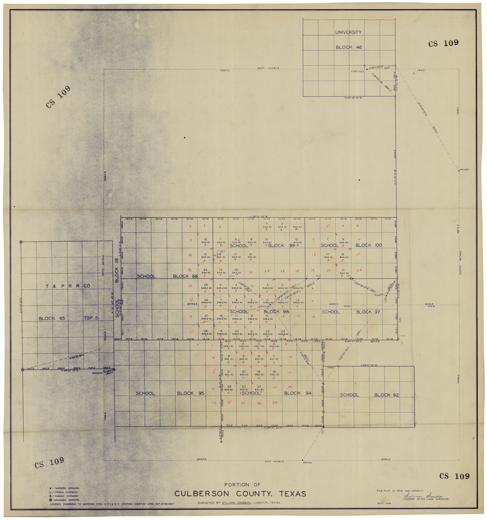
Portion of Culberson County, Texas
CS109
-
Map/Doc
92556
-
Collection
Twichell Survey Records
-
Object Dates
9/1948 (Creation Date)
-
People and Organizations
Sylvan Sanders (Surveyor/Engineer)
-
Counties
Culberson
-
Height x Width
30.9 x 33.0 inches
78.5 x 83.8 cm
Part of: Twichell Survey Records
Sketch from Ward and Crane Counties

Print $20.00
- Digital $50.00
Sketch from Ward and Crane Counties
Size 42.9 x 23.6 inches
Map/Doc 92557
[Area around J. E. Arnold survey]
![91885, [Area around J. E. Arnold survey], Twichell Survey Records](https://historictexasmaps.com/wmedia_w700/maps/91885-1.tif.jpg)
Print $2.00
- Digital $50.00
[Area around J. E. Arnold survey]
Size 15.3 x 8.2 inches
Map/Doc 91885
[H. & T. C. RR. Company, Block 47]
![91243, [H. & T. C. RR. Company, Block 47], Twichell Survey Records](https://historictexasmaps.com/wmedia_w700/maps/91243-1.tif.jpg)
Print $20.00
- Digital $50.00
[H. & T. C. RR. Company, Block 47]
Size 27.8 x 26.4 inches
Map/Doc 91243
Rio Vista Annex, An Addition to the City of Lubbock

Print $20.00
- Digital $50.00
Rio Vista Annex, An Addition to the City of Lubbock
1947
Size 19.4 x 12.6 inches
Map/Doc 92754

[H. & G. N. Block 1]
![90939, [H. & G. N. Block 1], Twichell Survey Records](https://historictexasmaps.com/wmedia_w700/maps/90939-1.tif.jpg)
Print $20.00
- Digital $50.00
[H. & G. N. Block 1]
1902
Size 13.5 x 16.4 inches
Map/Doc 90939
Working Sketch in Bailey County

Print $20.00
- Digital $50.00
Working Sketch in Bailey County
1906
Size 22.2 x 12.5 inches
Map/Doc 90184
[Area around Gillespie County, Bastrop County and El Paso County School Land Leagues]
![90866, [Area around Gillespie County, Bastrop County and El Paso County School Land Leagues], Twichell Survey Records](https://historictexasmaps.com/wmedia_w700/maps/90866-2.tif.jpg)
Print $20.00
- Digital $50.00
[Area around Gillespie County, Bastrop County and El Paso County School Land Leagues]
1886
Size 25.7 x 29.8 inches
Map/Doc 90866
[Sketch of Randall County]
![91756, [Sketch of Randall County], Twichell Survey Records](https://historictexasmaps.com/wmedia_w700/maps/91756-1.tif.jpg)
Print $20.00
- Digital $50.00
[Sketch of Randall County]
Size 21.3 x 18.2 inches
Map/Doc 91756
Sketch showing north boundary line of XIT lands and conflict of enclosure with L. & H. Blum land

Print $2.00
- Digital $50.00
Sketch showing north boundary line of XIT lands and conflict of enclosure with L. & H. Blum land
1906
Size 14.4 x 7.8 inches
Map/Doc 90519
[I. & G. N. Block 1]
![91588, [I. & G. N. Block 1], Twichell Survey Records](https://historictexasmaps.com/wmedia_w700/maps/91588-1.tif.jpg)
Print $20.00
- Digital $50.00
[I. & G. N. Block 1]
Size 11.8 x 18.6 inches
Map/Doc 91588
The T. B. Duggan Subdivision of League 125 and N 3/5 of League 126, Coke County School Lands, Cochran County, Texas

Print $20.00
- Digital $50.00
The T. B. Duggan Subdivision of League 125 and N 3/5 of League 126, Coke County School Lands, Cochran County, Texas
1920
Size 14.9 x 21.5 inches
Map/Doc 90300
You may also like
Red River County Working Sketch 49

Print $20.00
- Digital $50.00
Red River County Working Sketch 49
1970
Size 31.3 x 21.5 inches
Map/Doc 72032
Flight Mission No. CRK-8P, Frame 121, Refugio County

Print $20.00
- Digital $50.00
Flight Mission No. CRK-8P, Frame 121, Refugio County
1956
Size 18.3 x 22.2 inches
Map/Doc 86976
Little River, Faubion Bridge Sheet

Print $20.00
- Digital $50.00
Little River, Faubion Bridge Sheet
1914
Size 18.5 x 27.6 inches
Map/Doc 69682
Donley County Sketch File B10

Print $24.00
- Digital $50.00
Donley County Sketch File B10
1938
Size 14.3 x 9.1 inches
Map/Doc 21272
[Blocks D, Q, and Z]
![92522, [Blocks D, Q, and Z], Twichell Survey Records](https://historictexasmaps.com/wmedia_w700/maps/92522-1.tif.jpg)
Print $20.00
- Digital $50.00
[Blocks D, Q, and Z]
Size 17.9 x 22.6 inches
Map/Doc 92522
Map of Sutton County

Print $20.00
- Digital $50.00
Map of Sutton County
1887
Size 24.5 x 29.5 inches
Map/Doc 4061
Enochs Land situated in Bailey and Cochran Counties, Texas

Print $20.00
- Digital $50.00
Enochs Land situated in Bailey and Cochran Counties, Texas
Size 28.9 x 35.6 inches
Map/Doc 90194
Carta geográfica que comprende en su extensión mucha parte del arzobispado de México, y alguna de los obispados de Puebla, Valladolid de Michoacán, Guadalajara y Durango, confinantes entre si

Carta geográfica que comprende en su extensión mucha parte del arzobispado de México, y alguna de los obispados de Puebla, Valladolid de Michoacán, Guadalajara y Durango, confinantes entre si
1779
Size 33.9 x 22.0 inches
Map/Doc 97079
Culberson County Working Sketch Graphic Index, Sheet B (Sketches 41 to Most Recent)

Print $40.00
- Digital $50.00
Culberson County Working Sketch Graphic Index, Sheet B (Sketches 41 to Most Recent)
1943
Size 52.5 x 32.5 inches
Map/Doc 76515
Frio County Rolled Sketch 23

Print $20.00
- Digital $50.00
Frio County Rolled Sketch 23
1962
Size 39.4 x 40.8 inches
Map/Doc 8912
Baylor County Sketch File 8

Print $44.00
- Digital $50.00
Baylor County Sketch File 8
1887
Size 13.0 x 8.6 inches
Map/Doc 14137
Kimble County Working Sketch 72

Print $20.00
- Digital $50.00
Kimble County Working Sketch 72
1966
Size 28.7 x 17.6 inches
Map/Doc 70140