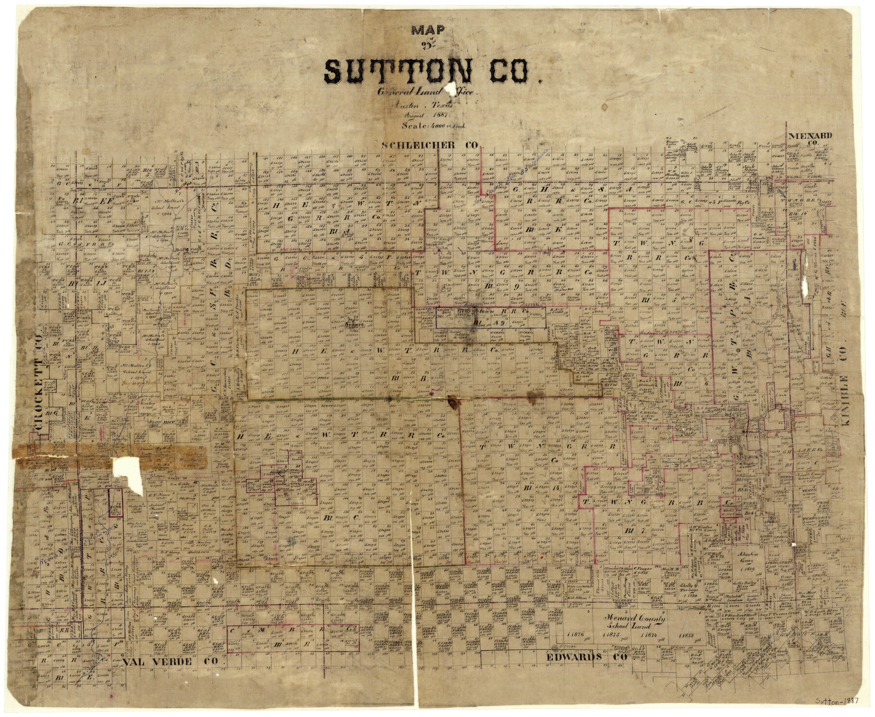
Map of Sutton County
-
Map/Doc
4061
-
Collection
General Map Collection
-
Object Dates
8/1887 (Creation Date)
-
People and Organizations
Texas General Land Office (Publisher)
-
Counties
Sutton
-
Subjects
County
-
Height x Width
24.5 x 29.5 inches
62.2 x 74.9 cm
-
Features
[Road] to Fort McKavett
Pecan Creek
[Road] to Fort Clark
Pecan Spring
Sonora
North Fork of Llano River
Devil's River
Green Lake
Fort Terret
Part of: General Map Collection
Hunt County Boundary File 7a

Print $40.00
- Digital $50.00
Hunt County Boundary File 7a
Size 27.9 x 8.5 inches
Map/Doc 55235
Smith County Boundary File 1

Print $52.00
- Digital $50.00
Smith County Boundary File 1
1922
Size 14.3 x 8.8 inches
Map/Doc 58791
Duval County Boundary File 3a

Print $8.00
- Digital $50.00
Duval County Boundary File 3a
Size 12.7 x 8.0 inches
Map/Doc 52726
San Jacinto County Working Sketch 8
Print $20.00
- Digital $50.00
San Jacinto County Working Sketch 8
1935
Size 38.4 x 42.9 inches
Map/Doc 63721
Webb County Sketch File 5-1

Print $4.00
- Digital $50.00
Webb County Sketch File 5-1
Size 3.7 x 12.6 inches
Map/Doc 39733
Pecos County Rolled Sketch 166

Print $22.00
- Digital $50.00
Pecos County Rolled Sketch 166
Size 32.5 x 37.6 inches
Map/Doc 9747
La Salle County Working Sketch 38

Print $20.00
- Digital $50.00
La Salle County Working Sketch 38
1961
Size 26.6 x 18.4 inches
Map/Doc 70339
Nueces County Rolled Sketch 13

Print $20.00
- Digital $50.00
Nueces County Rolled Sketch 13
1930
Size 26.5 x 18.5 inches
Map/Doc 6869
Flight Mission No. DQO-8K, Frame 76, Galveston County

Print $20.00
- Digital $50.00
Flight Mission No. DQO-8K, Frame 76, Galveston County
1952
Size 18.6 x 22.5 inches
Map/Doc 85180
Flight Mission No. DCL-4C, Frame 5, Kenedy County

Print $20.00
- Digital $50.00
Flight Mission No. DCL-4C, Frame 5, Kenedy County
1943
Size 18.6 x 22.3 inches
Map/Doc 85806
Presidio County Rolled Sketch 6

Print $20.00
- Digital $50.00
Presidio County Rolled Sketch 6
Size 33.0 x 20.6 inches
Map/Doc 7330
Bosque County Sketch File 7

Print $4.00
- Digital $50.00
Bosque County Sketch File 7
1852
Size 12.7 x 7.7 inches
Map/Doc 14750
You may also like
Lubbock County Texas

Print $20.00
- Digital $50.00
Lubbock County Texas
Size 42.7 x 46.7 inches
Map/Doc 89892
[Sketch showing PSL Block AX and C. C. S. D. & R. G. N. G. RR. Co. Block G]
![90912, [Sketch showing PSL Block AX and C. C. S. D. & R. G. N. G. RR. Co. Block G], Twichell Survey Records](https://historictexasmaps.com/wmedia_w700/maps/90912-1.tif.jpg)
Print $20.00
- Digital $50.00
[Sketch showing PSL Block AX and C. C. S. D. & R. G. N. G. RR. Co. Block G]
Size 26.2 x 16.4 inches
Map/Doc 90912
[Sketch showing Blocks 1, 3, 5, K14, 2Z, 7]
![91824, [Sketch showing Blocks 1, 3, 5, K14, 2Z, 7], Twichell Survey Records](https://historictexasmaps.com/wmedia_w700/maps/91824-1.tif.jpg)
Print $20.00
- Digital $50.00
[Sketch showing Blocks 1, 3, 5, K14, 2Z, 7]
Size 23.6 x 20.0 inches
Map/Doc 91824
Parker County Rolled Sketch 6

Print $20.00
- Digital $50.00
Parker County Rolled Sketch 6
Size 28.3 x 34.1 inches
Map/Doc 7207
The Republic County of Brazoria. Proposed, Late Fall 1837

Print $20.00
The Republic County of Brazoria. Proposed, Late Fall 1837
2020
Size 13.0 x 21.7 inches
Map/Doc 96109
Laguna Madre, Register No. 1476A

Print $40.00
- Digital $50.00
Laguna Madre, Register No. 1476A
1880
Size 31.3 x 53.3 inches
Map/Doc 73604
Kinney County Working Sketch 1

Print $20.00
- Digital $50.00
Kinney County Working Sketch 1
Size 22.6 x 24.0 inches
Map/Doc 70183
Val Verde County Working Sketch 31

Print $20.00
- Digital $50.00
Val Verde County Working Sketch 31
1938
Size 19.2 x 15.3 inches
Map/Doc 72166
Loving County Boundary File 2

Print $40.00
- Digital $50.00
Loving County Boundary File 2
Map/Doc 90033
Coast of Texas from head of East Bay Galveston Harbor to Sabine Pass

Print $40.00
- Digital $50.00
Coast of Texas from head of East Bay Galveston Harbor to Sabine Pass
1882
Size 32.2 x 54.1 inches
Map/Doc 69839
[Sketch between Wheeler County and Oklahoma]
![89674, [Sketch between Wheeler County and Oklahoma], Twichell Survey Records](https://historictexasmaps.com/wmedia_w700/maps/89674-1.tif.jpg)
Print $40.00
- Digital $50.00
[Sketch between Wheeler County and Oklahoma]
Size 64.9 x 10.2 inches
Map/Doc 89674
Nolan County Working Sketch 3

Print $20.00
- Digital $50.00
Nolan County Working Sketch 3
1947
Size 23.5 x 17.2 inches
Map/Doc 71294